


Signal No. 1 hoisted over 22 areas as 'Aghon' nears tropical storm category
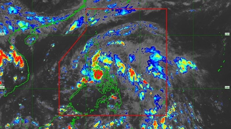
MANILA, Philippines — Tropical Depression Aghon maintained its strength as it continues to move northwestward over Sibuyan Sea, according to state weather bureau PAGASA.
The cyclone was last observed by the state weather bureau over the coastal waters of Sibuyan Island on Saturday afternoon.
- Strength: 45 kilometers/hour near the center
- Gustiness: up to 70 km/h
- Direction: west northwestward
- Movement: 20 km/h
"Aghon is forecast to move generally west northwestward to northwestward over Sibuyan Sea and Tayabas Bay, and may possibly make landfall over Marinduque within the next 12 hours. During this period, weakening into Low Pressure Area (LPA) is not ruled out," said PAGASA.
"Aghon will then continue to move northward and may possibly make another landfall over Batangas or Quezon and traverse CALABARZON area. Re-intensification is possible and it may reach tropical storm category by tomorrow."
Tropical Cyclone Wind Signals (TCWS) have likewise been hoisted by PAGASA over certain areas in Luzon due to a general wind threat, which may be slightly stronger in coastal and upland regions.
Signal No. 1
- eastern portion of Quirino (Maddela, Nagtipunan)
- eastern portion of Nueva Vizcaya (Alfonso Castaneda)
- Bulacan
- eastern portion of Nueva Ecija (General Tinio, Gabaldon, Bongabon, Pantabangan, Rizal, General Mamerto Natividad, Laur, Palayan City, Peñaranda, San Leonardo, City of Gapan, Cabanatuan City, Santa Rosa, San Isidro, Cabiao, San Antonio, Jaen)
- eastern portion of Pampanga (Candaba, San Luis, San Simon, Apalit, Santa Ana, Arayat)
- Aurora
- Quezon including Pollilo Islands
- Metro Manila
- eastern portion of Cavite (Mendez, Gen. Mariano Alvarez, Noveleta, Silang, City of Dasmariñas, City of General Trias, Amadeo, Carmona, Kawit, Rosario, Tanza, Alfonso, Tagaytay City, Bacoor City, Trece Martires City, Imus City, Indang)
- Laguna
- Rizal
- eastern portion of Batangas (Lobo, Taysan, Rosario, Padre Garcia, San Juan, Santo Tomas, Batangas City, Tingloy, Bauan, San Luis, Mabini, San Pascual, San Jose, Ibaan, Lipa City, Mataasnakahoy, Balete, Malvar, Calaca, Cuenca, Talisay, Agoncillo, Lemery, City of Tanauan, Alitagtag, San Nicolas, Laurel, Santa Teresita, Taal)
- Marinduque
- northeastern portion of Oriental Mindoro (Pinamalayan, Pola, Naujan, Victoria, Socorro, City of Calapan, Bansud, Gloria, Baco, San Teodoro, Puerto Galera, Bongabong, Roxas)
- eastern portion of Occidental Mindoro (Sablayan, Abra de Ilog)
- Romblon
- Camarines Norte
- Camarines Sur
- Catanduanes
- Albay
- Sorsogon
- northern portion of Masbate (Uson, Dimasalang, City of Masbate, Mobo, Cawayan, Palanas, Aroroy, Balud, Mandaon, Milagros, Baleno) including Burias and Ticao Islands
Minimal to minor impacts from strong winds are seen within any of the areas under Signal No. 1. CALABARZON, MIMAROPA, Central Luzon and Cagayan may soon be included in said areas.
"The highest possible Wind Signal that may be hoisted during the passage of AGHON is Wind Signal No. 2," PAGASA continued.
Flooding, rain-induced landslides
The following are PAGASA's current forecast accumulated rainfall in the following areas due to Aghon from Saturday to Sunday afternoon.
- 100-200 mm: Quezon including Polillo Islands, the eastern portions of Laguna and Rizal, Marinduque, Romblon, Camarines Norte, Camarines Sur, and Catanduanes
- 50-100 mm: Eastern portion of Isabela, Aurora, Metro Manila, the rest of CALABARZON, Oriental Mindoro, Occidental Mindoro, and the northern portion of Western Visayas
Rainfall is generally hgiher in elevated or mountainous areas. Due to this, floooding and rain-induced landslides are possible especially in areas that are highly or very highly susceptible to these hazards as identified in hazard maps and in localities.
"Around tomorrow afternoon or evening, Aghon will begin to recurve towards the northeast," PAGASA said.
"As it moves over the Philippine Sea, the tropical cyclone is forecast to continuously intensify and may reach typhoon category on Wednesday. On the track forecast, Aghon may exit the PAR region no earlier than Tuesday."
Residents are also advised to monitor the latest severe weather bulletin issued by the bureau every six hours.
"Aghon" is the first tropical cyclone within the Philippine area of responsibility for 2024, this as the weakening El Niño phenomenon increased the chances of below-average rainfall.


- Latest
- Trending

