


Typhoon Egay makes landfall in Aparri, Cagayan
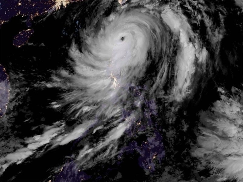
MANILA, Philippines — Typhoon Egay (international name: Doksuri) made its landfall over Fuga Island in Aparri, Cagayan before dawn on Wednesday, state weather bureau PAGASA said.
Egay, previously a super typhoon, was downgraded into a typhoon category on Tuesday evening.
As of 4 a.m. Wednesday, Egay was seen over the coastal waters of Aparri, Cagayan, with peak winds of 175 kilometers per hour near the center, gustiness of up to 240 kph, and central pressure of 935 hPa.
The typhoon is moving westward at 20 kph.
PAGASA predicted that Egay may "exhibit trochoidal or wobbling motion while in the vicinity of the Babuyan Islands."
"As such, a landfall over northwestern Cagayan is not ruled out," the state weather bureau said.
The following areas are under tropical cyclone warning signal.
Signal No. 4
- northern portion of Cagayan (Santa Ana, Gonzaga, Claveria, Sanchez-Mira, Pamplona, Abulug, Ballesteros, Aparri, Buguey, Santa Teresita, Camalaniugan, Santa Praxedes) including Babuyan Islands
- northern portion of Apayao (Calanasan, Luna, Santa Marcela)
- northern portion of Ilocos Norte (Burgos, Bangui, Dumalneg, Pagudpud, Adams, Pasuquin, Vintar, Bacarra)
Residents in these areas should be prepared for typhoon-force winds ranging from 118 to 184 kph within the next 12 hours, which could pose a significant to severe threat to life and property.
Signal No. 3
- Batanes
- rest of Cagayan
- rest of Apayao
- northern portion of Kalinga (Rizal, Pinukpuk, Balbalan)
- northern portion of Abra (Tineg, Lagayan, Lacub, Danglas, Bangued, La Paz, San Juan, Dolores, Tayum, Lagangilang, Malibcong, Licuan-Baay, Peñarrubia, Pidigan, Langiden, San Quintin, Bucay, San Isidro, Sallapadan)
- rest of Ilocos Norte
- northern portion of Ilocos Sur (Magsingal, San Juan, Cabugao, Sinait, San Vicente, Santo Domingo, San Ildefonso, Bantay, Santa Catalina, City of Vigan, Caoayan, Santa, Nagbukel, Narvacan)
Residents in these areas should prepare for storm-force winds ranging from 89 to 117 kph within the next 18 hours, which may pose a moderate to significant threat to life and property.
Signal No. 2
- Isabela
- rest of Kalinga
- Mountain Province
- Ifugao
- Benguet
- rest of Abra
- rest of Ilocos Sur
- La Union
Residents in these areas may experience gale-force winds ranging from 62 to 88 kph within the next 24 hours, posing a potential minor to moderate threat to life and property.
Signal No. 1
- Aurora
- Quirino
- Nueva Vizcaya
- Pangasinan
- Nueva Ecija
- Tarlac
- Pampanga
- Bulacan
- Zambales
- Bataan
- Metro Manila
- Rizal
- Cavite
- Laguna
- northern portion of Batangas (Talisay, City of Tanauan, Santo Tomas, Balete, Malvar, Lipa City), the northern and central portion of Quezon (Pitogo, Calauag, Infanta, Lopez, Guinayangan, Unisan, Plaridel, Quezon, Alabat, Padre Burgos, Mauban, General Nakar, Perez, Agdangan, Gumaca, Atimonan, Real, Tagkawayan, Lucena City, Pagbilao, Lucban, Sampaloc, City of Tayabas, Dolores, Sariaya, Candelaria, Tiaong, San Antonio) including Polillo Islands
- Camarines Norte
- northern portion of Camarines Sur (Siruma, Tinambac, Goa, Lagonoy, Caramoan, Cabusao, Sipocot, Garchitorena, Ragay, Del Gallego, Calabanga, Presentacion, Lupi), and the northern portion of Catanduanes (Pandan, Bagamanoc, Panganiban, Viga, Caramoran)
Residents in these areas should expect strong winds ranging from 39 to 61 kph within the next 36 hours, with minimal to minor threat to life and property.
Rainfall
PAGASA issued issued the following heavy rainfall warnings:
- Above 200 mm: northwestern portion of Cagayan including Babuyan Islands, northern portion of Apayao, Abra, Ilocos Norte and Ilocos Sur
- 00-200 mm: Batanes, northeastern and central portions of Cagayan, rest of Apayao, western portion of Kalinga, western portion of Mountain Province, Benguet and La Union
- 50-100 mm: rest of Cagayan, rest of Kalinga, rest of Mountain Province, western portion of Ifugao, western portion of Nueva Vizcaya, Pangasinan and Zambales.
Residents in elevated or mountainous areas are urged to be vigilant, as flooding and rain-induced landslides are highly likely, especially in regions identified as highly or very highly susceptible to these hazards.
PAGASA said the southwest monsoon, enhanced by Egay, will continue to bring occasional to monsoon rains over the western portions of central Luzon, southern Luzon, and Visayas in the next three days.
Egay is expected to exit the Philippine Area of Responsibility on Thursday morning.


- Latest
- Trending


