Signal No. 3 up in parts of Cagayan, Isabela as Florita nears Northern Luzon
MANILA, Philippines (Updated 9:56 a.m.) — PAGASA on Tuesday morning placed parts of Cagayan and Isabela provinces under Tropical Wind Cyclone Signal No. 3 as Severe Tropical Storm Florita (Ma-on) moves closer to land.
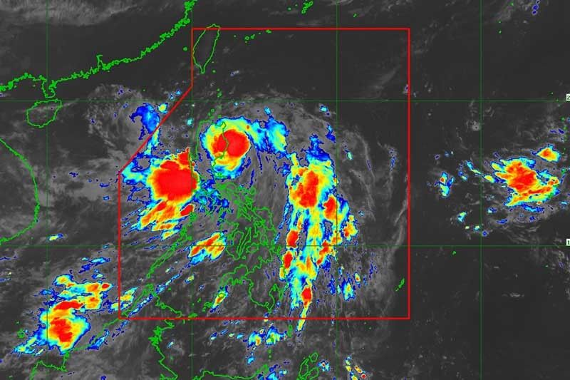
Florita, which intensified to a severe tropical storm early Tuesday, was last seen over the coastal waters of Palanan, Isabela. The cyclone has peak winds of 95 kph near the center and gusts of up to 115 kph.
Heading north northwest at 20 kph, Florita is forecast to make a landfall in the vicinity of northern Isabela (coast of Palanan, Maconacon or Divilacan) this morning or in the vicinity of Cagayan (coast of Gattaran, Baggao, or Peñablanca) before noon or by early afternoon.
PAGASA raised winds signals over the following areas in Luzon:
Signal No. 3 (Storm-force winds prevailing or expected within 18 hours)
- Southern portion of Babuyan Islands (Camiguin Is., Fuga Is., Dalupiri Is.
- Northern and eastern portion of mainland Cagayan (Santa Praxedes, Claveria, Sanchez-Mira, Pamplona, Abulug, Ballesteros, Aparri, Buguey, Camalaniugan, Santa Teresita, Santa Ana, Gonzaga, Lal-Lo, Gattaran, Baggao, Peñablanca)
- Eastern portion of Isabela (Maconacon, Divilacan, Palanan)
According to PAGASA, winds may cause “moderate to significant threat to life and property.”
Signal No. 2 (Gale-force winds prevailing or expected within 24 hours)
- Rest of mainland Cagayan
- Rest of Babuyan Islands
- Rest of Isabela
- Quirino
- Northern and eastern portion of Nueva Vizcaya (Quezon, Diadi, Bagabag, Villaverde, Solano, Kasibu)
- Apayao
- Abra
- Kalinga
- Mountain Province
- Ifugao
- Northern portion of Benguet (Buguias, Bakun, Mankayan, Kibungan)
- Ilocos Norte
- Ilocos Sur
- Northern portion of Aurora (Dilasag, Casiguran, Dinalungan, Dipaculao)
Winds may cause “minor to moderate threat to life and property.”
Signal No. 1 (Strong winds prevailing or expected within 36 hours)
- Batanes
- Rest of Nueva Vizcaya
- Rest of Benguet
- La Union
- Pangasinan
- Eastern portion of Tarlac (San Clemente, Camiling, Moncada, San Manuel, Anao, Santa Ignacia, Gerona, Paniqui, Ramos, Pura, Victoria, La Paz, City of Tarlac, Concepcion)
- Nueva Ecija
- Rest of Aurora
- Eastern portion of Pampanga (Magalang, Arayat, Candaba)
- Eastern portion of Bulacan (San Ildefonso, San Miguel, Doña Remedios Trinidad, San Rafael, Angat, Norzagaray, City of San Jose del Monte)
- Eastern portion of Rizal (Rodriguez, San Mateo, City of Antipolo, Tanay, Baras)
- Northern portion of Quezon (General Nakar, Infanta, Real, Mauban, Perez, Alabat, Quezon, Calauag) including Polillo Islands
- Northern portion of Laguna (Santa Maria, Famy, Siniloan, Pangil, Pakil, Paete)
- Camarines Norte
Winds may cause “minimal to minor life threat,” PAGASA said.
What to expect
According to PAGASA, heavy to intense with at times torrential rains will be experienced in Cagayan, Isabela, Cordillera Administrative Region, Ilocos region, and Zambales this Tuesday.
Residents of the northern portion of Aurora, Bataan, Tarlac, Pampanga, Bulacan, Metro Manila, Cavite, Rizal, and the rest of Cagayan Valley will experience moderate to heavy with at times intense rains.
Meanwhile, light to moderate with at times heavy rains will affect Camarines Norte and the rest of Central Luzon.
In the next 24 hours, gusts reaching strong breeze to near gale strength may be experienced in Metro Manila, Zambales, Bataan, Mindoro provinces, Marinduque, Romblon, Northern Samar, Antique, Aklan, and the remaining areas of Calabarzon and Bicol region, especially in the coastal and mountainous areas.
PAGASA also said that a gale warning remains in effect over the seaboards of Northern and Central Luzon, most of the seaboards of Southern Luzon, and western seaboards of Visayas due to Florita and the southwest monsoon or habagat.
The severe tropical storm and the southwest monsoon will also bring moderate to rough seas over the remaining seaboards of Southern Luzon and Visayas. PAGASA warned these conditions may be risky for those using small seacrafts.
According to the National Disaster Risk Reduction and Management Council, 543 individuals or 180 families in Cagayan Valley and the Cordillera Administrative Region have been pre-emptively evacuated.
It reported that there were three incidents of rain-induced landslide in Ilocos region and Bicol region and two flooding incidents in Ilocos region.
The agency also said that one bridge in Cagayan Valley and three roads in Bicol region are not passable.
Florita’s track, intensity
After its expected landfall, Florita will traverse Northern Luzon and emerge over the West Philippine Sea tonight. It is forecast to exit the Philippine Area of Responsibility Wednesday morning.
Weather forecasters noted that a slight intensification prior to the severe tropical storm’s landfall is not ruled out due to the slight shift in the forecast track.
“However, the frictional effects of the rugged terrain of Northern Luzon will cause FLORITA to slightly weaken. Once over the West Philippine Sea, the tropical cyclone is forecast to re-intensify,” PAGASA said.
Forecast position
- August 23, 5 p.m.: Over the coastal waters of Aparri, Cagayan
- August 24, 5 a.m.: 240 km west of Calayan, Cagayan
- August 24, 5 p.m.: 500 km west of Basco, Batanes (outside PAR)
- August 25, 5 a.m.: 765 km west of Itbayat, Batanes (outside PAR)
- August 25, 5 p.m.: 1,085 km west of extreme Northern Luzon or in the vicinity of Guandong, China (outside PAR)
- August 26, 5 a.m.: 1,410 km west northwest of extreme Northern Luzon or in the vicinity of Guangxi, China (outside PAR)
— Gaea Katreena Cabico


- Latest
- Trending