'Odette' slightly intensifies as it moves towards Kalayaan Islands
MANILA, Philippines — (Updated 11:15 a.m.) Typhoon Odette (international name: Rai) is barrelling towards Kalayaan Islands after making another landfall in Palawan, state weather bureau PAGASA said Saturday morning.
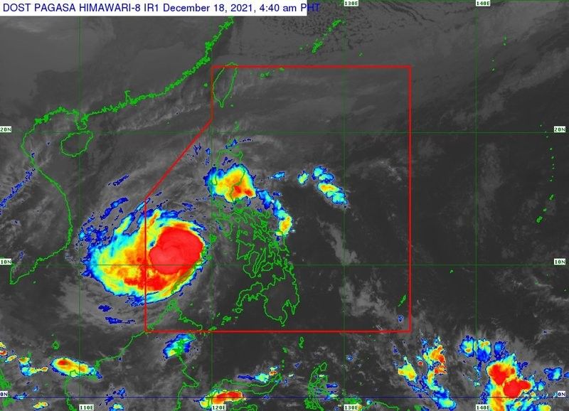
Odette, the strongest typhoon to batter the disaster-prone Philippines this year, was last seen 380 km West Northwest of Puerto Princesa City, Palawan or 155 km East of Pag-asa Island, Kalayaan, Palawan, at 10:00 a.m.
The typhoon has slightly intensified with maximum sustained winds of 155 kilometers per hour near the center, gustiness of up to 190 km/h, and a central pressure of 955 hectoPascals.
Odette is heading west northward at 25 kph and is forecast to pass in the vicinity of Kalayaan Islands within the day. It is also expected to exit the Philippine Area of Responsibility this morning or this afternoon.
The state weather bureau raised Tropical Cyclone Wind Signals over the following areas:
TCWS No. 3 (Destructive typhoon-force winds prevailing or expected within 18 hours)
- Kalayaan Islands
“Destructive typhoon-force winds will be experienced within any of the areas where TCWS No. 3 is in effect. This may bring moderate to heavy damage to structures and vegetation,” PAGASA said.
TCWS No. 1 (Strong winds prevailing or expected within 36 hours)
- The western portion of Palawan (San Vicente, Puerto Princesa City, Aborlan, Quezon, Rizal, Taytay, El Nido)
"Strong winds (strong breeze to near gale) with higher gusts will be experienced within any of the areas where TCWS #1 is currently in effect during the passage of the typhoon," PAGASA said.
"This may generally bring up to very light damage to structures and vegetation."
What to expect
Heavy to torrential rains
- Kalayaan Islands
Moderate to heavy rains
- northern and eastern portions of Cagayan
- eastern portion of Isabela, Apayao, Aurora
- northern portion of Quezon including Polillo Islands
Light to moderate with at times heavy rains
- Camarines Norte
- Camarines Sur
- Catanduanes
- Nueva Vizcaya
- Quirino
- Nueva Ecija
- Northern Samar
- rest of Cagayan, Isabela and Quezon
"A slight re-intensification may take place today as [Odette] moves over the West Philippine Sea," PAGASA said. "However, the eventual exposure of the typhoon to increasing vertical wind shear and the surge of the Northeast Monsoon will result in a weakening trend beginning tomorrow."
The death toll from Odette has risen to 18 as of Saturday. The National Disaster Risk Reduction and Management Council warned of "severe damage" in the hardest-hit areas.
Track
- Saturday evening: 150 km nornthwest of Pag-asa Island, Kalayaan, Palawan (outside the PAR)
- Sunday morning: 395 km northwest of Pag-asa Island, Kalayaan, Palawan (outside the PAR)
- Sunday evening: 575 km northwest of Pag-asa Island, Kalayaan, Palawan (outside the PAR)
- Monday morning: 770 km north northwest of Pag-asa Island, Kalayaan, Palawan or 1,065 km West of Northern Luzon (outside the PAR)
- Monday evening: 1,070 km west of extreme northern Luzon (outside the PAR)
- Tuesday morning: 940 km West of Extreme Northern Luzon (outside the PAR)
— with a report from Agence France-Presse


- Latest
- Trending