


PAGASA: ‘Rolly’ may become a super typhoon in 12 hours
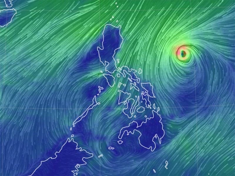
MANILA, Philippines — Typhoon “Rolly,” the strongest storm on earth so far this year, may strengthen into a super typhoon in the next 12 hours, PAGASA warned Saturday.
“Owing to very favorable conditions, there remains a possibility that this typhoon will reach super typhoon category over the next 12 hours,” the state weather bureau said in its 8 a.m. bulletin. A storm is classified as a super typhoon once its winds reach 220 kilometers per hour (kph).
But the state weather bureau said that it is more likely that “Rolly” is near super typhoon strength, packing winds between 185 to 215 kph, by the time it grazes Bicol region and makes landfall over Quezon Sunday afternoon or early evening.
“Rolly,” which was last spotted 540 kilometers east northeast of Virac, Catanduanes, currently packs winds of up to 215 kph near the center and gusts of up to 265 kph. It is moving westward at 20 kph.
Storm warning signal number 2 has been hoisted over the following areas, where winds of 61 to 120 kph and intermittent rains may be expected in at least 36 hours:
- Catanduanes
- Camarines Norte
- Camarines Sur
- Albay
- Sorsogon
- Burias Island
- San Francisco, Quezon
- San Andres, Quezon
- San Narcisco, Quezon
- Mulanay, Quezon
- Catanauan, Quezon
- Buenavista, Quezon
- Lopez, Quezon
- Guinayangan, Quezon
- Calauag, Quezon
- Tagkawayan, Quezon
Meanwhile, storm signal number 1 has been raised over the following areas:
- Metro Manila
- The rest of Masbate including Ticao Island
- The rest of Quezon including Polillo Islands
- Rizal
- Laguna
- Cavite
- Batangas
- Marinduque
- Romblon
- Occidental Mindoro including Lubang Island
- Oriental Mindoro
- Bulacan
- Pampanga
- Bataan
- Zambales
- Tarlac
- Nueva Ecija
- Aurora
- Pangasinan
- La Union
- Benguet
- Ifugao
- Nueva Vizcaya
- Quirino
- Aurora, Isabela
- Luna, Isabela
- Reina Mercedes, Isabela
- Naguilian, Isabela
- Benito Soliven, Isabela
- San Mariano, Isabela
- Palanan, Isabela
- Dinapigue, Isabela
- San Guillermo, Isabela
- Echague, Isabela
- San Agustin, Isabela
- Jones, Isabela
- Cordon, Isabela
- Santiago City, Isabela
- Ramon, Isabela
- San Isidro, Isabela
- Angadanan, Isabela
- Alicia, Isabela
- Cauayan City, Isabela
- Cabatuan, Isabela
- San Mateo, Isabela
- Northern Samar
- Tagapul-An, Samar
- Almagro, Samar
- Santo Nino, Samar
- Tarangnan, Samar
- Catbalogan City, Samar
- Calbayog City, Samar
- Santa Margarita, Samar
- Gandara, Samar
- Pagsanghan, Samar
- San Jorge, Samar
- Jiabong, Samar
- Motiong, Samar
- Paranas, Samar
- San Jose de Buan, Samar
- Matuguinao, Samar
- Taft, Eastern Samar
- Can-Avid, Eastern Samar
- Dolores, Eastern Samar
- Maslog, Eastern Samar
- Jipapad, Eastern Samar
- Arteche, Eastern Samar
- Oras, Eastern Samar
- San Policarpo, Eastern Samar
- Kawayan, Biliran
- Maripipi, Biliran
Signal Number 3 may be raised over portions of the Bicol region later today, PAGASA said.
PAGASA forecasts that the eye of the typhoon will pass very close to Catanduanes early Sunday morning, over Calaguas Islands. It will then pass very close to mainland Camarines provinces, over Polillo Islands and mainland Quezon.
A landfall over Catanduanes is not yet ruled out due to the proximity of the forecast track to the Bicol region.
The state weather bureau is warning of “violent winds and intense rainfall” over Catanduanes, Camarines Norte, and the northern portion of Camarines Sur beginning early Sunday morning until afternoon.
The same conditions are expected over Quezon and the southern portion of Aurora beginning Sunday afternoon until evening.
Heavy to intense rains are expected beginning this evening until tomorrow over Catanduanes, Camarines Norte, Camarines Sur, Albay, Burias Island, Calabarzon, Metro Manila, Bulacan, Pampanga, Bataan, Zambales and Tarlac.
Meanwhile, moderate to heavy rains will be experienced over Marinduque, Romblon, Occidental Mindoro, Oriental Mindoro, Northern Samar, mainland Cagayan Valley, and the rest of Bicol region and central Luzon.
PAGASA also warned that in the next 48 hours there is a “moderate to high risk” of a storm surge of up to three meters over the northern coastal areas of Quezon including Polillo Islands, and up to two meters over the coastal areas of Aurora, Marinduque, Bicol Region, and Northern Samar and the other coastal areas of Quezon.


- Latest
- Trending


