After lashing southern Luzon, 'Quinta' to emerge over West Philippine Sea
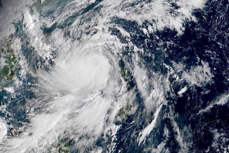
MANILA, Philippines (Updated 9:54 a.m.) — Typhoon Quinta (international name: Molave) is forecast to emerge over the West Philippine Sea within the next hour after barreling across Luzon, weather forecasters said Monday morning.
In its 8 a.m. bulletin, PAGASA said “Quinta” is expected to maintain its typhoon category as it crosses Mindoro Island. After emerging over the West Philippine Sea, it is forecast to re-intensify and may reach peak intensity within 24 to 48 hours.
The eye of the typhoon was last seen in the vicinity of Mamburao in Occidental Mindoro. It previously made five landfalls in San Miguel Island and Malinao in Albay, San Andres in Queon, Torrijos in Marinduque and Pola in Oriental Mindoro.
It is packing peak winds of 125 kilometers per hour near the center and gust of up to 180 kph. Moving west at 25 kph, “Quinta” is forecast to exit the Philippine Area of Responsibility Tuesday morning.
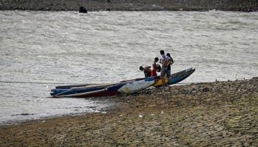
The typhoon’s frequent rains and strong winds forced thousands of families in Southern Luzon to flee their homes amid the threat of COVID-19. “Quinta” also prompted several local government units to suspend classes.
Tropical Cyclone Wind Signal No. 3 over the following areas:
- Southern portion of Batangas (Lian, Tuy, San Juan, Rosario, Padre Garcia, Lipa City, Cuenca, San Jose, Ibaan, Taysan, Lobo, Batangas City, Mabini, Tingloy, San Pascual, Bauan, Alitagtag, San Luis, Taal, Santa Teresita, Calatagan, Balayan, Calaca, Lemery, Agoncillo, San Nicolas, Mataas Na Kahoy)
- Northern and central portion of Oriental Mindoro (Mansalay, Roxas, Bongabong, Bansud, Gloria, Pinamalayan, Pola, Socorro, Victoria, Naujan, Calapan City, Baco, San Teodoro, Puerto Galera)
- Northern and central portion of Occidental Mindoro (San Jose, Rizal, Calintaan, Sablayan, Santa Cruz, Mamburao, Paluan, Abra de Ilog) including Lubang Island
Winds between 121 kph and 170 kph may be experienced in these areas in at least 18 hours.
TCWS No. 2, meanwhile, is raised over:
- Quezon
- Rizal
- Laguna
- Rest of Batangas
- Cavite
- Metro Manila
- Southern portion of Bulacan (Norzagaray, Angat, San Rafael, Baliuag, Pulilan, Calumpit, Hagonoy, Paombong, Malolos City, Plaridel, Bustos, San Jose del Monte City, Santa Maria, Pandi, Guiguinto, Balagtas, Bulacan, Bocaue, Meycauayan City, Obando, Marilao)
- Southern portion of Pampanga (Lubao, Sasmuan, Macabebe, Masantol, Minalin, Apalit)
- Bataan
- Marinduque
- Northern portion of Romblon (Concepcion, Banton, Corcuera, Romblon, San Agustin, Calatrava, San Andres, Odiongan, Santa Maria)
- Rest of Oriental Mindoro
- Rest of Occidental Mindoro
- Calamian Islands
- Extreme northern portion of Antique (Caluya)
Winds between 61 kph and 120 kph may affect these areas in at least 24 hours.
TCWS No. 1 is up over:
- Camarines Norte
- Western portion of Camarines Sur (Siruma, Tinambac, Calabanga, Naga City, Pili, Bula, Balatan, Minalabac, Milaor, Bombon, Magarao, Canaman, Camaligan, Gainza, San Fernando, Pasacao, Pamplona, Cabusao, Libmanan, Sipocot, Lupi, Ragay, Del Gallego)
- Burias Island
- Rest of Romblon
- Northern portion of Palawan (El Nido, Taytay) including Cuyo Islands
- Southern portion of Aurora (Dingalan, San Luis)
- Southern portion of Nueva Ecija (Gabaldon, Laur, Palayan City, General Tinio, Cabanatuan City, Aliaga, Zaragoza, Jaen, San Antonio, Santa Rosa, Peñaranda, Gapan City, San Leonardo, San Isidro, Cabiao)
- Southern portion of Tarlac (La Paz, Tarlac City, San Jose, Concepcion, Capas, Bamban)
- Rest of Bulacan
- Rest of Pampanga
- Central and southern portion of Zambales (Iba, Botolan, Cabangan, San Felipe, San Narciso, San Antonio, San Marcelino, Castillejos, Subic, Olongapo City)
- Aklan
- Rest of the northern portion of Antique (Laua-An, Barbaza, Tibiao, Culasi, Sebaste, Pandan, Libertad)
Wind between 30 and 60 kph may prevail in areas under TCWS No. 1 in at least 36 hours.
Hazards affecting land, coastal waters
PAGASA said Quinta” will bring moderate to heavy at times intense rains over:
- Occidental Mindoro
- Oriental Mindoro
- Romblon,
- Marinduque
- Northern Palawan including Calamian and Cuyo Islands
- CALABARZON
- Aurora
- Isabela
- Aklan
- Capiz
- Antique.
The tail-end of a frontal system, meanwhile, will bring moderate to heavy rains over:
- Cagayan
- Apayao
- Kalinga
- Abra
- Ilocos Norte
- Ilocos Sur
“Quinta” and the tail-end of a frontal system are expected to dump light to moderate with at times heavy rains over:
- Metro Manila
- Zamboanga Peninsula
- Bangsamoro
- Northern Mindanao
- Caraga
- Rest of Luzon
- Rest of Visayas
PAGASA also said that “destructive typhoon-force winds” will be experienced in areas under TCWS No. 3, “damaging gale to storm-force winds” in areas under TCWS No. 2 and “strong breeze to near gale conditions” in areas under TCWS No. 1.
“In other areas, strong breeze to gale conditions due to the northeasterly surge will also prevail over Ilocos Region, Batanes, Cagayan, Apayao, and northern Zambales,” it said.
The state weather bureau also warned that a storm surge of 2 to 3 meters may be experienced in the coastal areas of Camarines Norte, and the northern coastal areas of Quezon including Polillo Islands and Camarines Sur and 1 to 2 m in the coastal areas of Batangas, Marinduque, Occidental Mindoro, Oriental Mindoro, Romblon, and the remaining coastal areas of Quezon and Camarines Sur.
Sea travel is risky for all types of sea vessels over the areas under wind signals due to “rough to high seas”and the remaining seaboards of Luzon and the western, northern, and eastern seaboards of Visayas because of “rough to very rough seas.”
“Moderate to rough seas” will be experienced over the other seaboards of the country Monday.
Mark Timbal, National Disaster Risk Reduction Management Council spokesperson, said that 2,475 families or 9,235 people were affected by “Quinta” in Calabarzon, Mimaropa, Bicol region and Cordillera Administrative Region. Of the figure, 1,503 households or 5,704 persons are staying in evacuation centers.
He added the agency is looking into the report that 12 people were missing in Catanduanes.
Power interruptions were also experienced in Quezon province, Albay, Catanduanes, Camarines Sur, Masbate and Sorsogon.
Forecast positions
- Tuesday morning: 495 km west of Calapan City, Oriental Mindoro
- Wednesday morning: 1,015 km west of Southern Luzon (outside PAR)
— Gaea Katreena Cabico


- Latest
- Trending