


‘Tisoy’ weakens anew after 4th landfall over Mindoro
MANILA, Philippines — Typhoon Tisoy (international name: Kammuri) has weakened further after hitting land for the fourth time, state weather bureau PAGASA said Tuesday afternoon.
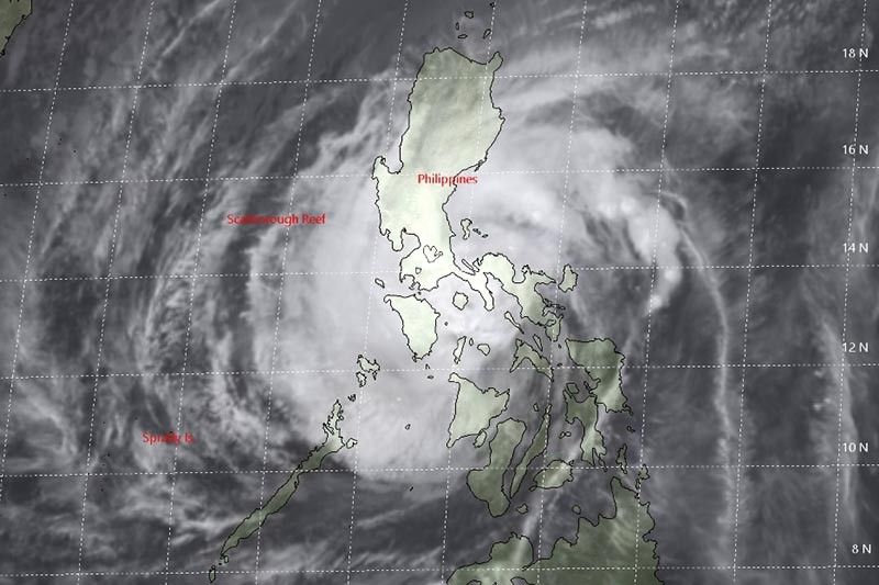
The typhoon made its fourth landfall over the northern town of Naujan in Oriental Mindoro at 12:30 p.m. It previously hit the lands of Sorsogon, Masbate and Marinduque.
“Tisoy”—traversing the northern portions of Mindoro provinces—was last seen in the vicinity of Baco, Oriental Mindoro. It is heading west at 25 kph.
It now packs maximum sustained winds of 140 kph from the previous 155 kph. The typhoon’s gusts also weakened to 195 kph from the previous 205 kph.
“Technically, malakas pa rin ang hangin na dala nito,” weather specialist Benison Estareja said.
The typhoon is projected to be over the West Philippine Sea by evening and outside the Philippine area of responsibility on Thursday.
“Tisoy” lashed southern Luzon and parts of Visayas with fierce winds and heavy rains, toppling trees and power poles and forcing the evacuation of hundreds of thousands from their homes.
The typhoon also prompted suspensions of classes and work and cancellation of hundreds of domestic and international flights.
Frequent to continuous heavy to intense rains are expected to prevail over Romblon, Mindoro provinces and Calabarzon until late Tuesday afternoon.
Meanwhile, there will be occasional to frequent heavy rains over Metro Manila, Bicol region and Central Luzon, and intermittent heavy rains over Aklan, Antique, Capiz and northern portions of Negros provinces.
Between late Tuesday afternoon and Wednesday morning, residents of Mindoro provinces, Metro Manila, Central Luzon, Rizal and northern Quezon including Polillo Islands will have frequent to continuous heavy (with isolated intense) rains.
“Tisoy” will also bring occasional heavy rains over Cagayan Valley, Cordillera Administrative Region, Marinduque, Romblon and the rest of Calabarzon and intermittent heavy rains over Calamian Islands between late Tuesday afternoon and Wednesday morning.
PAGASA lifted Tropical Cyclone Warning Signals over Ilocos Sur, Biliran, parts of northern Samar and Negros Occidental, Guimaras and Leyte. Storm signals, however, remain hoisted over the following areas:
TCWS No. 3 (Winds between 121 kph and 170 kph in at least 18 hours)
- Southern portion of Quezon (Sampaloc, Lucban, Tayabas, Pagbilao, Lucena, Sariaya, Candelaria, Dolores, Tiaong, San Antonio)
- Marinduque
- Oriental Mindoro
- Occidental Mindoro including Lubang Island
- Batangas
- Cavite and Laguna
TCWS No. 2 (Winds between 61 kph and 120 kph in at least 24 hours)
- Burias Island
- Romblon
- Northern portion of Camarines Sur (Cabugao, Libmanan, Pamplona, Pasacao, Sipocot, Lupi, Ragay, Del Gallego)
- Camarines Norte
- Metro Manila
- Bulacan
- Bataan
- Tarlac
- Pampanga
- Nueva Ecija
- Southern Aurora (Dipaculao, Maria Aurora, Baler, San Luis, Dingalan)
- Rizal
- Rest of Quezon including Polillo Islands
- Calamian Islands (Coron, Busuanga, Culion, Linapacan)
- Zambales
- Pangasinan
TCWS No. 1 (Winds between 30 kph and 60 kph in at least 36 hours)
- Southern Isabela (Palanan, Dinapigue, San Mariano, San Guillermo, Benito Soliven, Naguilian, Reina Mercedes, Luna, Aurora, Cabatuan, San Mateo, Cauayan City, Alicia, Angadanan, Ramon, San Isidro, Echague, Cordon, Santiago City, Jones and San Agustin)
- Benguet
- Nueva Vizcaya
- La Union
- Quirino
- Rest of Aurora
- Northern portion of Palawa (El Nido, Taytay, Araceli, Dumaran)
- Rest of Camarines Sur
- Cuyo Islands (Cuyo, Magsaysay, Agutaya)
- Masbate including Ticao Island
- Albay
- Sorsogon
- Catanduanes
- Western portion of Northern Samar (Capal, San Antonio, San Vicente, Lavezares, Allen, Biri, Rosario, Victoria, San Jose, San Isidro, Bobon, Catarman, Lope de Vega)
- Northwestern portion of Samar (Calbayog, Tagapul-am, Almagro)
- Capiz
- Iloilo
- Rest of Aklan
- Rest of Antique
Weather forecasters warned there could be storm surges of up to three meters over the coastal areas of Marinduque, Mindoro provinces, Cavite, Romblon and Batangas.
Sea travel remains risky over the seaboards of areas under TCWS, seaboards of northern Luzon, western seaboard of Palawan, the seaboards of Visayas, and the northern and eastern seaboards of Mindanao.
Forecast positions
- Wednesday morning: 335 km west of Subic, Zambales
- Thursday morning: 670 km west of Subic, Zambales (outside PAR)
- Friday morning: 745 km west of Coron, Palawan (outside PAR)


- Latest
- Trending


