


Now outside Luzon, Paeng weakens into tropical storm
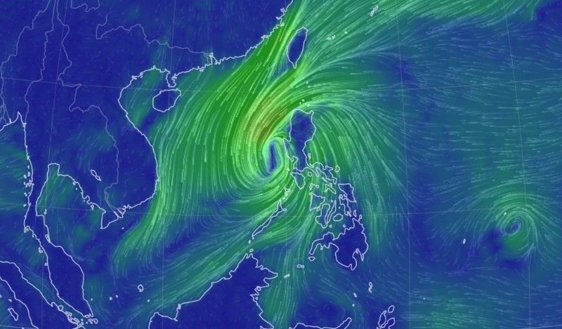
MANILA, Philippines — Destructive cyclone Paeng, now a tropical storm, has weakened as it passed over the vicinity of Candelaria in Zambales and located west northwest of Iba, Zambales early Sunday morning.
State weather bureau PAGASA, in its 5 a.m. bulletin, reported that the weakened storm was already over the West Philippine Sea.
Having triggered flooding across Luzon, the cyclone packed sustained winds of 85 kph near the center and gusts of up to 105 kph.
Signal No. 3 was lifted while other areas on the storm's track are still warned of strong winds.
Signal No. 2
Winds of greater than 62 km/h and up to 88 km/h may be expected in at least 24 hours.
- Pangasinan
- La Union
- Southern portion of Ilocos Sur (City of Candon, Banayoyo, Galimuyod, Sigay, Suyo, Santa Lucia, Santa Cruz, Alilem, Tagudin, Sugpon, Cervantes, Quirino, Gregorio del Pilar, Salcedo, Lidlidda, San Emilio, Santiago, Burgos, Santa Maria, San Esteban), Benguet, Tarlac, Zambales, the western portion of Bataan (Morong, Bagac, Dinalupihan, Hermosa)
- Western portion of Pampanga (Floridablanca, Mabalacat City, Magalang, Angeles City, Porac)
- Northwestern portion of Nueva Ecija (Guimba, Cuyapo, Talugtug, Nampicuan)
PAGASA warns that winds reaching gale-force strength may still be experienced in any of the areas where Wind Signal No. 2 is in effect.
Signal No. 1
Winds of 39-61 km/h may be expected in at least 36 hours or intermittent rains may be expected within 36 hours.
- Cagayan including Babuyan Islands
- Isabela
- Quirino
- Nueva Vizcaya
- Apayao
- Kalinga
- Ifugao
- Mountain Province
- Abra
- Ilocos Norte
- The rest of Ilocos Sur
- Aurora
- The rest of Nueva Ecija
- The rest of Pampanga
- Bulacan
- The rest of Bataan
- Metro Manila
- Laguna
- Rizal
- Batangas
- Cavite
- Quezon including Pollilo Islands
- Marinduque
- Northwestern portion of Romblon (Concepcion, Banton, Corcuera)
- Occidental Mindoro including Lubang Islands
- Oriental Mindoro
- Calamian Islands
- Camarines Norte
- Northwestern portion of Camarines Sur (Lupi, Ragay, Del Gallego, Sipocot)
What will the weather be like in the morning?
- Moderate to heavy rains are likely over Zambales, Bataan, Aurora, Pangasinan, Batanes, and the northern portion of Cagayan including Babuyan Islands.
- Light to moderate with at times heavy rains possible over Metro Manila, Cordillera Administrative Region, CALABARZON, MIMARPOPA, Camarines Provinces, Western Visayas, and the rest of Cagayan Valley and Central Luzon.
Areas under Wind Signal No.1 may experience strong winds (strong breeze to near gale strength) throughout the passage of the tropical cyclone.
How about flooding?
"Except in areas with significant antecedent rainfall or those still experiencing persistent heavy rainfall, flooding and rain-induced landslides are likely to slowly subside," PAGASA notes.
Where will Paeng be?
On PAGASA's forecast track, Paeng is moving westward until Sunday afternoon before turning north northwestward.
It will likely maintain its north northwestward direction till Sunday night through Tuesday, then turn northwestward on Wednesday as it moves closer to southern China.
Paeng will likely exit the Philippine Area of Responsibility on Monday morning or afternoon.


- Latest
- Trending


