Champi reintensifies as super typhoon
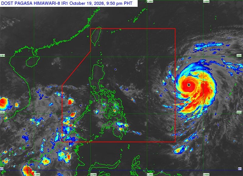
MANILA, Philippines — The super typhoon outside the Philippine area of responsibility (PAR), with the international name Champi, reintensified into a super typhoon yesterday, according to the Philippine Atmospheric, Geophysical and Astronomical Services Administration (PAGASA).
Champi, which will be given the local name Rosal when it enters PAR today, will bring rains as early as today in the southern parts of the Philippines and will intensify in the northern parts of the country by the rest of the week.
As of 5 p.m. yesterday, PAGASA said Champi was located 1,515 kilometers east of southeastern Luzon, packing winds of 185 kms per hour and gusts of 230 kph.
The state weather bureau said Champi will maintain its strength as a super typhoon as it enters PAR this morning or early afternoon. However, a gradual weakening may start on Thursday after it reaches its peak intensity.
PAGASA said the super typhoon will continue to move west-northwestward until tomorrow before moving generally northwestward by Thursday.
State meteorologists said wind signals may be hoisted over the northern and eastern portions of Northern Luzon and portions of the Bicol Region today.
“The highest wind signal for the current forecast scenario is Wind Signal No. 2 or 3,” PAGASA said.
Most parts of Luzon and the Visayas and portions of Mindanao may have gusty conditions starting tomorrow.
Heavy rains may be experienced in extreme northern Luzon, PAGASA said.
They warned that moderate to rough seas may be experienced over the northern and eastern seaboards of Luzon and the eastern seaboards of the Visayas and Mindanao today.
“Hazardous sea conditions, reaching very rough, high or very high seas, may affect the northern and eastern seaboards of Luzon by Wednesday onwards,” PAGASA said.
Champi is expected to exit PAR on Saturday, PAGASA added.
Meanwhile, the intertropical convergence zone may bring cloudy skies with scattered rains and thunderstorms in the Zamboanga Peninsula and Palawan.
Champi’s trough may cause cloudy skies with scattered rains and thunderstorms in Catanduanes, Northern Samar and Eastern Samar.
Partly cloudy to cloudy skies with isolated rainshowers or thunderstorms will be experienced in Cagayan Valley, the Cordillera Administrative Region and Ilocos Region due to the easterlies.
Metro Manila and the rest of the country will have partly cloudy to cloudy skies with isolated rainshowers or thunderstorms brought by localized thunderstorms. — Emmanuel Tupas








- Latest
- Trending