Over 20 areas under Signal No. 1 as 'Lannie' hits Surigao del Norte, Dinagat Islands
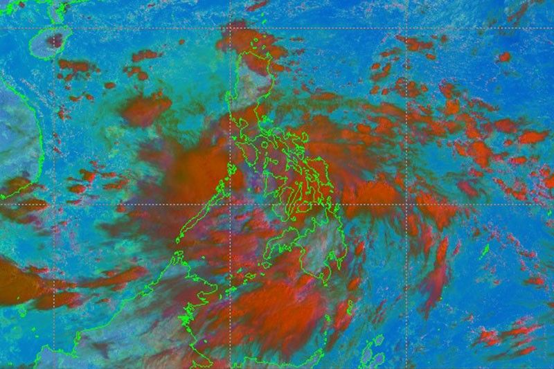
MANILA, Philippines — State weather forecasters on Monday morning said Tropical Depression Lannie made two landfalls in Surigao del Norte and Dinagat Islands.
Pagasa also hoisted Tropical Cyclone Wind Signal No. 1 over 24 areas across the country as Lannie traverses central Philippines.
In its 8:00 a.m. bulletin on Monday, PAGASA located Lannie over the coastal waters of Liloan, Southern Leyte as of 7:00 a.m. It added that Lannie is about to make its third landfall over in Surigao Strait in Southern Leyte.
Lannie packs maximum sustained winds of 45 kph near the center, with gustiness of up to 55 kph. The tropical depression continues moving west northward at 15 kph.
Pagasa said Lannie made landfall in Bucas Grande Island, Socorro, Surigao del Norte at 4:30 a.m. and Cagdianao, Dinagat Islands at 5:00 a.m.
The following areas have been placed under Signal No. 1:
Visayas
- Eastern Samar
- Samar
- Biliran
- Leyte
- Southern Leyte
- Capiz
- Aklan
- Antique
- Iloilo
- Guimaras
- Negros Occidental
- Northern and Cental poritions of Negros Oriental (Bais City, Mabinay, City of Bayawan, Basay, City of Tanjay, Manjuyod, Bindoy, Ayungon, Tayasan, Jimalaud, La Libertad, City of Guihulngan, Vallehermoso, Canlaon City)
- Cebu
- Bohol
Mindanao
- Surigao del Norte
- Dinagat islands
- Northern portion of Agusan del Norte (Magallanes, Remedios T. Romualdez, City of Cabadbaran, Tubay, Santiago, Jabonga, Kitcharao, Butuan City)
- Northern portion of Agusan del Sur (Sibagat, City of Bayugan, Prosperidad)
- Northern portion of Surigao del Sur (San Miguel, Marihatag, San Augustin, Cagwait, Bayabas, Tago, City of Tandag, Cortes, Lanuza, Carmen, Madrid, Cantilan, Carrascal, Lianga)
Lannie is forecasted to move generally west northwestward over the Visayas archipelago until Monday evening or early Tuesday morning, when it is expected to emerge over at the Sulu Sea and cross Cuyo Archipelago.
PAGASA added that Lannie may make another landfall in northern Palawan area or Calamian Islands on Tuesday morning before emerging over the West Philippine Sea.
Lannie is also seen to remain as tropical depression over the period of its traverse in central Philippines, with possibility of slight intensification when it reaches Sulu Sea or West Philippine Sea.
The state weather bureau added that Lannie is forecast to move generally northwestward over the West Philippine Sea by late Tuesday until early Thursday. “Improvement in environmental conditions will allow the depression to intensify,” it added.
By Wednesday early morning, Lannie may intensify to tropical storm category.
Lannie is seen to exit the Philippine Area of Responsibility on Thursday morning.
The state weather bureau advised public and disaster risk reduction and management offices to take all necessary measures to protect life and liberty, while persons living in areas identified to be susceptible to these hazards are urged to follow evacuation and other instructions from local officials.
Heavy rainfall
PAGASA said Visayas, Bicol Region, Mimaropa, Calabarzon and Caraga Region are likely to experience moderate to heavy with at times intense rains on Monday until Tuesday morning.
Light to moderate with at times heavy rains may be expected in Metro Manila, Bulacan, Bataan and the rest of Mindanao.
In the National Capital Region, the Commission on Elections is holding the filing of certificates of candidacy for national posts at tent in Sofitel in Pasay City.
“Under these conditions, scattered flooding (including flash floods) and rain-induced landslides are possible especially in areas that are highly or very highly susceptible to these hazard as identified in hazard maps,” PAGASA added.
Strong winds with occasional gusts will also be experienced in areas under Signal No. 1, and these may cause “very light damage to structures and vegetation,” it added.
“The enhanced easterly flow north of the tropical depression may also bring occasionally gusts and reaching strong breeze to near gale in strength over Extreme Northern Luzon and the coastal and upland/mountainous areas of the eastern section of Luzon in the next 24 hours,” PAGASA also said.
Forecast position
- Monday 5:00 p.m.: Over the coastal waters of Jordan, Guimaras
- Tuesday 5 a.m.: Over the coastal waters of Linapacan, Palawan
- Tuesday, 5 p.m.: 200 km west of Coron, Palawan
- Wednesday 5 a.m.: 465 west of Calapan City, Oriental Mindoro
- Wednesday 5 p.m.: 495 km west of Subic Bay
- Thursday 5 a.m.: 505 km west of Iba, Zambales (outside of Philippine area of responsibility)
- Friday 5 a.m.: 560 km west of Sinait, Ilocos Sur (outside PAR)
- Saturday 5 a.m. 745 km west of Calayan, Cagayan (outside PAR)
— Kristine Joy Patag
Follow this page for updates on Lannie, the 11th tropical cyclone to enter the Philippines on 2021. — Main photo from JTWC
Tropical Depression Lannie left the Philippine Area of Responsibility at 5 a.m., PAGASA weather specialist Ariel Rojas says in an interview with ANC.
However, it will still bring cloudy skies with scattered rains in Metro Manila, Central Luzon, Calabarzon and Mimaropa.
Tropical Depression Lannie is forecast to exit the Philippine Area of Responsibility on Wednesday morning.
State weather bureau PAGASA says the trough of the weather disturbance may bring rains over the western section of Mimaropa.
At 4 a.m., Lannie was located 670 km west of Calapan City, Oriental Mindoro with winds of 45 kh and gustiness of 55 kph. It is moving west northwestward at 25 kph.
All tropical cyclone warning signals have been lifted as Tropical Depression Lannie moves over the West Philippine Sea.
At 10 a.m., Lannie was located 165 km west of Coron, Palawan, packing maximum winds of 45 kph and gusts of up to 55 kph. It is moving west northwestward at 25 kph.
State weather bureau PAGASA says Lannie will exit the Philippine Area of Responsibility by Wednesday afternoon or evening.
Signal No. 1 is still up over the northern portion of Palawan (El Nido, Taytay, Dumaran, Araceli) including Calamian Islands due to Tropical Depression Lannie.
At 7 a.m., Lannie was located over the coastal waters of El Nido, Palawan with winds of 45 kph and gustiness of 55 kph. It is moving northwestward at 25 kph.
PAGASA says Lannie will continue tracking northwestward and west northwestward over the West Philippine Sea away from the country until tomorrow.
Tropical Depression Lannie is seen to make another landfall in the vicinity of northern mainland Palawan or Calamian Islands on Tuesday morning, state weather bureau PAGASA says.
At 4 a.m., Lannie was located 90 km northwest of Cuyo, Palawan or 70 km south southeast of Coron, Palawan winds of 45 kph and gustiness of 55 kph.
Signal No. 1 is raised over the southwestern portion of Romblon (Odiongan, Looc, Alcantara, Ferrol, Santa Fe, San Jose), the southern portion of Oriental Mindoro (Roxas, Mansalay, Bulalacao), the southern portion of Occidental Mindoro (Calintaan, Rizal, San Jose, Magsaysay), and the northern portion of Palawan (El Nido, Taytay, Dumaran, Araceli) including Calamian and Cuyo Islands, Antique and the western portion of Aklan (Madalag, Malinao, Ibajay, Nabas, Malay, Buruanga).


- Latest
- Trending