


'Jolina' seen to make landfall over Northern Luzon on Thursday — PAGASA
MANILA, Philippines — Tropical Depression "Jolina" slightly intensified and is seen to make landfall on Thursday, PAGASA said.
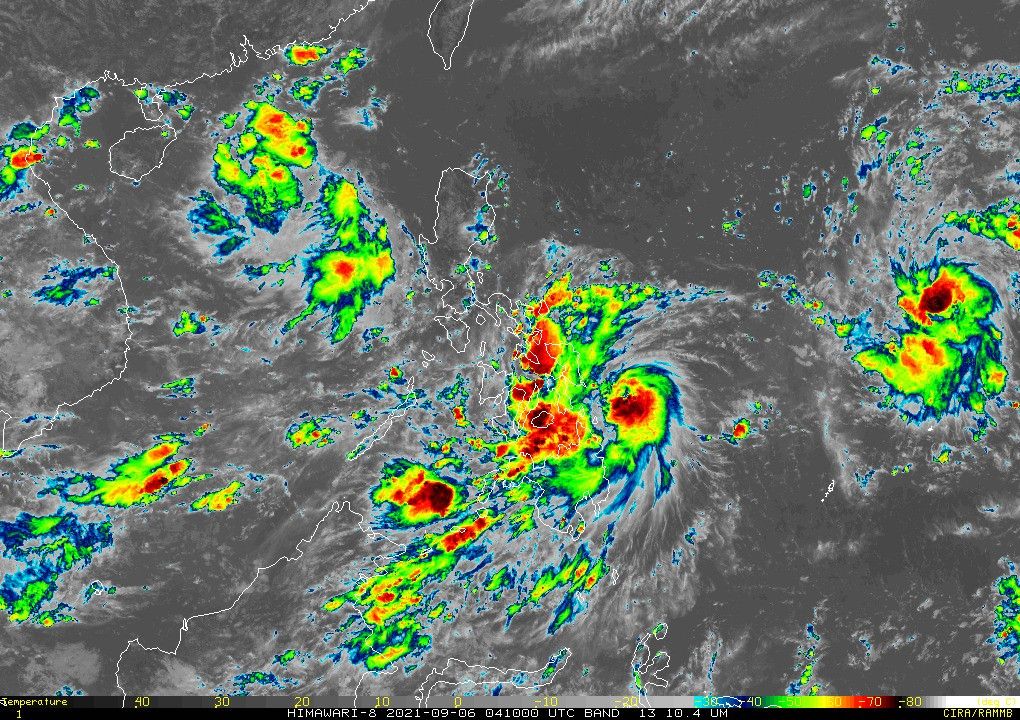
The agency in its latest bulletin said the weather disturbance was last seen at 205 kilometers east southeast of Guiuan in Eastern Samar.
It now packs 55 kilometers per hour, peak winds and gusts of up to 70 kph. Jolina moves westward at a speed of 15 kph.
PAGASA said Jolina is forecast to become a tropical storm on Wednesday, and make landfall over Northern Luzon on Thursday.
It will return to tropical depression status as it moves over the rugged terrain of the area, and is seen to exit the Philippine Area of Responsibility on Friday.
"However, the public is advised to continue monitoring for possible changes in the track forecast in the succeeding bulletins," the agency added.
These areas remain under Signal No. 1 as of 11 a.m. of September 6:
- Sorsogon
- Northern Samar
- Samar
- Eastern Samar
- Dinagat Islands
- Siargao Islands
- Bucas Grande Islands
Weather forecasters added Jolina would bring moderate to heavy rains in the next 24 hours over Eastern Samar, Dinagat Islands, Surigao del Norte including Siargao, as well as Bucas Grande Islands.
Northern Cebu, Bohol, Camiguin, and the rest of Eastern Visayas, meanwhile, would experience light to moderate with ocassional heavy rains.
"Under these conditions, isolated to scattered flash flooding and rain-induced landslides are possible," PAGASA said, "especially in areas that are highly or very highly susceptible to these hazard as identified in hazard maps."
On coastal waters, Jolina is seen to bring moderate to rough seas over the eastern seaboards of Visayas and Mindanao.
PAGASA also advised small seacrafts to take precautionary areas when out in the sea, while inexperienced mariners were warned against navigating in the said conditions.
Jolina is the 10th storm to enter the Philippines this year. Last week, the agency said two to three storms are expected inside the country this September.
Forecast Position:
- Tuesday morning: 185 km east southeast of Catarman, Northern Samar
- Wednesday morning: 180 km east of Daet, Camarines Norte
- Thursday morning: In the vicinity of San Mariano, Isabela
- Friday morning: 330 km west of Sinait, Ilocos Sur
— Christian Deiparine

Follow this page for updates on Jolina, the tenth tropical cyclone to enter the Philippines on 2021. — Main photo from JTWC
Typhoon Kiko slightly weakens as it moves towards the Babuyan Islands-Batanes area, state weather bureau PAGASA says on Friday morning.
At 4 a.m., Kiko was located 280 km east northeast of Casiguran, Aurora with winds of 185 kph and gustiness of 230 kph.
Tropical cyclone wind signals are raised in the following areas:
Signal No. 3
- the extreme northeastern portion of Cagayan (Santa Ana)
Signal No. 2
- Batanes
- Babuyan Islands
- the remaining eastern portion of mainland Cagayan (Aparri, Camalaniugan, Lal-Lo, Gattaran, Baggao, Peñablanca, Buguey, Santa Teresita, Gonzaga)
- the northeastern portion of Isabela (San Pablo, Maconacon, Divilacan, Palanan)
Signal No. 1
- the rest of mainland Cagayan
- the northeastern portion of Ilocos Norte (Pagudpud, Adams, Dumalneg, Bangui, Vintar, Carasi)
- Apayao
- the eastern portion of Kalinga (City of Tabuk, Pinukpuk, Rizal)
- the northwestern and southeastern portions of Isabela (Santa Maria, Quezon, Mallig, Roxas, San Manuel, Cabatuan, Aurora, City of Cauayan, Angadanan, San Guillermo, Dinapigue, San Mariano, Cabagan, Santo Tomas, Delfin Albano, Tumauini, Quirino, Burgos, Gamu, Ilagan City, Luna, Reina Mercedes, Naguilian, Benito Soliven)
- the northern portion of Aurora (Dilasag, Casiguran)
All tropical cyclone wind signals have been lifted as Tropical Storm Jolina continues to move over the West Philippine Sea, state weather bureau PAGASA says.
The tropical cyclone is forecast to exit the Philippine Area of Responsibility Thursday night.
At 10 a.m., Jolina was located 240 km west of Dagupan City, Pangasinan with winds of 85 kph and gustiness of 115 kph. It is moving west ward at 10 kph.
Severe Tropical Storm Jolina is forecast to exit the Philippine Area of Responsibility by Thursday afternoon or evening, state weather bureau PAGASA says.
At 4 a.m., Jolina was located 145 km west northwest of Iba, Zambales or 175 km west of Dagupan City, Pangasinan with winds of 85 kph and gustiness of 5 kph.
Tropical cyclone wind signal no. 1 is hoisted over:
- the western portion of Pangasinan (Anda, Bolinao, Infanta, Aguilar, Sual, Labrador, Dasol, Bugallon, Burgos, Mabini, Agno, City of Alaminos, Bani, Lingayen, Mangatarem)
- the northern portion of Zambales (San Antonio, Botolan, San Narciso, San Felipe, Cabangan, Palauig, Iba, Masinloc, Candelaria, Santa Cruz)
Severe Tropical Storm Jolina continues to move northwestward crossing the Batangas-Cavite area before emerging over the mouth of Manila Bay on Wednesday afternoon or evening.
State weather bureau PAGASA says Jolina is expected to make its ninth landfall in the vicinity of Bataan Peninsula tonight.
At 2 p.m., Jolina was located in the vicinity of San Nicolas, Batangas with winds of 95 kph and gustiness of 160 kph. It is moving northwestward at 15 kph.
Tropical cyclone wind signals are up in the following areas:
Signal No. 2
- the northern and central portions of Oriental Mindoro (Bansud, Gloria, Pinamalayan, Pola, Socorro, Victoria, Puerto Galera, San Teodoro, Baco, City of Calapan, Naujan)
- the northern and central portions of Occidental Mindoro (Abra de Ilog, Paluan, Mamburao, Santa Cruz, Sablayan) including Lubang Islands
- the central portion of Quezon (Infanta, Real, Mauban, Sampaloc, Lucban, City of Tayabas, Lucena City, Sariaya, Candelaria, Dolores, Tiaong, San Antonio, Pagbilao)
- Batangas
- Cavite
- Laguna
- Rizal
- Metro Manila
- the southern portion of Bulacan (Pandi, Bulacan, Marilao, Calumpit, Norzagaray, Plaridel, Santa Maria, Balagtas, Bocaue, Bustos, City of Malolos, Angat, Obando, City of San Jose del Monte, Pulilan, City of Meycauayan, Hagonoy, Paombong, Guiguinto, San Rafael, Baliuag)
- Pampanga
- Bataan
- Zambales
- Tarlac
Signal No. 1
- Marinduque
- La Union
- the southern portion of Benguet (Sablan, Tublay, Bokod, La Trinidad, Baguio City, Itogon, Tuba, Kapangan, Atok)
- the southern portion of Nueva Vizcaya (Alfonso Castaneda, Dupax del Norte, Dupax del Sur, Aritao, Santa Fe, Kayapa)
- the southern portion of Aurora (Baler, Maria Aurora, San Luis, Dingalan)
- Pangasinan
- Nueva Ecija
- the rest of Bulaca
- the northern and southern portions of Quezon (Padre Burgos, Agdangan, Unisan, Gumaca, Atimonan, Plaridel, Pitogo, Macalelon, Quezon, Alabat, Perez, General Nakar) including Polillo Islands
- the rest of Oriental Mindoro
- the rest of Occidental Mindoro


- Latest
- Trending


