More areas under Signal No. 2 as 'Ulysses' nears typhoon level
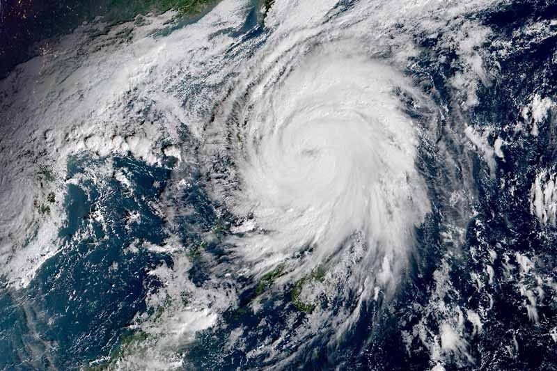
MANILA, Philippines — Severe tropical storm Ulysses (international name: Vamco) gained more strength as it continued to move closer to the Philippines and is nearing typhoon category, state weather bureau PAGASA said Wednesday morning.
The country’s 21st cyclone this year is now packing maximum sustained winds of 110 kilometers per hour near the center from the previous 100 kph and gusts of up to 135 kph from the previous 125 kph.
They eye of Ulysses was last seen 135 north northeast of Virac, Catanduanes or 350 km east of Infanta, Quezon province. The storm is moving west at 20 kph.
PAGASA hoisted storm signals over parts of Luzon and Visayas.
Tropical Cyclone Wind Signal No. 2 (Winds between 61 and 120 kph in at least 24 hours)
- Central and southern portions of Quirino (Maddela, Cabarroguis, Aglipay, Nagtipunan)
- Central and southern portions of Nueva Vizcaya (Kasibu, Bambang, Kayapa, Dupax Del Norte, Dupax Del Sur, Aritao, Santa Fe, Alfonso Castaneda)
- Southern portion of Benguet (Bokod, Itogon, Tublay, La Trinidad, Sablan, Baguio City, Tuba)
- Southern portion of La Union (Burgos, Naguilian, Bauang, Caba, Aringay, Tubao, Pugo, Santo Tomas, Rosario, Agoo)
- Pangasinan
- Zambales
- Bataan
- Tarlac
- Pampanga
- Nueva Ecija
- Aurora
- Bulacan
- Metro Manila
- Rizal
- Laguna
- Cavite
- Batangas
- Quezon including Polillo Islands
- Marinduque
- Northern portion of Occidental Mindoro (Paluan, Abra de Ilog) including Lubang Island
- Northern portion of Oriental Mindoro (Pola, Victoria, Naujan, Baco, Calapan City, San Teodoro, Puerto Galera)
- Camarines Norte
- Camarines Sur
- Albay
- Sorsogon
- Catanduanes
- Burias and Ticao Islands
TCWS No. 1 (Winds between 30 and 60 kph expected in at least 36 hours or intermittent rains within 36 hours)
- Isabela
- Rest of Quirino
- Rest of Nueva Vizcaya
- Kalinga
- Mountain Province
- Ifugao
- Rest of Benguet
- Abra
- Ilocos Sur
- Rest of La Union
- Rest of Occidental Mindoro
- Rest of Oriental Mindoro
- Romblon
- Rest of Masbate
- Northern Samar
- Northern portion of Samar (Santo Nino, Almagro, Tagapul-An, Tarangnan, Calbayog City, Santa Margarita, Gandara, Pagsanghan, San Jorge, San Jose de Buan, Matuguinao)
- Northern portion of Eastern Samar (Maslog, Dolores, Oras, San Policarpo, Arteche, Jipapad)
TCWS No. 3 may be raised over several provinces in Bicol region and eventually over Metro Manila, and portions of Calabarzon and Central Luzon once “Ulysses” reached typhoon level.
The local governments of typhoon-ravaged Catanduanes and Albay ordered mandatory evacuation of residents in vulnerable areas in preparation for the impacts of Ulysses. This, as the provinces reeled from the wrath of Super Typhoon Rolly, which damaged homes and power lines and displaced thousands of people.
Hazards
Throughout the passage of Ulysses, areas under TCWS No. 1 will be experiencing damaging gale-force to storm-force winds, while those under TCWS No. 1 will have strong breeze to near gale conditions
Residents of Camarines Norte, Camarines Sur, Catanduanes will experience heavy to intense with at times torrential rains between Wednesday morning and late afternoon. Moderate to heavy with at times intense rains will affect Albay, Sorsogon, Quezon including Polillo Islands and Burias and Ticao Islands.
Meanwhile, those living in Metro Manila and the rest of Luzon and Visayas will have light to moderate with at times heavy rains.
Between late afternoon and early morning Thursday, heavy to intense with at times torrential rains will be dumped over Camarines Norte, Camarines Sur, Metro Manila, Calabarozon, Aurora, Bulacan, Pampanga and Bataan, while moderate to heavy with at times intense rains over Cordillera Administrative Region, mainland Cagayan Valley, Catanduanes, Marinduque, northern portion of Mindoro provinces and the rest of Central Luzon.
The rest of Luzon and Visayas will have light to moderate with at times heavy rains.
PAGASA warned there is a high risk of storm surge with height up to 3 meters over the coastal areas of Quezon including Polillo Islands, Camarines Norte, Catanduanes, and the northern and eastern coastal areas of Camarines Sur.
Meanwhile, there may be storm surge of up to 2 meters over the coastal areas of Aurora, Bataan, Pampanga, Bulacan, Metro Manila, Cavite, Batangas, northern portions of Mindoro Provinces including Lubang Island, Marinduque, Romblon, Masbate including Ticao and Burias Islands, Albay, and Sorsogon, and the remaining coastal areas of Camarines Sur.
“These storm surges, which may be accompanied by swells and/or breaking waves near the coast, can cause life-threatening and damaging coastal inundation,” PAGASA said.
It added there is also a moderate risk of seiche or storm surge over the coastal areas surrounding Laguna de Bay
There will be also rough to very high seas (2.5 to 10 m) over the seaboards of areas under TCWS and the eastern seaboard of Eastern Samar currently not under TCWS No. 1.
Track and intensity
Ulysses is projected to pass over the seas north of Catanduanes between Wednesday morning and afternoon and north of Camarines Norte between this afternoon and evening. These areas may fall within the inner rainbands or eyewall region—a powerful part of a tropical cyclone—of the storm during its passage.
The center of Ulysses is forecast to make landfall over Polillo Islands and mainland Quezon between Wednesday night and early morning Thursday. Then, it will cross mainland Luzon and emerge over the western seaboard of Central Luzon between Thursday morning and afternoon.
Ulysses is expected to strengthen into a typhoon within the next six to 12 hours and reach its peak intensity of 130 to 155 kph prior to landfall. It may weaken slightly while moving over mainland Luzon due to the presence of Sierra Madre and Zambales Mountain Ranges.
“However, it is likely to remain a typhoon throughout its traverse,” PAGASA said.
Forecast positions
- Thursday morning: In the vicinity of Baliuag, Bulacan
- Friday morning: 415 km west of Iba, Zambales
- Saturday morning: 835 km west of Central Luzon (outside PAR)
- Sunday morning: 1,320 km west of Northern Luzon (outside PAR)
— Gaea Katreena Cabico


- Latest
- Trending