Signal No. 3 up in Bicol areas as 'Quinta' intensifies into typhoon
MANILA, Philippines — Signal No. 3 has been raised in various areas in Bicol Region after PAGASA said Quinta has reached typhoon status ahead of its expected landfall on Sunday night.
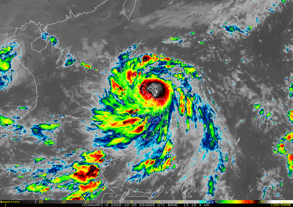
In its latest bulletin, the state weather bureau said Typhoon Quinta (international name Molave), was last spotted at 70 km east northeast of Legazpi City in Albay, as it moves generally westward at 25 kph.
It now has the maximum sustained winds of 130 kph near the center and gustiness of up to 160 kph.
Quinta is seen to make landfall over the eastern coast of Camarines Sur to northeastern coast of Albay between 6 to 8 p.m. tonight. The agency said it is also likely to exit the Philippine Area of Responsibility by Tuesday afternoon.
The following areas have been placed under Signal No. 3, 2 and 1:
Signal No. 3 (121-170 kph winds prevailing or expected in 18 hours)
- Catanduanes
- eastern portion of Camarines Sur (Goa, Ocampo, Bula, Lagonoy, Garchitorena, Caramoan, Presentacion, San Jose, Tigaon, Sagnay, Buhi, Iriga City, Baao, Nabua, Bato, Balatan)
- Albay
- Sorsogon
- Burias and Ticao Islands
The agency said widespread disruption of electrical power and communication services could also be seen in the said areas, along with moderate to heavy damage particularly in the agricultural and industrial sectors.
Signal No. 2 (61-120 kmh winds prevailing or expected in 24 hours)
- Camarines Norte
- rest of Camarines Sur
- Masbate
- central and southern portions of
- Quezon (Mauban, Sampaloc, Lucban, Dolores, Candelaria, Tiaong, San Antonio, Sariaya, Tayabas City, Lucena City, Pagbilao, Atimonan, Perez, Alabat, Calauag, Quezon, Tagkawayan, Guinayangan, Lopez, Pitogo, Plaridel, Gumaca, Unisan, Agdangan, Padre Burgos, Macalelon, Catanauan, General Luna, Buenavista, San Narciso, Mulanay, San Andres, San Francisco)
- southeastern portion of Laguna (Paete, Kalayaan, Lumban, Cavinti, Luisiana, Majayjay, Liliw, Rizal, Nagcarlan, San Pablo City, Alaminos, Magdalena, Pagsanjan)
- Batangas
- Marinduque
- Romblon
- Oriental Mindoro
- Occidental Mindoro including Lubang Island
- Northern Samar
Signal No. 1 (30-60 kmh winds prevailing or expected in 36 hours)
- Metro Manila
- rest of Quezon
- rest of Laguna
- Rizal
- Cavite
- Bulacan
- Pampanga
- Bataan
- southern portion of
- Zambales (San Marcelino, San Felipe, San Narciso, Castillejos, Subic, San Antonio, Olongapo City, Botolan, Cabangan)
- Calamian Islands
- northern portion of Samar (Calbayog City, Matuguinao, Tagapul-An, Santo Nino, Almagro, Santa Margarita, Gandara, San Jose de Buan, Pagsanghan, Tarangnan, San Jorge, Catbalogan City, Jiabong, Motiong, Paranas)
- northern portion of Eastern
- Samar (Maslog, Jipapad, Arteche, San Policarpo, Oras, Dolores, Can-Avid, Taft)
- northern portion of Capiz (SapiAn, Ivisan, Roxas City, Panay, Pilar, Pontevedra, President Roxas)
- Aklan
- northern portion of Antique(Caluya, Libertad, Pandan, Sebaste, Culasi)
- northeastern portion of Iloilo (Batad, Balasan, Estancia, Carles)
Storm surge warning also remains in effect over the coastal areas of Northern Samar, Bicol Region and central and southern portions of Quezon, which could reach between 1 to 2 meters.
The agency said the Bicol Region, CALABARZON, Marinduque, Romblon, Mindoro Provinces and Northern Samar will see a stormy weather condition, with possible flash floods or landslides due to moderate to heavy with occasional intense rains.
Rains with gusty winds, meanwhile, are seen over Metro Manila, Central Luzon, Eastern Samar, Samar, Biliran, Iloilo, Capiz, Aklan, Antique and Calmian Islands still due to Typhoon Quinta.
Disaster officials from Central Visayas, meanwhile, have reported two landslide incidents so far along Calbayog-Catarman Road at Barangay Nabang in Calbayog City, as well as in Maharlika Highway in Barangay Jiaan.
Forecast Positions
- Monday afternoon: 160 km West of Calapan City, Oriental Mindoro
- Tuesday afternoon: 740 km West of Tanauan City, Batangas
- Wednesday afternoon: 1,060 km West of Central Luzon
— Christian Deiparine with reports from Franco Luna


Follow this thread for updates on tropical cyclone Quinta.
Typhoon Quinta is forecast to exit the Philippine Area of Responsibility on Tuesday morning and is seen to intensfy over the West Philippine Sea and reach peak intensity in the next 24 hours, PAGASA says in its early morning bulletin on Tuesday.
The typhoon is expected to bring moderate to heavy rains over Western Visayas, Occidental Mindoro, Palawan including Calamian, Cuyo, and Kalayaan Islands, Aurora, Isabela, Cagayan.
Light to moderate with at times heavy rains over Zamboanga Peninsula, Bangsamoro, Northern Mindanao, Caraga, and the rest of Luzon and Visayas, PAGASA says.
Typhoon Quinta continues to intensify as it moves away from the Philippines, state weather bureau PAGASA says Monday night.
The typhoon is forecast to exit the Philippine Area of Responsibility Tuesday morning and reach its peak intensity within 24 hours.
At 10 p.m., Quinta was located 420 km west of Calapan City, Oriental Mindoro with maximum winds of 140 kph and gusts of 170 kph. It is moving westward at 25 kph.
Signal No. 1 is still hoisted over Lubang Island, Calamian Islands and Kalayaan Islands.
Typhoon Quinta slightly intensifies as it moves towards the western boundary of the West Philippine Sea.
It is forecast to reach its peak intensity in the next 24 hours but would exit the country Wednesday morning, state weather bureau PAGASA says.
At 4 p.m., Quinta was located 310 km west of Calapan City, Oriental Mindoro with maximum sustained winds of 130 kph near the center and gustiness of up to 160 kph.
'Quinta' was 125 kilometers north of Coron, Palawan as of 10 a.m., PAGASA says, or 120 km west southwest of Calapan City, Mindoro.
The typhoon is moving west at 25 km/h and has maximum sustained winds of 125 km/h near the center and gustiness of up to 150 km/h.
Tropical Cyclone Wind Signal No. 3:
Northwestern portion of Occidental Mindoro (Abra de Ilog, Mamburao, Paluan), including Lubang Island
TCWS No. 2 :
Oriental Mindoro
The rest of Occidental Mindoro
Calamian Islands
Batangas
Visayas
Extreme northern portion of Antique (Caluya)
TCWS No. 1:
- Southern portion of Zambales (San Antonio, Castillejos, Subic, Olongapo City)
- Bataan
- Southwestern portion of Pampanga (Floridablanca, Lubao, Sasmuan, Masantol)
- Southwestern portion of Bulacan (Hagonoy, Paombong, Malolos City, Bulacan, Obando, Meycauayan City)
- Metro Manila
- Rizal
- Cavite
- Laguna
- Quezon including Polillo Islands
- Marinduque
- Romblon
- Northern portion of Palawan (El Nido, Taytay), including Cuyo Islands
Visayas
- Aklan and the rest of the northern portion of Antique (Laua-An, Barbaza, Tibiao, Culasi, Sebaste, Pandan, Libertad)
'Quinta' made a fifth landfall over Pola, Oriental Mindoro early Monday morning as it traverses the island and is expected to emerge over the West Philippine Sea.
As of 4 a.m., 'Quinta' was in the vicinity of Socorro, Oriental Mindoro as of 4 a.m., according to an early morning PAGASA bulletin. The typhoon is moving west at 25 kilometers per hour and has maximum sustained winds of 125 km/h near the center and gustiness of up to 180 km/h.
Tropical Cyclone Wind Signal No. 3 is up over the following areas:
- The southern portion of Quezon (Mulanay, San Francisco, Catanauan, General Luna, Macalelon, Pitogo, Unisan, Agdangan, Padre Burgos, Pagbilao, Lucena City, Sariaya, Candelaria, Tiaong, San Antonio, Dolores, Tayabas City)
- Southern portion of Batangas (Lian, Tuy, San Juan, Rosario, Padre Garcia, Lipa City, Cuenca, San Jose, Ibaan, Taysan, Lobo, Batangas City, Mabini, Tingloy, San Pascual, Bauan, Alitagtag, San Luis, Taal, Santa Teresita, Calatagan, Balayan, Calaca, Lemery, Agoncillo, San Nicolas, Mataas Na Kahoy)
- Northern portion of Romblon (Concepcion, Banton, Corcuera, Romblon, San Agustin, Calatrava, San Andres, Odiongan, Santa Maria)
- Marinduque
- Northern and central portion of Oriental Mindoro (Oriental Mindoro (Mansalay, Roxas, Bongabong, Bansud, Gloria, Pinamalayan, Pola, Socorro, Victoria, Naujan, Calapan City, Baco, San Teodoro, Puerto Galera)
- Northern and central portion of Occidental Mindoro (San Jose, Rizal, Calintaan, Sablayan, Santa Cruz, Mamburao, Paluan, Abra de Ilog) including Lubang Island
Tropical Cyclone Wind Signal No. 2 areas:
- Camarines Norte
- Western portion of Camarines Sur (Siruma, Tinambac, Calabanga, Naga City, Pili, Bula, Balatan, Minalabac, Milaor, Bombon, Magarao, Canaman, Camaligan, Gainza, San Fernando, Pasacao, Pamplona, Cabusao, Libmanan, Sipocot, Lupi, Ragay, Del Gallego)
- Burias Island
- Rest of Quezon, including Polillo Islands
- Laguna
- Rest of Batangas
- Cavite, Rizal
- Metro Manila
- Southern portion of Bulacan (Norzagaray, Angat, San Rafael, Baliuag, Pulilan, Calumpit, Hagonoy, Paombong, Malolos City, Plaridel, Bustos, San Jose del Monte City, Santa Maria, Pandi, Guiguinto, Balagtas, Bulacan, Bocaue, Meycauayan City, Obando, Marilao)
- Southern portion of Pampanga (Lubao, Sasmuan, Macabebe, Masantol, Minalin, Apalit), Bataan
- Rest of Romblon
- Rest of Oriental Mindoro
- Rest of Occidental Mindoro, and Calamian Islands
Visayas
- Extreme northern portion of Antique (Caluya)
Tropical Cyclone Wind Signal No. 1 areas:
- Catanduanes
- Rest of Camarines Sur
- Albay
- Western portion of Sorsogon (Donsol, Pilar, Castilla, Sorsogon City, Casiguran, Juban, Magallanes, Bulan, Irosin)
- Northern portion of mainland Masbate (Uson, Mobo, Masbate City, Baleno, Aroroy, Balud, Mandaon, Milagros) including Ticao Island
- Southern portion of Aurora (Dingalan, San Luis)
- Southern portion of Nueva Ecija (Gabaldon, Laur, Palayan City, General Tinio, Cabanatuan City, Aliaga, Zaragoza, Jaen, San Antonio, Santa Rosa, Peñaranda, Gapan City, San Leonardo, San Isidro, Cabiao)
- Southern portion of Tarlac (La Paz, Tarlac City, San Jose, Concepcion, Capas, Bamban)
- Rest of Bulacan
- Rest of Pampanga
- Central and southern portion of Zambales (Iba, Botolan, Cabangan, San Felipe, San Narciso, San Antonio, San Marcelino, Castillejos, Subic, Olongapo City)
- Northern portion of Palawan (El Nido, Taytay) including Cuyo Islands
Visayas
- The rest of the northern portion of Antique (Laua-An, Barbaza, Tibiao, Culasi, Sebaste, Pandan, Libertad)
- Aklan
- Capiz
- Northern portion of Iloilo (Lemery, Sara, San Dionisio, Batad, Estancia, Carles, Balasan)


- Latest
- Trending