Threat posed by ‘Tisoy’ increases as powerful typhoon nears landfall
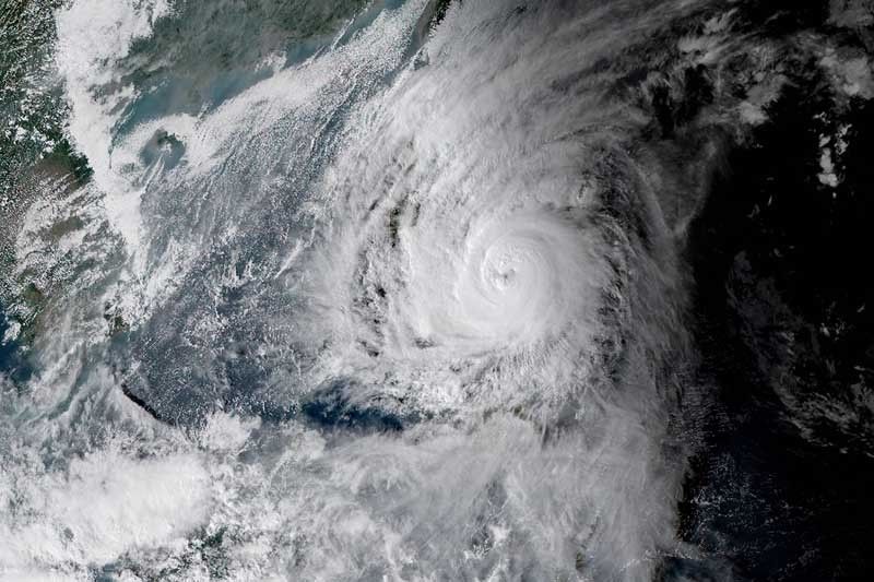
MANILA, Philippines — The threat to the Philippine landmass from Typhoon Tisoy (Kammuri) has grown as it moves closer to Bicol region and Eastern Visayas area, state weather bureau PAGASA said.
“Tisoy” has already forced suspensions of class and work and the cancellation of some events in the 30th Southeast Asian Games even before making a landfall.
The typhoon is forecast to crash into land in Catanduanes, Albay or Sorsogon between Monday evening and early Tuesday morning, PAGASA said.
It was last spotted 195 kilometers east of Juban, Sorsogon maintaining its peak winds of 150 kph and gusts of up to 185 kph. “Tisoy” is heading west at 20 kph.
The state weather bureau has placed more areas in under Tropical Cyclone Wind Signals as “Tisoy” moves closer to land.
TCWS No. 3 has been raised over parts of Bicol region and Eastern Visayas. Residents of these areas should brace for winds between 121 kph and 170 kph in 18 hours.
- Catanduanes
- Camarines Sur
- Albay
- Sorsogon
- Southern portion of Camarines Norte (Daet, San Vicente, San Lorenzo Ruiz, Basud, Mercedes)
- Masbate including Ticao and Burias Islands
- Romblon
- Southern portion of Quezon (Mulanay, San Narciso, San Francisco, San Andres)
- Northern Samar
- Northern portion of Eastern Samar (Can-avid, Dolores, Maslog, oras, Arteche, Jipapad, San Policarpio)
- Northern portion of Samar (Catbalogan, Jiabong, Motiong, Paranas, San Jose de Buan, San Jorge, Pagsanghan, Tarangnan, Sta. Margarita, Gadara, Matuguinao, Calbayog, Tagapul-an, Almagro, Sto. Niño
Meanwhile, winds between 61 kph and 120 kph may prevail or be experienced in the following areas under TCWS No. 2 in 24 hours:
- Metro Manila
- Bulacan
- Bataan
- Tarlac
- Pampanga
- Nueva Ecija
- Southern Aurora (Dipaculao, Maria Aurora, Baler, San Luis, Dingalan)
- Cavite
- Batangas
- Laguna
- Rizal
- Rest of Quezon including Polillo Islands
- Oriental Mindoro
- Occidental Mindoro
- Marinduque
- Rest of Camarines Norte
- Calamian Islands
- Southern portion of Zambales (San Marcelino, San Antonio, Castillejos, Subic, Olongapo)
- Rest of Eastern Samar
- Rest of Samar
- Biliran
- Aklan
- Capiz
- Northern portion of Antique (Valderrama, Bugasong, Laua-an, Barbaza, Tibiao, Culasi, Sebaste, Pandan Libertad)
- Northern portion of Iloilo (Janiuay, Badiangan, Pototan, Barotac Nuevo, Anilao, Dingle, Dueñas, Lambunao, Calinog, Passi, San Enrique, Banate, Barotac Viejo, San Rafael, Bingawan, Lemery, Ajuy, Sara, Concepcion, San Dionisio, Batad, Estancia, Balasan, Carles
- Northern portion of Negros Occidental (Talisay, Calatrava, Silay, Enrique B. Magalona, Victorias, Manapla, Cadiz, Sagay, Escalante, Toboso)
- Northern Cebu (Daanbantayan, Batnayan, Madridejos, Santa Fe, Medellin, Bogo City, San Remigio, Tabogon, Tabuelan, Tuburan, Carmen Borbon, Sogod, Catmon, Asturias, and Camotes Islands)
- Northern portion of Leyte (Baybay, Mahaplag, Abuyog, Javier, Macarthur, Mayorga, La Paz, Dulag, Albuera, Barauen, Julita, Tolosa, Tanauan, Tabontabon, Dagami, Pastrana, Palo, Sta. Fem Tacloban, Alangalang, Jaro, Babatngon, San Miguel, Barugo, Tunga, Carigara, Capoocan, Leyte, Calubian, San Isidro, Tabango, Villaba, Kananga, Matag-ob, Palompon, Isabel, Merida, Ormoc)
These areas under TCWS No. 1 will experience winds between 30 to 60 kph in at least 36 hours:
- Southern Isabela (Palanan, Dinapigue, San Mariano, San Guillermo, Benito Soliven, Naguilian, Reina Mercedes, Luna, Aurora, Cabatuan, San Mateo, Cauayan City, Alciia, Angadanan, Ramon, San Isidro, Echague, Cordon, Santiago City, Jones and San Agustin)
- Mountain Province
- Ifugao
- Benguet
- Nueva Vizcaya
- Ilocos Sur
- La Union
- Pangasinan
- Quirino
- Rest of Aurora
- Rest of Zambales
- Rest of Antique
- Rest of Iloilo
- Guimaras
- Rest of Negros Occidental
- Metro Cebu (Balamban, Toledo City, Pinamungahan, Aloguinsan, Naga Citu, Talisay City, Cordova, Minglanilla, Lapu-Lapu City, Mandaue City, Cebu City, Consolacion, Liloan, Compostela and Danao City)
- Rest of Leyte
- Southern Leyte
- Dinagat Islands
- Siargao Island
‘Tisoy’ to dump heavy to intense rains
Residents of Bicol region, Samar provinces and Biliran will experience heavy rains until Monday afternoon as the outer bands of “Tisoy” is already affecting Bicol and Eastern Visayas.
Meanwhile, those living in northern Cebu, northern Negros Island, Dinagat Islands, Siargao Island and the rest of Eastern Visayas will have intermittent heavy rains until afternoon.
After landfall over Bicol area, the typhoon is forecast to cross southern Luzon on Tuesday.
Between Monday afternoon and Tuesday noon, there will be frequent to continuous heavy to intense rains over Bicol region, northern Samar, southern Quezon and Marinduque and occasional heavy rains over Romblon, Mindoro provinces, Samar, Eastern Samar and the rest of Calabarzon.
“Tisoy” will also bring intermittent heavy rains over Metro Manila, Central Luzon, eastern portions of Cagayan and Isabela and the rest of Eastern Visayas between Monday afternoon and Tuesday noon.
Between Tuesday noon and Wednesday noon, frequent to continuous heavy to intense rains are forecast to hit Central Luzon, Metro Manila, CALABARZON, Bicol region, Mindoro provinces, Marinduque and Romblon.
Meanwhile, residents of Cordillera Administrative Region, Cagayan Valley, Panagasinan, Aklan, Capiz and northern Antique will experience intermittent to occasional heavy rains.
Possible storm surge
PAGASA also said there could be storm surge with height of more than 3 meters in:
- Mercedes and Mandao in Camarines Norte
- Cabusao, Bombon, Calabanga, Tinambac and Sipocot in Catanduanes
Storm surge with height of 1 to 3 meters is also possible over several coastal areas in Quezon, Camarines Norte, Camarines Sur, Catanduanes and Samar.
Storm surge is the abnormal rise in sea level caused by strong winds and low atmospheric pressures produced by tropical cyclones.
Sea travel, especially for small seacrafts, is dangerous over:
- Seaboards of areas under TCWS
- Seaboards of northern Luzon
- Western seaboard of Palawan
- Central seaboards of Visayas
- Northern and eastern seaboards of Mindanao
Forecast positions
- Tuesday morning: In the vicinity of Torrijos, Marinduque
- Wednesday morning: 290 km west of Subic, Zambales
- Thursday morning: 605 km west of Subic, Zambales (outside PAR)
- Friday morning: 795 km west of Coron, Palawan (outside PAR)


- Latest
- Trending