Signal No. 1 up in Davao Oriental where 'Chedeng' is seen to make landfall
MANILA, Philippines — Signal No. 1 has been raised over Davao Oriental hours after Tropical Depression Chedeng entered the Philippine area of responsibility, state weather bureau PAGASA said.
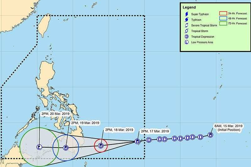
At 4 p.m., PAGASA said “Chedeng” was estimated based on all available data at 830 km east of Hinatuan, Surigao del Sur. It packs maximum sustained winds of 45 kilometers per hour near the center and gustiness of up to 60 kph.
The third tropical cyclone of 2019 was seen moving west at 25 kph.
PAGASA earlier said “Chedeng” may make landfall over the eastern coast of Davao Oriental between Monday evening and Tuesday morning.
It, however, said there is a possibility that the tropical depression may weaken into a low pressure area before coming onshore.
The state weather bureau said scattered to at times widespread moderate to heavy rains are expected over the areas of Davao Oriental and Surigao del Sur on Monday and in other parts of Mindanao on Tuesday.
Signal No. 1 may also be raised over Davao del Norte and Compostela Valley in PAGASA’s next update.
Residents in these areas especially those living in low-lying areas are advised to take necessary preparations and continue to monitor updates for possible flooding and landslides.
Disaster risk reduction and management offices concerned are also asked to be alert for these possibilities.
Meanwhile, small seacrafts are advised to avoid venturing out to sea as moderate to rough seas may persist over the eastern seaboard of Visayas and Mindanao on Monday and Tuesday. — Rosette Adel
The tropical depression PAGASA is monitoring continues to move generally westward near Palau and is expected to enter the Philippine area of responsibility this early afternoon. It will be assigned the name "Chedeng."
As of 10 a.m., the center of the tropical depression was estimated based on all available data at 980 km east of Mindanao It packs maximum sustained winds of 45 kph near the center and gustiness of up to 60 kph.
Small sea vessels that ply the route between the Sta. Ana Wharf in Davao City and the Island Garden City of Samal have been grounded by the Philippine Coast Guard.
The Davao region is under Tropical Cyclone Warning Signal No. 1 due to 'Chedeng'.
PAGASA raises Signal No. 1 over Davao Oriental as Tropical Depression Chedeng may make landfall over the eastern coast of the province between tomorrow evening and Tuesday morning.
It adds that Signal No. 1 may be raised over Davao del Norte and Compostela Valley in the next bulletin.
At 4 p.m. today, the center of "Chedeng" was estimated based on all available data at 830 km east of Hinatuan, Surigao del Sur.
It packs maximum sustained winds of 45 kph near the center and gustiness of up to 60 kph.
PAGASA says the center of Tropical Depression Chedeng has entered PAR at 11 a.m. today and was estimated to be located at 950 km east of Hinatuan, Surigao del Sur.
At 11:00 AM today, the center of Tropical Depression "CHEDENG" has entered the Philippine Area of Responsibility and was estimated at 950 km East of Hinatuan, Surigao del Sur. Severe Weather Bulletin #1 will be issued at 5:00 PM today.
— PAGASA-DOST (@dost_pagasa) March 17, 2019


- Latest
- Trending