Urduja to bring rains over Bicol, Visayas
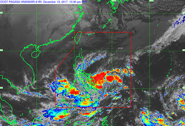
As of 10 p.m. Wednesday night, the center of Urduja was spotted at 295 kilometers east of Guiuan, Eastern Samar, packing winds of 55 kilometers per hour and gustiness of up to 65 kph. PAGASA/Released
MANILA, Philippines — The state weather bureau warned residents of the Bicol region and Eastern Visayas to brace for possible flashfloods and landslides as Tropical Depression Urduja maintained its strength and continued to approach Samar Island.
As of 10 p.m. Wednesday night, the center of Urduja was spotted at 295 kilometers east of Guiuan, Eastern Samar, packing winds of 55 kilometers per hour and gustiness of up to 65 kph.
The Philippine Atmospheric, Geophysical and Astronomical Services Administration (PAGASA) said the weather disturbance was forecast to move west northwest at seven kph.
Tropical Cyclone Warning Signal No. 1 was raised over Eastern Samar, Northern Samar and Samar.
Winds of 30 to 60 kph are expected in these areas in the next 36 hours.
Urduja is expected to bring scattered to widespread moderate to heavy rains in areas within the 400 km diameter of the tropical depression.
PAGASA weather division chief Esperanza Cayanan said signal No. 1 was also expected to be raised over Sorsogon, Masbate and the rest of Samar Wednesday night or early Thursday.
Scattered to widespread rains meanwhile are expected over MIMAROPA, Bicol Region, Visayas and Mindanao, and the residents of these areas are alerted against possible flashfloods and landslides.
Cayanan advised fishermen against going out into the eastern seaboard of Bicol region and Eastern Visayas due to moderate to rough seas associated with the approaching cyclone.
Urduja is expected to move closer to Philippine landmass Friday evening or Saturday morning. The cyclone is expected to be 175 km east of Borongan City, Eastern Samar Thursday evening and 145 km east southeast of Catarman, Northern Samar on Friday evening.
Cayanan said while Metro Manila is far from the center of Urduja, the cyclone’s outer spiral rainband could still reach the capital.
“When we look at the cone of uncertainty, Metro Manila is covered by the cyclone’s circulation, which means it could also experience rains from Urduja,” Cayanan said.
The northeast monsoon is also expected to bring light to moderate rains and slightly cooler temperature over Metro Manila in the next days.
In anticipation of heavy rains, the National Disaster Risk Reduction and Management Council (NDRRMC) yesterday raised its disaster alert status to blue. – Jaime Laude


- Latest
- Trending