


What went wrong: Paeng's high death toll
MANILA, Philippines (Update 2, 5:28 p.m.) — Severe Tropical Storm Paeng (international name: Nalgae) is one of the most destructive tropical cyclones that pounded the Philippines this year.
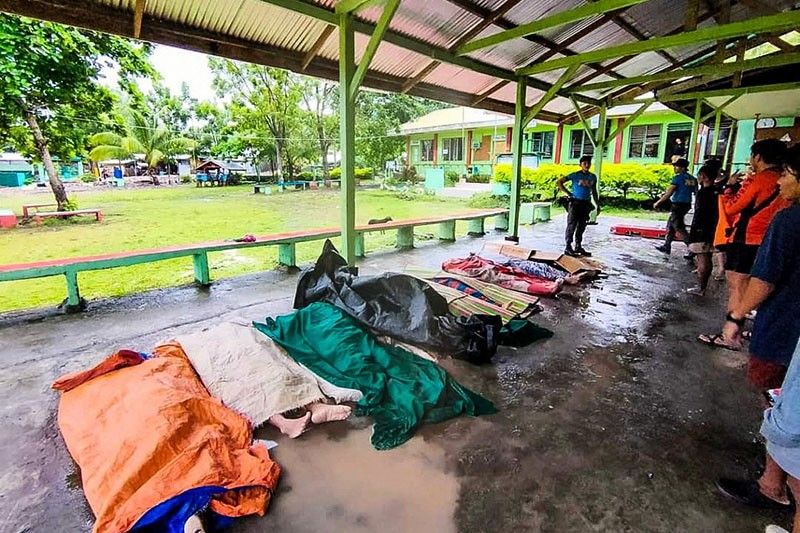
As of Friday morning, officials report that at least 154 people died in floods and landslides triggered by Paeng. The devastation from Paeng shocked the country, including President Ferdinand Marcos Jr. who questioned the tally and said it was "a little too high."
Prior to landfall, the government had issued warnings of heavy rainfall and potential flooding in parts of Mindanao, science and technology chief Renato Solidum Jr. said. The Bangsamoro Autonomous Region in Muslim Mindanao — where many died due to floods and landslides — had issued similar warnings.
BARMM, which is rarely in the path of typhoons but often experiences flash floods when the Liguasan Marsh overflows, recorded 63 deaths. For a country no stranger to tropical storms, the question, then, is why was Paeng so deadly?
READ: 20 Maguindanao del Norte landslide fatalities buried
Caught off guard
One of the hardest-hit areas is the village of Kusiong in Datu Odin Sinsuat, Maguindanao del Norte. The relocation site, home to the Teduray and Maguindanaoan peoples, was buried in mud, rocks and boulders.
“The major cause of deaths was a mix of flooding and landslides which was not anticipated,” BARMM interior and local government minister Naguib Sinarimbo said in a briefing Tuesday.
Authorities in the autonomous region did not expect that Paeng’s rains would trigger landslides as the Bangsamoro was not in the direct path of the cyclone.
"The usual flooding in this region occurs in the communities surrounding the Liguasan Marsh. The perennial flooding in this area has not caused deaths in the October 28 incident," Sinarimbo said, noting most fatalities were reported in mountainous municipalities.
According to the government’s geohazard assessment, Kusiong is a hazard-prone area that is susceptible to landslides and flooding.
Disaster managers in the country are often focused on bracing for the impacts of a cyclone’s landfall, said Timothy James Cipriano, a geographer who studies hazards and disasters.
RELATED: State of calamity declared in Calabarzon, Bicol, Western Visayas, BARMM
"‘Yung circulation niya, ‘yung eyewall, outer rainbands nasa loob na ng Philippine Area of Responsibility ‘yun. It brings rain. ‘Yun siguro ‘yung kailangang focus ng disaster managers rather than looking at the definition of landfall," Cipriano told Philstar.com.
(Paeng's circulation, its eyewall, outer rainbands were already inside the Philippine Area of Responsibility. It brings rains. Maybe that should be the focus of disaster managers rather than looking at the definition of landfall.)
Paeng last week made landfalls in Virac in Catanduanes, Caramoan in Camarines Sur, Buenavista in Quezon province, Santa Cruz in Marinduque, and Sariaya in Quezon province —all in Luzon.
Cipriano stressed the need for risk assessments at barangay and municipal levels. The Philippine Daily Inquirer reported that some of the families in Kusiong were relocated there from coastal areas in Datu Odin Sinsuat following the 1976 Moro Gulf earthquake and a resulting tsunami that killed at least 5,000 people.
Cipriano added that probabilistic risk assessment, which simulates future disasters that are likely to occur and their worst case scenarios, should be done. Better coordination and communication among local disaster offices, NDRRMC, and PAGASA are also needed.
Tree planting
Marcos blamed deforestation for the deadly landslides in BARRM as he urged authorities to plant trees on denuded mountains.
"We’ve been hearing this over and over again pero patuloy pa rin tayong nagpuputol ng kahoy. Kaya anong nangyayari? Nagkaka-landslide ng ganyan," Marcos said.
(We've been hearing this over and over again but tree cutting continues? That's why landslides like those happen.)
In an email to Philstar.com, Bangsamoro’s Ministry of Environment, Natural Resources and Energy (MENRE) said that deforestation in the area was "primarily caused [by] timber licensing agreements awarded and other timber industries operating in Mindanao decades ago." Kaingin or slash-and-burn and the conversion of forestland into farmlands are also drivers of forest loss in the area.
Deforestation worsened during the Ferdinand Marcos Sr. dictatorship as the Philippines became a major exporter of logs. Timber licensing agreements were given to the relatives and cronies of Marcos Sr.
To prevent a repeat of last week’s devastation, MENRE said it would reinforce the implementation of the Integrated Bangsamoro Greening Program that started in 2019 and push for the re-entry of the national government’s green program in the region.
The ministry also plans to establish a green corridor, enrich the existing vegetation in the area, and employ combined vegetative and structural interventions in hazard-prone areas.
"The MENRE also recommends to the [government of] Barangay Kusiong to set up landslide warning signages within the location and initiate readiness and measures for the identified geohazards because an increase in rainfall will further lead to natural damming, slumping and occurrences of landslide and flash floods," it said.
NDRRMC, for its part, will review the land use plans of local government units, its spokesperson Raffy Alejandro told Philstar.com.
"We have to check if we’re really building communities in safe areas," he said.
SPECIAL REPORT: Strong enforcement, halt to destruction needed to reverse decades of neglect of Upper Marikina watershed
Climate change adaptation
The Philippines, which already sees an average of 20 cyclones each year, is among the countries most vulnerable to extreme weather caused by climate change and is among the countries that do not have enough resources for adaptation and mitigation initiatives.
According to an Intergovernmental Panel on Climate Change report released in 2021, the frequency and intensity of heavy precipitation events have increased since the 1950s due to climate change.
The World Risk Index 2022 ranked the Philippines first on the list of global disaster hotspots. The report, which measured a country’s exposure and vulnerability to hazards, assessed 193 countries.
"We have to take into account climate change and disaster risk reduction in our development plans because we cannot separate development, DRR, and climate change adaptation because they are always connected," Cipriano said.
"If we don’t invest on these, then we would always end up rebuilding after every disaster," he added.


- Latest


