


'Paeng' intensifies slightly as it nears land
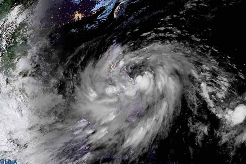
MANILA, Philippines — Tropical Storm Paeng (Nalgae) has intensified slightly while heading to the areas of northern Samar, Sorsogon and Albay, state weather bureau PAGASA said Friday.
The cyclone was last seen 180 kilometers east of Catarman in Northern Samar with peak winds of 85 kph near the center and gusts of up to 105 kph. Moving west northwest at 25 kph, it is forecast to make a landfall or pass close to Northern Samar Friday night.
Paeng, the country’s 16th tropical cyclone this year and the fourth in October, is expected to bring heavy rains and strong winds as millions of Filipinos prepare to visit their departed loved ones on All Saints Day and All Souls Day.
FOLLOW: LIVE updates: Tropical storm Paeng
Weather forecasters raised wind signals over the following areas:
TCWS No. 2 (Winds between 62 kph and 88 kph expected in at least 24 hours)
- Catanduanes
- Albay
- Sorsogon
- Masbate including Ticao Island and Burias Islands
- Camarines Sur
- Camarines Norte
- Marinduque
- Quezon including Pollilo Islands
- Southern portion of Aurora (San Luis, Baler, Dingalan)
- Southeastern portion of Nueva Ecija (Gabaldon, General Tinio, City of Gapan, Cabiao, San Isidro, Pe)
- Laguna
- Batangas
- Cavite
- Metro Manila
- Rizal
- Bulacan
- Eastern portion of Pampanga (Candaba, San Luis, San Simon, Apalit)
- Northern and central portions of Oriental Mindoro (Puerto Galera, San Teodoro, Baco, City of Calapan, Naujan, Victoria, Pola, Socorro, Pinamalayan, Gloria, Bansud, Bongabong, Roxas)
- Romblon
- Northern Samar
- Eastern Samar
- Samar
- Biliran
- Northern portion of Leyte (San Isidro, Calubian, Tabango, Leyte, Capoocan, Carigara, Barugo, San Miguel, Babatngon, Tacloban City, Alangalang, Santa Fe, Palo, Tanauan, Dagami, Pastrana, Jaro, Kananga, Villaba, Tunga, Tabontabon, Tolosa)
TCWS No. 1 (Winds between 39 kph and 61 kph expected in at least 36 hours or intermittent rains within 36 hours)
- Nueva Vizcaya
- Quirino
- Central and southern portions of Isabela (San Agustin, Jones, City of Santiago, Cordon, Echague, Dinapigue, San Mariano, San Guillermo, Angadanan, City of Cauayan, Benito Soliven, Ramon, San Isidro, Alicia, San Mateo, Cabatuan, Luna, Reina Mercedes, Naguilian, Palanan, Aurora, Burgos, San Manuel, Gamu, Ilagan City, Divilacan, Roxas, Quirino, Mallig)
- Ifugao
- Benguet
- Mountain Province
- Southern portion of Ilocos Sur (Sugpon, Cervantes, Alilem, Suyo, Tagudin, Santa Cruz, Sigay, Quirino, Gregorio del Pilar, Salcedo, Santa Lucia)
- La Union
- Bataan
- Tarlac
- Zambales
- Pangasinan,
- Rest of Aurora
- Rest of Pampanga
- Occidental Mindoro including Lubang Islands
- Rest of Oriental Mindoro, Calamian Islands, Cuyo Islands
- Rest of Nueva Ecija
- Southern Leyte
- Cebu including Bantayan and Camotes Islands
- Bohol
- Negros Occidental
- Negros Oriental
- Guimaras
- Aklan
- Antique
- Capiz
- Iloilo
- Siquijor
- Rest of Leyte
- Dinagat Islands
- Surigao del Norte including Siargao and Bucas Grande Islands
- Northern portion of Surigao del Sur (Carrascal, Cantilan, Madrid, Carmen, Lanuza, Cortes, City of Tandag, Bayabas, Cagwait, San Miguel, Tago, Marihatag)
- Agusan del Norte
- Northeastern portion of Agusan del Sur (Sibagat)
- Camiguin
- Eastern portion of Misamis Oriental (Gingoog City, Magsaysay, Medina, Talisayan, Balingoan, Kinoguitan)
What to expect
According to PAGASA, winds may reach gale-force strength during the passage of Paeng in any of the areas where TCWS No. 2 is hoisted. Strong winds may be experienced in any of the areas where TCWS No. 1 is raised.
“Per latest track and intensity forecast, the highest wind signal that will likely be hoisted is Wind Signal No. 3 in anticipation of storm-force conditions associated with Paeng,” the agency said.
The surge of the enhanced northeast monsoon will also bring strong winds with gusts reaching gale-force strength over Batanes, Babuyan Islands, Ilocos Norte, the northern and eastern portions of mainland Cagayan, and the northern portion of Apayao.
Weather forecasters said the tropical storm will dump heavy to intense with at times torrential rains to Bicol region and Eastern Visayas until early Saturday morning.
Meanwhile, heavy with at times intense rains are expected over Quezon, MIMAROPA, Caraga, Zamboanga Peninsula, Bangsamoro Autonomous Region in Muslim Mindanao, Northern Mindanao and the rest of Visayas.
Residents of Metro Manila, Bulacan, Pampanga, Cagayan Valley, Aurora, the rest of Calabarzon, and the rest of Mindanao will experience light to moderate with at times heavy rains.
PAGASA warned there is “minimal to moderate risk” of storm surge of up to 2 meters which may cause flooding in the low-lying and exposed coastal areas of the Bicol region, Quezon province including Polillo Islands, eastern portion of Aurora, northern and eastern portions of Northern Samar, and eastern portion of Eastern Samar.
Paeng is expected to make a landfall or pass close to Northern Samar tonight. Then, it will traverse the Bicol region late Friday until Saturday morning.
According to PAGASA, the cyclone may make another landfall over the east coast of Quezon, including Polillo Islands.
Paeng is forecast to intensify further while moving over the warm waters of the Philippine Sea and may reach severe tropical storm category within 12 hours.
Paeng’s track
- Oct 29, 2022 02:00 a.m. - Over the coastal waters of Rapu-Rapu, Albay
- Oct 29, 2022 02:00 p.m. - In the vicinity of Calauag, Quezon
- Oct 30, 2022 02:00 a.m. - In the vicinity of Poroc, Pampanga
- Oct 30, 2022 02:00 p.m. - 90 km west Northwest of Iba, Zambales or 130 km West Southwest of Dagupan City, Pangasinan
- Oct 31, 2022 02:00 a.m. - 215 km west of Baguio City, Benguet
- Oct 31, 2022 02:00 p.m. - 230 km west of Sinait, Ilocos Sur
- Nov 01, 2022 02:00 p.m. - 290 km west of Calayan, Cagayan
- Nov 02, 2022 02:00 p.m. - 180 km west of Itbayat, Batanes


- Latest
- Trending


