


Super typhoon Rolly makes second landfall in Albay
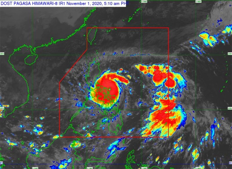
MANILA, Philippines (Update 2 9:15 a.m.) — "After intensifying into a super typhoon "Rolly" made its second landfall over Tiwi, Albay, state bureau PAGASA said.
In its 8 a.m. severe weather bulletin, PAGASA said that "Rolly" made landfall at 7:20 a.m. as it continues to traverse the Luzon landmass.
The super typhoon is bearing peak winds of 225 kilometers per hour near the center and gusts of up to 310 kph. It is moving west southwest at 25 kph.
Rolly made its first landfall over Bato, Catanduanes at around 4:50 a.m. on Sunday.
"Catastrophic violent winds and intense to torrential rainfall associated with the region of the eyewall and inner rainbands of the typhoon is prevailing or expected within the next 12 hours over Catanduanes, Camarines Norte, Camarines Sur, Albay, the northern portion of Sorsogon, Burias Island, Marinduque, the central and southern portions of Quezon, Laguna, and the eastern portion of Batangas," PAGASA said.
"This a particularly dangerous situation for these areas," it added.
Signal No. 5 has been hoisted in several parts in Bicol Region. The following areas have been placed under storm warning signals.
Signal No. 5
(More than 220 km/h winds prevailing or expected in 12 hours)
- Albay
- Camarines Sur
Signal No. 4
(171-220 km/h winds prevailing or expected in 12 hours)
- Catanduanes
- Camarines Norte
- the northern portion of Sorsogon (Donsol, Pilar, Castilla, Sorsogon City, Prieto Diaz, Gubat, Barcelona, Juban, Casiguran, Magallanes)
- Burias Island
- the central and southern portions of Quezon (Real, Mauban, Perez, Alabat, Quezon, Calauag, Tagkawayan, Guinayangan, San Antonio, Tiaong, Dolores, Candelaria, Sariaya, Tayabas City, Sampaloc, Lucban, Lucena City, Pagbilao, Atimonan, Padre Burgos, Agdangan, Unisan, Plaridel, Gumaca, Lopez, Buenavista, San Narciso, San Andres, San Francisco, Mulanay, Catanauan, General Luna, Macalelon, Pitogo)
- the central and southern portions of Rizal (Tanay, Antipolo City, San Mateo, Cainta, Taytay, Binangonan, Teresa, Morong, Cardona, Baras, Jala-Jala, Pililla, Angono)
- Batangas
- Cavite
- Metro Manila
- Laguna
- Marinduque
- the northern portion of Romblon (Concepcion, Corcuera, Banton)
- the northern portion of Occidental Mindoro (Abra de Ilog)
- the northern portion of Oriental Mindoro (Puerto Galera, San Teodoro, Baco, Calapan City, Naujan, Pola, Victoria, Socorro, Pinamalayan)
Signal No. 3
(121-170 km/h winds prevailing or expected in 18 hours)
- The rest of Sorsogon
- the northern portion of Masbate (Mobo, Masbate City, Milagros, Uson, Baleno, Aroroy, Mandaon) including Ticao Island
- the rest of Quezon including Polillo Island
- the rest of Rizal
- Bulacan
- Pampanga
- Bataan
- the southern portion of Zambales (San Marcelino, San Felipe, Olongapo City, Subic, Castillejos, San Antonio, San Narciso, Botolan, Cabangan)
- the central portion of Romblon (Calatrava, San Andres, San Agustin, Romblon, Magdiwang, San Fernando, Cajidiocan)
- the central portion of Occidental Mindoro (Sablayan, Mamburao, Santa Cruz, Paluan) including Lubang Island
- the central portion of Oriental Mindoro (Gloria, Bansud, Bongabong) Northern Samar
Signal No. 2
(61-120 km/h winds prevailing or expected in 24 hours)
- Aurora
- Nueva Vizcaya
- Quirino
- Benguet
- La Union
- Pangasinan
- the rest of Zambales
- Tarlac
- Nueva Ecija
- the rest of Oriental Mindoro
- the rest of Occidental Mindoro
- the rest of Romblon
- the rest of Masbate
- The northern portion of Samar (Catbalogan City, Jiabong, Motiong, Paranas, Hinabangan, San Sebastian, Tarangnan, Pagsanghan, San Jorge, San Jose de Buan, Matuguinao, Gandara, Santa Margarita, Calbayog City, Santo Nino, Almagro, Tagapul-An)
- the northern portion of Eastern Samar (San Julian, Sulat, Taft, Can-Avid, Dolores, Maslog, Oras, San Policarpo, Arteche, Jipapad)
- the extreme northern portion of Antique (Pandan, Libertad, Caluya)
- the northwestern portion of Aklan (Buruanga, Malay, Nabas, Ibajay)
Signal No. 1
(30-60 km/h winds prevailing or expected in 36 hours)
- Mainland Cagayan
- Isabela
- Apayao
- Kalinga
- Mountain Province
- Ifugao
- Abra
- Ilocos Norte
- Ilocos Sur
- Calamian Islands
- The rest of the northern portion of Antique (Sebaste, Culasi, Tibiao, Barbaza, Laua-An)
- the rest of Aklan
- Capiz
- the northern portion of Iloilo (Lemery, Sara, Concepcion, San Dionisio, Batad, Estancia, Balasan, Carles)
- the northern portion of Cebu (San Remigio, Bogo City, Medellin, Daanbantayan) including Bantayan Islands
- Biliran
- the rest of Samar
- the rest of Eastern Samar
- the northern portion of Leyte (San Isidro, Tabango, Villaba, Matag-Ob, Palompon, Ormoc City, Pastrana, Palo, Calubian, Leyte, Kananga, Capoocan, Carigara, Jaro, Tunga, Barugo, Alangalang, Santa Fe, Tacloban City, Babatngon, San Miguel)
Storm surge
Storm surge warning remains in the next 24 hours over the following areas:
- coastal areas of Catanduanes and Camarines Norte and the northern coastal areas of Quezon including Polillo Islands and Camarines Sur
- coastal areas of Metro Manila, Cavite, Bulacan, Pampanga, Bataan
- the southeastern coastal area of Batangas (facing Tayabas Bay)
- most of the southern coastal areas of Quezont
- he coastal areas of Marinduque, Lubang Island, Albay, Masbate (including Ticao and Burias Islands), Northern Samar, and Eastern Samar
- the remaining coastal areas of Quezon, Camarines Sur, and Batangas
- the coastal areas surrounding Laguna de Bay and Taal Lake
Rains, flood, landslides, lahar
“Rolly” will bring bring heavy to intense with at times torrential rains over Bicol Region, Calabarzon, Metro Manila, Marinduque, Romblon, Mindoro Provinces, Bataan, Bulacan, Aurora, Northern Samar, Samar, Eastern Samar, Biliran, and the eastern portions of mainland Cagayan and Isabela.
Moderate to heavy rains with at times intense rains will pummel Cordillera Administrative Region, Leyte, and the rest of mainland Cagayan Valley and Central Luzon.
Meanwhile, light to moderate with at times heavy rains will be experienced over Caraga, Northern Mindanao, Zamboanga Peninsula, and the rest of Luzon and Visayas.
PAGASA is warning of flooding, rain-induced landslides, lahar flows due to prolonged rainfall.
"Rolly" is expected to exit the mainland Luzon landmass and emerge over the Philippine Sea Monday early morning,.
PAGASA also warned about a tropical cyclone outside the Philippine Area of Responsibility. "Atsani" has reintensified from a tropical depression into a tropical storm at 2 a.m. Sunday. Its eye was last seen at 1,280 km east of southern Luzon.
"Atsani" has maximum sustained winds of 65 kph near the center and gustiness of up to 80 kph. It is moving west-northwestward at 30 kph and is expected to enter PAR on Sunday afternoon. It will be given the local name "Siony" once it enters PAR. .
Forecast position
-
24 hours (Monday morning):150 km west of Subic Bay
-
48 hours (Tuesday morning): 625 km west of Subic Bay (Outside PAR)
-
72 hours (Wednesday morning): 970 km west of Central Luzon (Outside PAR)


- Latest
- Trending


