


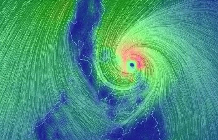
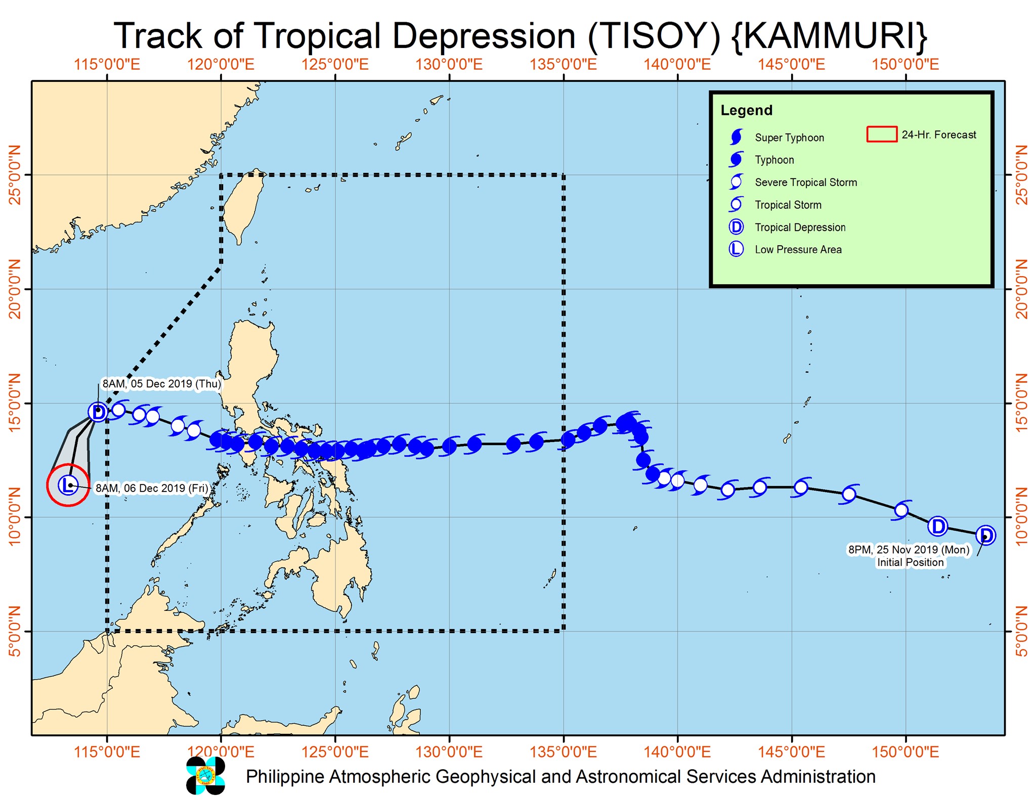
Tropical Cyclone Tisoy
The number of people killed by Typhoon Tisoy (Kammuri)'s pounding of the Philippines this week has hit 13, officials say Thursday, as authorities confirmed reports of storm-related deaths.
Kammuri's fierce winds toppled trees and flattened flimsy homes across a swathe of the nation's north on Tuesday, and forced a rare 12-hour shutdown of Manila's international airport.
Authorities said on Wednesday one person had drowned while three died after being hit by trees and flying objects.
Disaster officials did not offer details on how the other victims died, but local police reports indicated some may have drowned or been crushed by trees. — Agence France-Presse
"Tisoy" has downgraded into a tropical depression and is now outside the Philippine area of responsibility, PAGASA says in its final severe weather bulletin on the weather disturbance.
Tropical Depression Tisoy exited PAR at 8 a.m. today.
The state weather bureau, however, says that even though "Tisoy" is no longer directly affecting the country, heavy rains may still be experienced over most of northern Luzon, Aurora and northern Quezon due to the combined effects of the surge of the northeast monsoon and the tail-end of a cold front.
Sea travel remains risky, especially for small seacraft, over the seaboards of northern and central Luzon, and the eastern and western seaboards of southern Luzon due to rough seas.
"Tisoy," which has weakened into a tropical storm last night, is seen to exit the Philippine area of responsibility this morning, PAGASA says.
"Inaasahan natin na kung di po magbago ang direksyon at takbo nito northwest at 15 kilometers per hour ay lalabas na ito ng Philippine area of responsibility ngayong umaga rin ho yan within today," PAGASA weather specialist Loriedin De La Cruz says.
It is located 540 km west of Subic, Zambales, the state weather bureau says in its 5 a.m. update.
PAGASA lifts all Tropical Cyclone Wind Signals as Severe Tropical Storm Tisoy further weakens and barrels away from the country's landmass. But the state weather bureau adds that this does not necessarily mean that we will be experiencing generally good weather conditions right away.
PAGASA warns that sea travel remains risky, especially for small seacraft, over the seaboards of northern Luzon, eastern seaboard of central Luzon, and the eastern and western seaboards of southern Luzon due to rough sea conditions.
It is moving west-northwestward over the West Philippine Sea.
The center of the severe tropical storm was located 290 km west-southwest of Subic, Zambales
Where is the most rainfall expected today?
Moderate with occasional heavy rains are forecast over Ilocos Region, Cagayan Valley, Cordillera Administrative Region and Aurora.
"Tisoy" packs maximum sustained winds of 95 kph near the center and gustiness of up to 115 kph.
"Tisoy" is downgraded from a typhoon into a severe tropical storm, PAGASA says in its 5 a.m. severe weather bulletin.
Tropical Cyclone Wind Signals are also now lifted for northwestern Antique, southern Nueva Ecija, rest of northern Palawan, rest of Tarlac, northern and central Quezon, western Romblon, rest of Pampanga, rest of Bulacan and Marinduque.
Where is "Tisoy" now?
Its eye is now over the sea and was spotted at 275 km west-northwest of Calapan City, Oriental Mindoro or 195 km west-southwest of Subic, Zambales at 4 a.m. today.
However, PAGASA says its diameter is still affecting portions of southern and central Luzon.
Where is the most rain expected today?
Moderate with occasional heavy rains are forecast over Ilocos Region, Cagayan Valley, Cordillera Administrative Region and Aurora.
"Tisoy" packs maximum sustained winds of up to 100 kph near the center and gustiness of up to 125 kph.
When will it exit PAR?
It is forecast to exit the Philippine area of responsibility between tonight and tomorrow morning.
"Tisoy" is expected to continuously weaken due to the northeast monsoon.
Typhoon Tisoy (Kammuri) killed two people on its way out of the Philippines on Tuesday after unleashing heavy rain and fierce winds that prompted the closure of Manila's international airport.
Police say one man was crushed by a falling tree and another killed by a flying piece of lumber, both on the island of Mindoro. — Agence France-Presse
Where is Typhoon Tisoy now?
"Tisoy" made landfall over Naujan, Oriental Mindoro at 12:30 p.m. today. This is its fourth landfall after Sorsogon, Masbate and Marinduque.
At 1 p.m. today, the eye of the typhoon was located in the vicinity of Baco, Oriental Mindoro.
It packs maximum sustained winds of up to 140 kph near the center and gustiness of up to 195 kph.
Where are the most rains expected?
Up to late afternoon today
Frequent to continuous heavy to intense rains are forecast over:
-
Romblon
-
Marinduque
-
Mindoro Provinces
-
Calabarzon
Occasional to frequent heavy rains are expected over:
-
Metro Manila
-
Bicol
-
Central Luzon
Intermittent heavy rains are seen over:
-
Aklan
-
Antique
-
Capiz
-
Northern portions of Negros Provinces
Between late afternoon today and tomorrow morning
Frequent to continuous heavy (with isolated intense) rains are expected over:
-
Mindoro Provinces
-
Metro Manila
-
Central Luzon
-
Rizal
-
Northern Quezon including Polillo Islands
Occasional heavy rains are forecast over:
-
Cagayan Valley
-
Cordillera Administrative Region
-
Marinduque
-
Romblon
-
the rest of Calabarzon
Intermittent heavy rains are seen over:
-
Calamian Islands
A man in Camarines Sur has died after being electrocuted while attempting to fix his roof, Reuters reports citing local civil defense officials.
A Sun.Star report identifies the casualty as Marco Paolo Ursua, 22, of Barangay Loba-Loba in Libmanan town.
According to the same report, 455,232 people have been evacuated in the provinces of Albay, Catanduanes, Camarines Norte and Camarines Sur, Masbate, and Sorsogon, and Naga City.
The following are the designated evacuation centers in Quezon City's 6th District, according to the office of Rep. Jose Christopher "Kit" Belmonte (Quezon City):
- Barangay Apolonio Samson - Apolonio Samson Covered Court
- Barangay Balonbato - Barangay Hall, Balumbato Elementary School, Balumbato Health Center, Balumbato Senior Building, Bliss Covered Court
- Barangay Unang Sigaw - Bonifacio Elementary School, Santrans, Barangay Hall
- Barangay Baesa - Asamba Court, St. Martin Compound
- Barangay Talipapa - Mabuhay Lane, Placido Del Mundo Elementary School
- Barangay Culiat - Luzon Covered Court Satellite, Sanville Court, Up Professors Covered Court, San Lorenzo Parish, Saplan Covered Court
- Barangay Tandang Sora - St. Vincent Church, SB Park Covered Court Neptune Street
- Barangay Sangandaan - SM Sangandaan, Mendoza Covered Court, Paradise Village Covered Court
- Barangay Pasong Tamo - St. Anthony School, Marcel Covered Court, Pantranco Compound, Centerville, Servants of Charity, SK Covered Court
- Barangay Sauyo - Del Nacia Covered Court, Sauyo Elementary School, Sauyo High School, Greenville Covered Court
Where is Typhoon Tisoy heading?
The slightly weaker Typhoon Tisoy made landfall over Marinduque at 8:30 a.m., PAGASA says in its 11 a.m. severe weather bulletin.
It is now heading to the Batangas-northern Oriental Mindoro area at a speed of 25 kph.
How much rain to expect?
Between morning and late afternoon today
Frequent to continuous heavy to intense rains are forecast over Romblon, Marinduque, Mindoro Provinces, Calabarzon, Metro Manila, Bataan, Pampanga and Bulacan.
Occasional to frequent heavy rains, meanwhile, are seen over Bicol and the rest of Central Luzon.
Intermittent heavy rains are also expected over Aklan, Antique, Capiz and the northern portions of Negros Provinces.
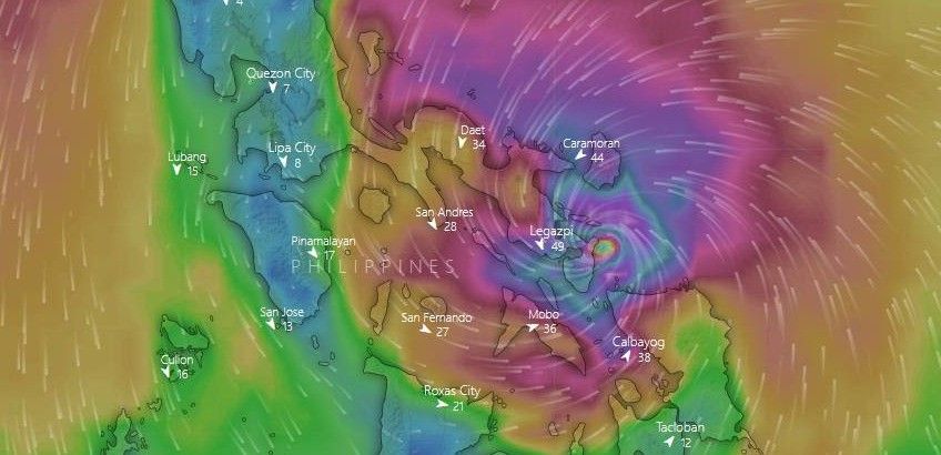
Rainfall amount in the Philippines for the past hour. pic.twitter.com/6yASNlMdUM
— Mahar Lagmay (@nababaha) December 3, 2019
Heavy rainfall is characterized by 7.5-15 mm of rain in an hour equivalent to two gallons per square meter of water per hour.
Intense rainfall is 15-30 mm per hour of rain or four to eight gallons per square meter per hour of water.
Between late afternoon today and tomorrow morning
Frequent to continuous heavy (with isolated intense) rains over Mindoro Provinces, Metro Manila, Central Luzon, Rizal and Northern Quezon including Polillo Islands.
Occasional heavy rains over Cagayan Valley, Cordillera Administrative Region, Marinduque, Romblon and the rest of Calabarzon.
Intermittent heavy rains over Calamian Islands.
Where is Typhoon Tisoy now?
As of PAGASA's 8 a.m. severe weather bulletin, Typhoon Tisoy is now located just off the coast of Bondoc Peninsula, which is in the southeastern part of Quezon Province.
What to expect in areas near the eyewall?
The typhoon's eyewall, its most dangerous and destructive part, is currently bringing violent winds and heavy to intense rainfall over southern Quezon, Marinduque and Romblon.
Within three hours, this eyewall is forecast to affect Cavite, Batangas and the northern portion of Mindoro Provinces.
Where is it headed next?
The eye is expected to make landfall or pass close to the Marinduque-Simara Island-Banton Island area before noon.
Work is suspended for Tuesday, December 3, at the House of Representatives due to Typhoon Tisoy.
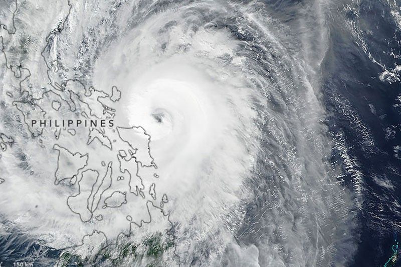
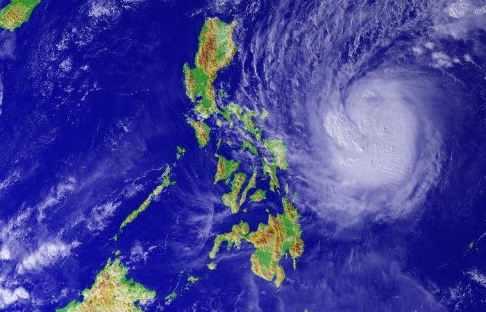
The NASA Earth Observatory shows an image of Typhoon Tisoy (international name: Kammuri) as it approaches landfall on Monday, December 2.
The image was acquired by the Visible Infrared Imaging Radiometer Suite (VIIRS) on the NOAA-NASA Suomi NPP satellite.
A News5 reporter on the ground showed scenes in Gumaca, Quezon which is being lashed by strong winds and rain brought by the typhoon.
Around 2,800 residents there are now in evacuation centers.
The slightly weakened but still "powerful" Typhoon Tisoy is now over Burias Island but due to its vast diameter, PAGASA says very strong winds and rainfall are still being felt over virtually the entire Bicol, Southern Luzon and the northern part of Eastern Visayas.
"The eyewall of 'Tisoy' is currently bringing violent winds and intense rainfall over Camarines Norte, Camarines Sur, Albay, and Masbate. This eyewall is forecast to affect Southern Quezon, Romblon and Marinduque in the next 3 hours," the state weather bureau says in its 5 a.m. weather bulletin.
Typhoon Tisoy has made landfall in Gubat, Sorsogon at 11 p.m., PAGASA says in an 11:30 p.m. advisory.
Before hitting land, the tropical cyclone gained intensity with sustained winds of up to 175 kilometers per hour near the center and gustiness of up to 240 kph. It is moving at 15 kph.
Tisoy is currently bringing violent winds and intense to torrential rainfall over Northern Samar, Catanduanes, Albay, Camarines Sur and Sorsogon. PAGASA also warns Camarines Norte and Masbate will be affected by the eyewall in the next 2-3 hours. (Image by Windy)
Typhoon Tisoy (international name Kommuri) further intensifies as it approaches Sorsogon where it is forecast to make landfall.
"The eyewall of Typhoon 'TISOY' is now bringing violent winds over Northern Samar, Catanduanes, Albay, Camarines Sur, and Sorsogon," state weather bureau PAGASA reports in its 8 p.m. advisory.
Metro Manila, meanwhile, is bracing for the expected "frequent to continuous heavy to intense rains" brought by Tisoy on Wednesday, December 2. Storm warning Signal No. 2 has been raised over the flood-prone capital region.
The Ninoy Aquino Internation Airport's terminals will be closed from 11 a.m. to 11 p.m. on Tuesday, December 3, in anticipation of "disruptive winds" brought by Typhoon Tisoy.
According to an ABS-CBN News report, the closure could affect more than 400 flights.
PAGASA warns that Typhoon Tisoy increases its threat as it moves closer towards the northern Samar, Albay and Sorsogon area. The typhoon is forecast to make landfall over Catanduanes, Albay or Sorsogon between tonight and tomorrow early morning.
The state weather bureau says there is a heavy rainfall outlook until this afternoon with occasional heavy rains seen over Bicol, Samar Provinces and Biliran.
Meanwhile, intermittent heavy rains are expected over northern Cebu, northern Negros Island, Dinagat Islands, Siargao Island and the rest of Eastern Visayas.
PAGASA also warns residents in storm surge-prone areas of possible storm surges of more than three meters in heaight over several coastal areas in Camarines Norte (Mercedes and Mandao), Camarines Sur (Cabusao, Bombon, Calabanga, Tinambac, and Sipocot) and Catanduanes (Bagamanoc, Baras, Bato, Viga, Panganiban and Gigmoto).
Storm surges with heights of one to three meters over several coastal areas are also forecast in Quezon, Camarines Norte, Camarines Sur, Catanduanes and Samar.
As of 1 p.m. today, "Tisoy" packs maximum sustained winds of 150 kph near the center and gustiness of up to 185 kph.
PAGASA says Typhoon Tisoy slightly intensifies as it barrels westward toward Catanduanes or Albay where it is forecast to make landfall between tonight and tomorrow early morning.
The center of "Tisoy" was located based on all available data at 355 km east of Virac, Catanduanes at 4 a.m. today.
It packs maximum sustained winds of up to 150 kph near the center and gustiness of up to 185 kph.
The Philippines has begun evacuating thousands of people, local officials said Sunday, as a powerful typhoon rumbling in from the Pacific forced Southeast Asian Games organizers to cancel or reschedule some events.
Forecasters expect Typhoon Tisoy (Kammuri) to make landfall Monday evening or Tuesday morning, packing gusts of 170 kilometers (105 miles) per hour and maximum sustained winds of 140 kph.
The storm entered Philippine territory Saturday evening, shortly before President Rodrigo Duterte and boxing superstar Manny Pacquiao launched the Games with a colorful opening ceremony.
This year's Games in Clark, Manila and Subic, which run through to December 11, are already particularly complex with a record 56 sports across dozens of venues that are in some cases hours apart by car. -- Agence France-Presse
'Tisoy' has weakened, PAGASA says in a media briefing carried by dzBB on Sunday afternoon.
It is seen to weaken even more when it reaches the Bicol region. Residents should still take precautions against heavy rain that the typhoon will bring.
Tropical Cyclone Wind Signal No. 1 is up over the following areas as Typhoon Tisoy maintains strength
and continues moving westward:
- Catanduanes
- Albay
- Sorsogon
- Camarines Sur
- Masbate, including Burias and Ticao Island
- Samar
- Northern Samar
- Eastern Samar
- Biliran
- Camotes Island and Leyte
According to PAGASA early Sunday morning, "Tisoy" was 885 km east of Virac, Catanduanes early Sunday morning. The typhoon is moving west at 15 kph and has maximum sustained winds of 150 kph near the center. It has gustiness of up to 185 kph.
PAGASA says Typhoon Kammuri, locally named "Tisoy" has entered the Philippine Area of Responsibility as of 4 p.m. Saturday.
PAGASA says Typhoon Kammuri slightly slows down as it maintains strength outside the Philippine Area of Responsibility.
The eye of the typhoon was located at 1,220 kilometers east of southern Luzon.
It has maximum sustained winds of 150 kilometers per hour near the center and gusts of 185 kilometers per hour. "Kammuri" is moving west southwest at 15 kilometers per hour.
Typhoon Kammuri intensifies further, PAGASA says. It is less likely to strengthen into a super typhoon but the possibility is not ruled out by the state weather bureau.
"Kammuri" is now packing maximum sustained winds of 140 kph and gusts of 170 kph.
At 10 a.m. today, the center of the typhoon was located 1,470 km east of southern Luzon outside the Philippine area of responsibility.
Tropical Cyclone Wind Signal No. 1 may be raised over the eastern portion of Bicol-Eastern Visayas area on Sunday when the typhoon is expected to be inside the Philippine area of responsibility. "Kammuri" is forecast to enter PAR between Saturday and Sunday morning and will be named "Tisoy."
Typhoon Kammuri slightly strengthens in the past 12 hours and is likely to further intensify before it enters the Philippine area of responsibility.
It was located 1,350 km east of southern Luzon, PAGASA says in its 4 a.m. update.
"Kammuri" packs maximum sustained winds of 130 kph and gustiness of up to 160 kph. It is moving west at 25 kph.
Severe Tropical Storm Kammuri intensifies into a typhoon, PAGASA says. The typhoon is expected to enter the Philippine area of responsibility on Saturday evening or Sunday morning and is seen to make landfall over Bicol or Aurora area by Tuesday.
PAGASA forecasts that "Kammuri" will bring moderate to heavy rains from Sunday to Wednesday. The typhoon will affect Central Luzon, Metro Manila and Southern Luzon where most of the SEA Games sports events will be held. — The STAR/Elizabeth Marcelo
Monitor updates on Typhoon Tisoy (international name: Kammuri), the 20th tropical cyclone to hit the country in 2019.


- Latest
- Trending


