Typhoon Chedeng intensifies; enhanced habagat to bring rains in western Luzon, Visayas
MANILA, Philippines — Typhoon Chedeng intensifed in the middle of the Philippine Sea while the southwest monsoon or hanging habagat continues to bring cloudy and rainy weather in the western sections of Luzon and Visayas.
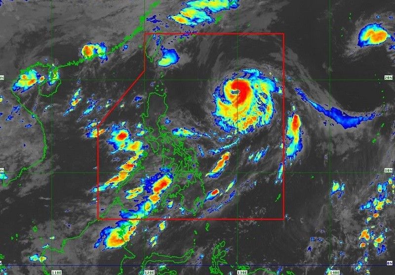
The center of the tropical cyclone was last seen 875 kilometers east of northern Luzon at around 4 a.m. Saturday, according to PAGASA.
- Maximum sustained winds: 150 kilometers per hour near the center
- Gustiness: up to 185 kilometers per hour
- Direction: north northwestward
- Movement: slow
"Chedeng is unlikely to directly bring heavy rainfall over the country in the next 3 days," said state meteorologists in a statement.
"However, the southwest monsoon may be enhanced by Chedeng and bring occasional rains over the western portions of Luzon and Visayas in the next 3 days."
While the hoisting of tropical cyclone wind signals is unlikely at this time, the enhancedment of habagat in the coming days may bring gusty conditions over the following areas on Saturday:
- Metro Manila
- CALABARZON
- Bicol Region
- Visayas
- Zambales
- Bataan
- Camiguin
- Dinagat Islands
The typhoon may also bring moderate to rough seas (2.0 to 3.5 meters) over the seaboards of extreme northern Luzon and the eastern seaboard of mainland northern Luzon, prompting PAGASA to advise mariners of small seacrafts to take caution when going out to sea.
"Chedeng will remain far from the Philippine landmass. It is forecast to move northward or north northeastward today. Tomorrow, the tropical cyclone will accelerate northeastward towards the sea southeast and east of the Ryukyu Islands," the state weather bureau added.
"It is forecast to leave the Philippine Area of Responsibility (PAR) between tomorrow late evening or on Monday early morning."
The cyclone is forecast to maintain its strength throughout the weekend before entering a weakening trend on Monday.
A possible slight intensification in the next 12 hours is no longer ruled out. It is projected to leave the PAR region as a typhoon.


- Latest
- Trending