


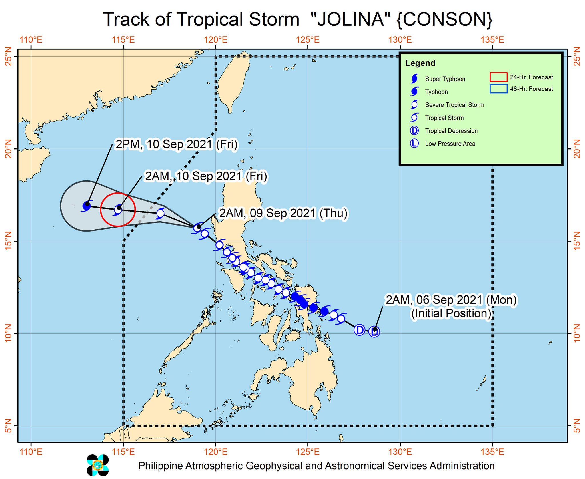
'Jolina' seen to exit PAR on Thursday; 'Kiko' continues to intensify
MANILA, Philippines — Severe Tropical Storm Jolina is forecast to exit the Philippine Area of Responsibility on Thursday afternoon or evening while Typhoon Kiko continues to intensify, state weather bureau PAGASA said.
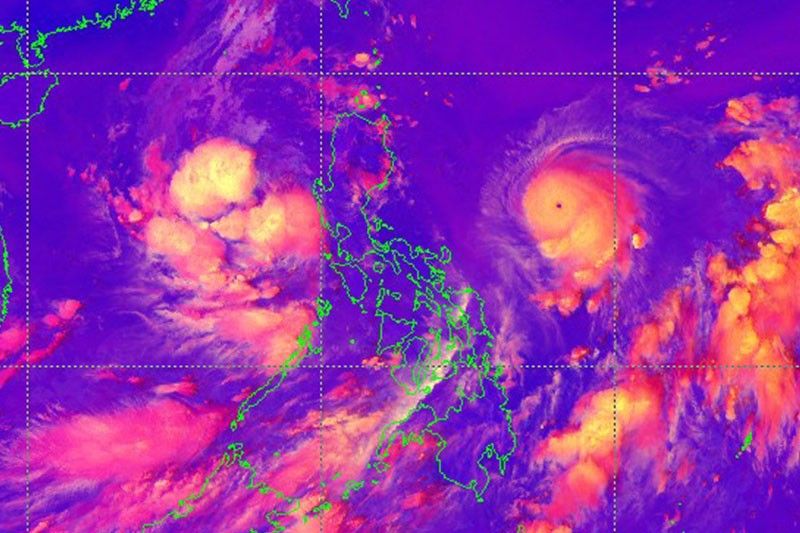
Jolina maintained its strength as it moves away from Luzon landmass. At 4 a.m., it was located 145 km west northwest of Iba, Zambales or 175 km west of Dagupan City, Pangasinan with winds of 85 kph and gusts of up to 115 kph. It is moving northwestward at 25 kph.
Tropical Cyclone Wind Signal no. 1 is hoisted over:
- the western portion of Pangasinan (Anda, Bolinao, Infanta, Aguilar, Sual, Labrador, Dasol, Bugallon, Burgos, Mabini, Agno, City of Alaminos, Bani, Lingayen, Mangatarem)
- the northern portion of Zambales (San Antonio, Botolan, San Narciso, San Felipe, Cabangan, Palauig, Iba, Masinloc, Candelaria, Santa Cruz)
What to expect
- Light to moderate with at times heavy rains over Zambales, Bataan and Pangasinan
- Strong winds (strong breeze to near gale conditions) with occasional gusts in areas under Signal No. 1
- Moderate to rough seas (1.5 to 4.0 m) over the western seaboard of Luzon
Forecast positions
- Friday morning: 605 km west of Dagupan City, Pangasinan (outside the PAR)
- Friday afternoon: 790 km west of Dagupan City, Pangasinan (outside the PAR)
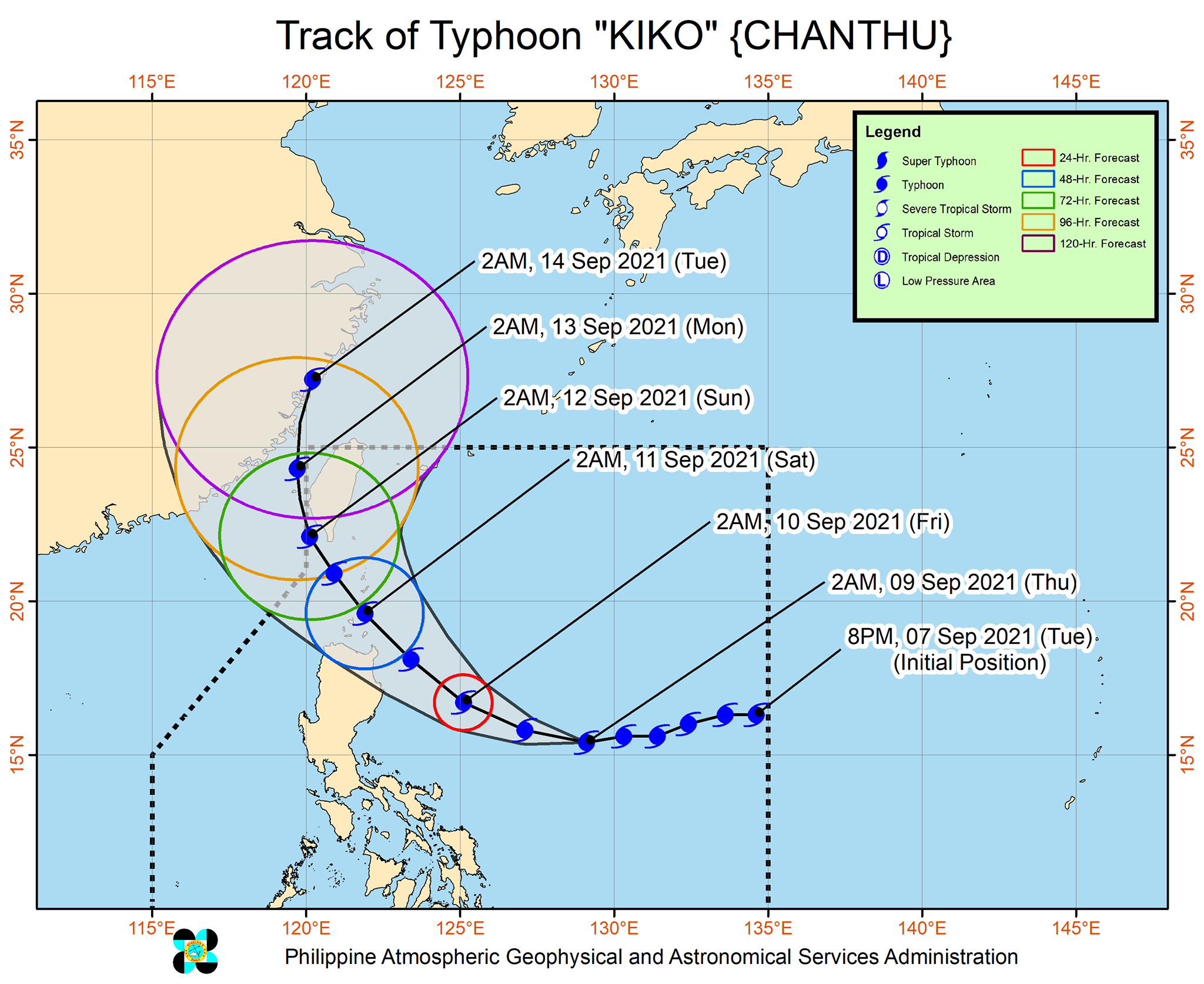
'Kiko' resumes intensification
Typhoon Kiko, meanwhile, is forecast to pass very close to northeastern Cagayan and cross the vicinity of Babuyan Islands between Friday afternoon and early Saturday morning.
"Given the recent southward shift in the track forecasts of “KIKO” from the previous bulletins, the possibility of landfall over mainland Cagayan is not yet ruled out," PAGASA said.
At 4 a.m., Kiko was located 785 km east of Baler, Aurora with winds of 185 kph and gusts of up to 230 kph. It is moving westward at 20 kph.
Tropical Cyclone Wind Signal no. 1 is raised over:
- the eastern portion of Cagayan (Buguey, Lal-Lo, Santa Teresita, Gonzaga, Santa Ana, Gattaran, Baggao, Peñablanca)
- the northeastern portion of Isabela (Maconacon, Divilacan, San Pablo, Cabagan, Palanan)
What to expect
- Heavy to intense with at times torrential rains over Batanes, Cagayan including Babuyan Islands and northern Isabela
- Moderate to heavy with at times intense rains over Batanes and the rest of Isabela
- Winds reaching strong breeze to near gale in strength (i.e, strong winds) with occasional gusts will be experienced within 36 hours within the areas under Signal No. 1
- High waves near the coast and storm surge may affect several coastal municipalities in Northern Luzon
- Moderate to very rough seas (1.5 to 2.8 m) initially and becoming rough to very rough seas (2.5 to 5.0 m) will prevail over the eastern seaboard of Northern Luzon
- Moderate to rough seas (1.2 to 2.8 m) will be experienced over the northern seaboard of Northern Luzon and the eastern seaboards of Central and Southern Luzon
Forecast positions
- Friday morning: 320 km east of Casiguran, Aurora
- Saturday morning: Over the coastal waters of Babuyan Island, Calayan, Cagayan
- Sunday morning: 230 km northwest of Itbayat, Batanes
- Monday morning: 450 km north northwest of Itbayat, Batanes (outside the PAR)
- Tuesday morning: In the vicinity of Ningde, Fujian Province, China or 730 km north northwest of Itbayat, Batanes (outside the PAR)

Follow this page for updates on Kiko, the 11th tropical cyclone to enter the Philippines on 2021. — Main photo from JTWC
Typhoon Chanthu unleashed powerful winds and heavy rain on eastern Taiwan Sunday, disrupting travel links and cutting electricity to some homes but sparing the island a direct hit.
Downgraded from a super typhoon since its rapid formation last week, the outer edges of Chanthu pounded the eastern coastline. But the centre of the storm remained out to sea as it moved north, the central weather bureau said.
The eastern regions of Hualien and Taitung have received some 8 inches of rain so far, the bureau added. Waves of up to seven meters were recorded on Orchid Island off Taiwan's eastern coast.
A total of 159 domestic and international flights have been cancelled due to the typhoon, the central emergency operation centre said. All ferry services to offshore islands were also suspended, along with some train routes.
Around 26,000 households have lost power, authorities added. — AFP
PAGASA says Typhoon Kiko has weakened further as it continued to move over the coastal waters of Itbayat, Batanes.
The center of the eye of Typhoon Kiko was spotted over the coastal waters of Itbayat, Batanes. It has maximum sustained winds of 195 kilometers per hour near the center, gustiness of up to 240 kph.
PAGASA says Typhoon Kiko has slightly weakened and is now moving over the coastal waters of Itbayat, Batanes.
PAGASA says Typhoon Kiko made a landfall over Ivana, Batanes at 8:30 a.m. Saturday.
Typhoon Kiko slightly intensifies as it continues to threaten extreme northern Luzon, state weather bureau PAGASA says.
At 10 a.m., the typhoon was located 220 km northeast of Casiguran, Aurora or 220 km east of Tuguegarao City, Cagayan, packing winds of 195 kph and gusts of 240 kph.
Signal No. 3 is still hoisted over parts of Cagayan and Babuyan Islands.


- Latest
- Trending


