Signal No.2 in parts of Luzon due to 'Dante'
Signal No. 1 in Metro Manila
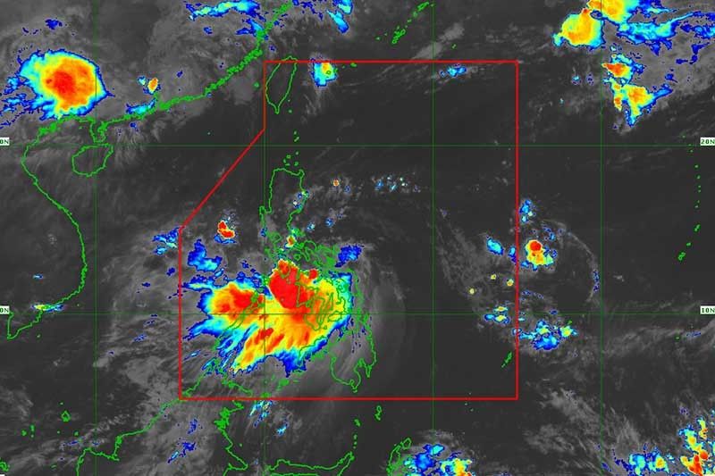
MANILA, Philippines (Updated 12:47 p.m.) — Parts of Luzon are placed under storm signals as Tropical Storm Dante (Choi-wan) approaches the eastern coast of Oriental Mindoro, state weather bureau PAGASA said.
In a bulletin issued at 11 a.m., PAGASA said “Dante” was seen over the northwestern coastal waters of Romblon, Romblon or 115 kilometers southeast of Calapan City, Oriental Mindoro.
It is packing maximum sustained winds of 65 km per hour (kph) near the center and gusts of up to 90 kph. It is heading northwest at 25 kph.
“Dante” has so far made five landfalls: over Sulat in Eastern Samar, Cataingan and Balud in Masbate, and Romblon and San Agustin in Masbate.
According to the National Disaster Risk Reduction and Management Council, three people were reported dead during the onslaught of “Dante.”
Wind signals
Tropical Cyclone Wind Signal No. 2 (damaging gale-force winds prevailing or expected within 24 hours)
Luzon
• Romblon
• Marinduque
• Northern and central portion of Oriental Mindoro (Roxas, Bongabong, San Teodoro, Puerto Galera, Baco, City of Calapan, Naujan, Victoria, Socorro, Pola, Pinamalayan, Gloria, Bansud)
• Northern and central portion of Occidental Mindoro (Sablayan, Santa Cruz, Paluan, Mamburao, Abra de Ilog, Lubang Islands)
• Batangas
• Cavite
• Bataan
• Southwestern portion of Bulacan (Calumpit, Bulacan, City of Malolos, Paombong, Hagonoy)
• Western portion of Pampanga (Masantol, Macabebe, Sasmuan, Lubao, Floridablanca, Porac, Guagua, Santa Rita, Angeles City, Mabalacat City, Minalin, Bacolor)
• Zambales
• Western portion of Tarlac (Bamban, Capas, San Jose, Mayantoc, Camiling, Santa Ignacia, San Clemente)
• Western portion of Pangasinan (Bolinao, Anda, Bani, Agno, Burgos, Infanta, Dasol, City of Alaminos, Mabini, Sual, Labrador, Bugallon, Aguilar, Mangatarem, Bayambang, Urbiztondo, Basista, Malasiqui, San Carlos City, Santa Barbara, Mangaldan, Dagupan City, Calasiao, Binmaley, Lingayen)
Tropical Cyclone Wind Signal No. 1 (strong winds prevailing or expected within 36 hours)
Luzon
• Northern portion of Palawan (Calamian Islands, Cuyo Islands)
• Rest of Oriental Mindoro
• Rest of Occidental Mindoro
• Western portion of Quezon (Lucena City, City of Tayabas, Pagbilao, Lucban, Sariaya, Candelaria, Dolores, Tiaong, San Antonio, Padre Burgos)
• Western and central portion of Laguna (Luisiana, Pagsanjan, Santa Cruz, Majayjay, Magdalena, Liliw, Nagcarlan, Pila, Victoria, Rizal, San Pablo City, Calauan, Bay, Alaminos, Los Baños, City of Calamba, Cabuyao City, City of Santa Rosa, City of Biñan, City of San Pedro)
• Metro Manila
• Rizal
• Rest of Bulaca
• Rest of Pampanga
• Rest of Tarlac,
• Western portion of Nueva Ecija (Cabiao, San Antonio, City of Gapan, San Isidro, San Leonardo, Jaen, Zaragoza, Licab, Guimba, Cuyapo, Nampicuan, Talugtug, Quezon, Aliaga, Santa Rosa)
• Rest of Pangasinan
• Southern portion of Benguet (Itogon, Tuba, Sablan, Baguio City, La Trinidad, Kapangan, Tublay)
• La Union
Visayas
• Aklan
• Capiz
• Northern portion of Antique (Valderrama, Bugasong, Laua-An, Barbaza, Tibiao, Culasi, Sebaste, Pandan, Libertad, Caluya)
• Northwestern portion of Iloilo (Lambunao, Calinog, Bingawan)
What to expect
PAGASA said "Dante" may pass near or in the vicinity of Oriental Mindoro or southwestern portion of Batangas before making another landfall over Bataan Wednesday evening.
It will then cross Zambales and Pangasinan, and emerge over the West Philippine Sea Thursday morning.
"Dante" is also forecast to maintain its strength until it makes another landfall over mainland Luzon. But land interaction with the rugged terrain of the island will weaken it into a tropical depression.
The state weather bureau said the tropical storm will bring moderate to heavy with at times intense rains over the following areas:
• Calabarzon
• Romblon
• Marinduque
• Occidental Mindoro
• Oriental Mindoro
• Aklan
• Antique
• Capiz
• Iloilo
• Guimaras
• Zambales
• Bataan
Moderate to heavy rains are expected over:
• Tarlac
• Pampanga
• Bulacan
• Metro Manila
• Northern portion of Palawan including Calamian, Cuyo, and Cagayancillo Islands
• Negros Occidental.
Meanwhile, light to moderate with at times heavy rains will affect:
• Rest of Central Luzon
• Benguet
• Nueva Vizcaya
• Quirino
• Rest of MIMAROPA,
• Negros Oriental, and Cebu including Camotes and Bantayan Islands
Rough to very rough seas (2.5 to 4 meters)
• Seaboards of areas where Signal No. 2 is in effect
• Remaining seaboards of Bicol region
Moderate to rough seas (1.2 to 3 meters)
• Seaboards of areas where Signal No. 1 is in effect
• Remaining seaboards of Bicol region
• Remaining seaboards of Visayas
• Caraga
• Northern seaboard of Northern Mindanao
• Eastern seaboard of Davao Oriental
The Philippine Institute of Volcanology and Seismology also said “Dante” can be expected to generate volcanic sediment flows or lahars, muddy streamflows or muddy run-off in rivers and drainage areas of Taal and Pinatubo volcanoes.
PAGASA estimated that one to three tropical cyclones may enter the Philippine Area of Responsibility in June.


- Latest
- Trending