


PAGASA: Tonyo now over Occidental Mindoro
MANILA, Philippines — After first making landfall over San Juan, Batangas on Sunday morning, Tropical Depression Tonyo has slightly accelerated and is now over coastal waters in Paluan, Occidental Mindoro, weather forecasters said.
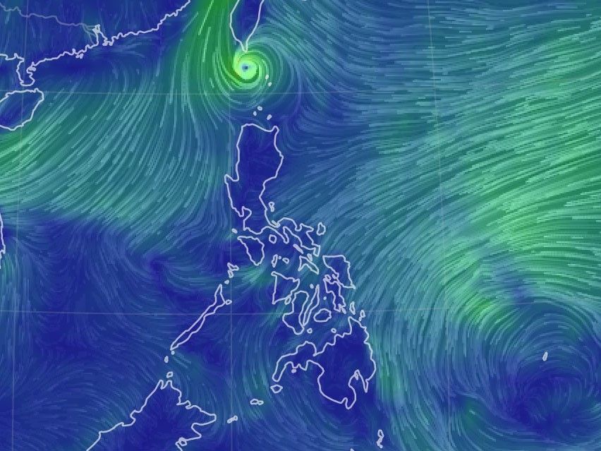
In its latest update 2 p.m., state weather bureau PAGASA said that Tonyo was last recorded in the vicinity of 105 km west of Calapan City, Oriental Mindoro, moving westward at 30 kph and packing peak winds of up to 45 kph at its core.
"Tonyo will emerge over the West Philippine Sea this morning or afternoon and exit the Philippine area of responsibility tomorrow morning. 'Tonyo' is forecast to intensify into tropical storm within the next 24 hours," PAGASA said.
Only the northwestern portion of Occidental Mindoro (Abra de Ilog, Paluan, Mamburao, Santa Cruz) including Lubang Island remain under Tropical Cyclone Wind Signal No. 1, where winds of 30-60 kph may still be expected in at least 36 hours or intermittent rains may be expected within 36 hours.
The bureau also warned of moderate to rough seas in the affected areas and urged mariners of small seacrafts to take precautionary measures when out at sea.
Tonyo is also forecast to intensify into a tropical storm within the next 24 hours, PAGASA said.
Forecast positions
- Monday morning: 735 km West of Calapan City, Oriental Mindoro, outside of Philippine area of responsibility
- Tuesday morning: 1,110 km West of Southern Luzon, outside of Philippine area of responsibility
The Northeast Monsoon will also bring a strong breeze to near gale conditions over Batanes, Babuyan Islands, Ilocos Norte, Apayao, and the northern portion of mainland Cagayan, PAGASA also said.
"At 1:00 PM today, a Low Pressure (LPA) was estimated at 920 km East of Hinatuan, Surigao del Sur...It may develop into tropical depression "Ulysses" within the next 48 hours."
— Franco Luna


Tropical Depression Tonyo has made landfall over Torrijos, Marinduque at 4:30 a.m. on Sunday, state weather bureau PAGASA says.
The weather bureau forecasts Tonyo to move west-northwestward and make landfall in the vicinity of Sariaya, Quezon or San Juan, Batangas.
At 7 a.m., Tonyo was locate 70 km southwest of Alabat, Quezon or 40 km south southwest of Tayabas, Quezon. It bears winds of 45 kph and gusts of up to 60 kph. It is moving west northwestward at 25 kph.
All tropical cyclone warning signals have been lifted as Tropical Depression Tonyo moves over the West Philippine Sea on Sunday afternoon.
The weather disturbance is forecast to exit the Philippine Area of Responsibility on Monday morning.
At 4 p.m., Tonyo was seen 185 km west of Calapan City, Oriental Mindoro with maximum sustained winds of 45 kph and gustiness of up to 55 kph. It is moving southwestward at 25 kph.
Tropical Depression Tonyo is forecast to intensify into a tropical storm within the next 24 hours as it moves to exit the Philippine area of responsibility.
At 1 p.m., Tonyo was located 105 km west of Calapan City, Oriental Mindoro, bearing winds of 45 kph and gusts of 60 kph. It is moving west at 30 kph.
Signal No. 1 is still hoisted over the northwestern portion of Occidental Mindoro (Abra de Ilog, Paluan, Mamburao, Santa Cruz) including Lubang Island.
Tropical Depression Tonyo has made landfall over San Juan, Batangas at around 8 a.m. on Sunday.
State weather bureau PAGASA says the cyclone will emerge over the West Philippine Sea Sunday morning or afternoon and exit the Philippine Area of Responsibility by Tuesday morning.
At 10 a.m., Tonyo was located in the vicinity of Lobo, Batangas with maximum sustained winds of 45 kph and gusts of up to 60 kph. It is moving west northwestwards at 25 kph.
Tropical cyclone wind signal no. 1 is raised in:
- the northern and central portions of Quezon (Gumaca, Pitogo, Quezon, Alabat, Perez, Unisan, Plaridel, Atimonan, Agdangan, Padre Burgos, Pagbilao, Mauban, Tayabas City, Lucena City, Sariaya, Candelaria, Tiaong, San Antonio, Dolores, Lucban, Sampaloc, Real, Infanta, General Nakar) including Polillo Islands
- Cavite
- Laguna
- Rizal
- Batangas
- Metro Manila
- Bataan
- Bulacan
- Pampanga
- the southern portion of Aurora (Dingalan)
- the southern portion of Zambales (San Marcelino, San Felipe, San Narciso, San Antonio, Castillejos, Subic, Olongapo City)
- Marinduque
- the northern portion of Romblon (Romblon, San Andres, Calatrava, San Agustin, Corcuera, Banton, Concepcion)
- the northern and central portions of Oriental Mindoro (Bongabong, Bansud, Gloria, Pinamalayan, Socorro, Pola, Naujan, Victoria, Calapan City, Baco, San Teodoro, Puerto Galera)
- the northern and central portions of Occidental Mindoro (Sablayan, Santa Cruz, Mamburao, Paluan, Abra de Ilog) including Lubang Island


- Latest
- Trending


