


'Ramon' maintains strength as it inches towards Babuyan islands
MANILA, Philippines — Typhoon Ramon maintains its strength as it continues to slowly head towards the Babuyan Islands, where it is expected to make landfall.
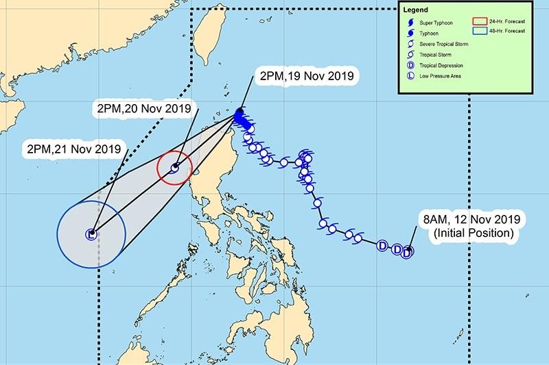
In its 5:00 p.m. bulletin, Pagasa located “Ramon” (international name: Kalmaegi) at 120 km east of Calayan, Cagayan.
It packs maximum sustained winds 120 kph, near the center and gustiness of up to 165 kph.
“Ramon” is expected to hit Babuyan Islands between Tuesday night and Wednesday morning. It is expected to weaken due to land interaction and the northeast monsoon or “Amihan.”
Pagasa warned of “moderate with frequent heavy rains over Batanes, northern portion of Cagayan including the Babuyan Islands, Apayao and the northern portion of Ilocos Norte,” on Tuesday night.
Light to moderate with intermittent heavy rains are expected over the northern portion of Isabela, Kalinga, Abra and the rest of Cagayan and Ilocos Sur.
The state weather bureau also said that there is possible storm surge of up to two meters in height in surge prone areas in La Union and Pangasinan.
Tropical Cyclone Wind Signals
Signal No. 3
- Northern portion of Cagayan:
- Santa Praxedes
- Claveria
- Sanchez Mira
- Pamplona
- Abulug
- Ballesteros
- Aparri
- Calayan
- Camalaniugan
- Buguey
- Santa Teresita
- Gonzaga
- Santa Ana
Signal No. 2
- Batanes
- Apayao
- Kalinga
- Abra
- Ilocos Norte
- Ilocos Sur
- The rest of Cagayan
Signal No. 1
- Northern portion of Isabela:
- Sta. Maria
- San Pablo
- Maconacon
- Cabagan
- Sto. Tomas
- Quezon
- Delfin Albano
- Tumauini
- Divilacan
- Quirino
- Roxas
- Mallig
- San Manuel
- Burgos
- Gamu
- Ilagan City
- Mountain Province
- Benguet
- Ifugao
- La Union
- Pangasinan
Pagasa reminded residents in areas that will be affected by “Ramon” to take appropriate actions, coordinate with local disaster risk reduction and management offices and continue monitoring updates.
It also said that sea travel is deemed risky, especially for small seacrafts in areas with tropical cyclone wind signals and the western seaboard of Zambales and Bataan due to forecast rough sea conditions.
Forecast positions:
- 24 hours (Wednesday afternoon): 140 km West Northwest of Dagupan City, Pangasinan
- 48 hours (Thursday afternoon): 210 km North Northeast of Pagasa Island, Palawan
Meanwhile, Pagasa is also monitoring Tropical Depression Sarah was last located 630 kilometers east north east of Borongan, Eastern Samar.
It packs wind of up to 65 kilometer per hour near the center and gustiness of up to 70 kph. "Sarah" is forecates to bring cloudy skies with scattered rains and thunderstorms over Bicol Region and Eastern Visayas on Wednesday. — Kristine Joy Patag


- Latest
- Trending


