Signal No. 3 in three northern Luzon areas as ‘Rosita’ approaches land
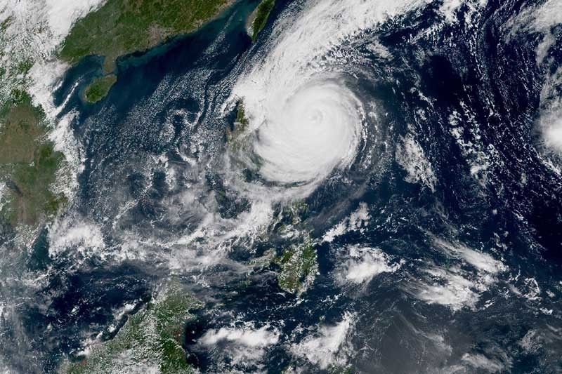
MANILA, Philippines (Updated 2:59 p.m.) — Signal No. 3 has been hoisted over three areas in northern Luzon as typhoon Rosita (international name: Yutu) moves closer to the Philippine landmass.
State weather bureau PAGASA placed Isabela, Quirino and northern Aurora under Signal No. 3. Residents of these areas may expect winds of greater than 121 kilometers per hour up to 170 kph in at least 18 hours.
Rosita—the 18th tropical cyclone this year and the second this month—is forecast to make landfall over the southern Isabela and northern Aurora area Tuesday morning. It will traverse the provinces of Aurora, Isabela, Quirino, Ifugao, Nueva Vizcaya, Benguet and La Union.
The typhoon will bring moderate to heavy rains over northern and central Luzon beginning Monday night.
PAGASA also raised tropical cyclone warning signals in the following areas:
Signal No. 2 (winds of 61 to 120 kph expected in at least 24 hours)
- Cagayan
- Abra
- Kalinga
- Ilocos Sur
- Mountain Province
- Ifugao
- La Union
- Benguet
- Nueva Vizcaya
- Pangasinan
- Tarlac
- Nueva Ecija
- Northern Quezon including Polillo Island
- Southern Aurora
Signal No. 1 (winds of 30 to 60 kph expected in at least 24 hours)
- Southern Quezon
- Ilocos Norte
- Apayao
- Batanes and Babuyan group of islands
- Zambales
- Rizal
- Pampanga
- Bulacan
- Metro Manila
- Laguna
- Batangas
- Bataan
- Cavite
- Camarines Norte
The state weather bureau warned that residents of areas under Signal Nos. 2 and 3 will experience stormy weather. Travel by land is dangerous in these areas.
Storm surge of up to three meters is possible over the coastal areas of Isabela, Cagayan, Aurora, Ilocos Sur, Ilocos Norte and La Union.
As of 1 p.m. today, the eye of Rosita was located 355 km east northeast of Casiguran, Aurora.
Its maximum sustained winds near the center weakened to 150 kph from the previous 170 kph. The gusts of the typhoon also decreased to 185 kph from the previous 210 kph.
Moving west southwest at 15 kph, Rosita will likely exit landmass by Tuesday afternoon. It is expected to leave the Philippine area of responsibility by Wednesday evening.
Forecast positions
- Tuesday morning: In the vicinity of San Agustin, Isabela
- Wednesday morning: 250 km west southwest of Sinait, Ilocos Sur
- Thursday morning: 445 km west northwest of Sinait, Ilocos Sur (outside PAR)
- Friday morning: 560 km west northwest of Laoag City, Ilocos Norte (outside PAR)
- Saturday morning: 640 km west northwest of Laoag City, Ilocos Norte (outside PAR)
— Gaea Katreena Cabico


- Latest
- Trending