


Typhoon Ompong enters PAR
MANILA, Philippines (Updated 4:30 p.m.) — Typhoon Ompong (international name: Mangkhut)—dubbed by weather officials as the “strongest to hit the country this year”—entered the Philippine area of responsibility Wednesday afternoon.
Ompong entered the country’s jurisdiction at 3 p.m., state weather bureau PAGASA said.
PAGASA earlier said that Tropical Cyclone Warning Signal Number 1 may be hoisted over all of eastern Luzon as early as Wednesday afternoon.
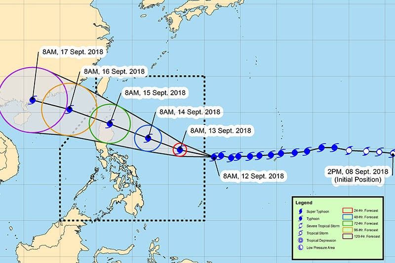
As of 8 a.m., “Mangkhut” was located 1,190 kilometers east-northeast of Guiuan, Eastern Samar.
It bears maximum sustained winds of 205 kilometers per hour near the center from the previous 200 kilometers per hour. Its gustiness increased up to 255 kilometers per hour from the previous 245 kilometers per hour.
Department of Science and Technology Undersecretary Renato Solidum urged the public and local government units to be vigilant.
“Mangkhut is so far the strongest tropical cyclone to enter the Philippines this year. Let us prepare for this,” Solidum said in a press briefing.
Senior weather specialist Christopher Perez warned of “very strong winds, storm surges over coastal areas and heavy to intense rains, particularly in Cagayan and Isabela by Friday and Northern Luzon by Saturday.
Mangkhut is expected to bring storm surge up from five to six meters upon its landfall in Cagayan.
Mangkhut is also expected to boost the southwest monsoon, which will bring occasional moderate to heavy rains in:
- Zamboanga Peninsula
- Northern Mindanao
- Siquijor
- Surigao del Norte
- Agusan del Norte
- Dinagat Island
- Lanao del Sur
- Palawan
- Bicol region
- Eastern Visayas
- Palawan
- Zamboanga Peninsula
- Western Visayas
- Central Visayas
- Palawan
- Western Visayas.
The rest of Luzon and Metro Manila may be affected by light to moderate rains with instances of occasional heavy rains with occasional gusty winds starting Friday.
Forecast positions
- Thursday morning: 805 kilometers east of Virac, Catanduanes
- Friday morning: 605 kilometers east of Baler, Aurora
- Saturday morning: vicinity of Aparri, Cagayan
- Sunday morning: 590 kilometers west of extreme Northern Luzon (Outside PAR)
- Monday morning: 1,125 kilometers west of extreme Northern Luzon (Outside PAR)
Related video:


- Latest
- Trending


