'Ada' weakens but monsoon risks remain

MANILA, Philippines — Tropical cyclone "Ada" (international name Nokaen) has weakened into a tropical depression, but monsoon-enhanced winds and hazardous sea conditions may continue to affect several areas, the state weather bureau said.
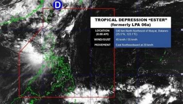
In its 5 a.m. bulletin on Monday, January 19, weather bureau PAGASA said the center of Tropical Depression Ada was located about 380 kilometers east of Casiguran, Aurora, as of 4 a.m.
Ada is packing maximum sustained winds of 55 kilometers per hour, gusts of up to 70 kph, and a central pressure of 1,000 hPa. It is moving north-northeastward at 10 kph.
No tropical cyclone wind signal is currently hoisted.
Areas at risk from 'severe' winds
PAGASA said the northeast monsoon, enhanced by Ada’s circulation, will bring strong to gale-force gusts, especially in coastal and upland areas exposed to winds.
Monday, January 19
- Batanes
- Cagayan
- Isabela
- Quirino
- Ilocos Norte
- Abra
- Aurora
- Polillo Islands
- Camarines Norte
- Camarines Sur
- Catanduanes
- Northern Samar
Tuesday, January 20
- Batanes
- Cagayan
- Isabela
- Ilocos Norte
- Abra
- Aurora
- Quezon
- Marinduque
- Romblon
- Camarines Norte
- Camarines Sur
- Catanduanes
- Albay
- Sorsogon
- Northern Samar
- Surigao del Sur
Wednesday, January 21
- Cagayan Valley
- Ilocos Region
- Abra
- Aurora
- Bulacan
- CALABARZON
- MIMAROPA
- Bicol Region
- Northern Samar
- Eastern Samar
- Negros Occidental
- Negros Oriental
- Cebu
- Antique
- Aklan
- Iloilo
- Guimaras
- Dinagat Islands
- Surigao del Sur
- Agusan del Norte
- Davao Oriental
Track and outlook
The weather bureau said Ada is forecast to move generally northeastward before following a looping track over the sea east of Luzon.
“Continuous dry air entrainment from the northeast monsoon is expected to result in gradual weakening,” PAGASA said, adding that Ada may weaken into a low-pressure area by Wednesday, though earlier weakening remains possible.
Rough seas expected
PAGASA said rough to moderate seas are expected over several coastal waters in the next 24 hours, even though no gale warning is in effect.
Sea conditions of up to 4.0 meters are expected along the eastern seaboards of Isabela and mainland Cagayan. Waves of up to 3.5 meters may affect the eastern seaboards of Batanes and the Babuyan Islands, northern Aurora, the Polillo Islands, and the northern seaboards of Camarines Norte, Camarines Sur, and Catanduanes.
Waves of up to 3.0 meters are forecast over Ilocos Norte and Ilocos Sur, western Pangasinan, eastern Catanduanes, and the remaining seaboards of Batanes and the Babuyan Islands.
PAGASA advised small seacrafts and motorbancas not to venture out to sea under these conditions, especially if ill-equipped or inexperienced. — with Ian Laqui


- Latest
- Trending