


China vessel ‘dangerously’ blocks Philippines patrol ship
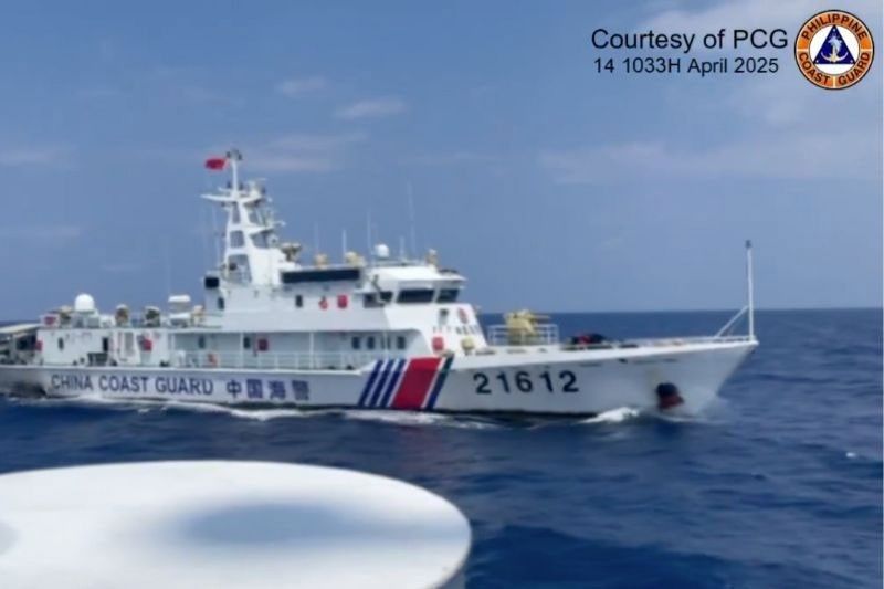
MANILA, Philippines — A China Coast Guard ship made a dangerous maneuver to block a Philippine Coast Guard (PCG) vessel on patrol off Zambales on Monday.
In a report yesterday, the PCG said the incident occurred 132.97 nautical miles west-southwest of Capon Grande, Zambales or about 36.35 nautical miles south of Bajo de Masinloc or Panatag shoal in the West Philippine Sea.
The Chinese vessel with bow number 21612 increased its speed and crossed the port side of the smaller BRP Cabra, blocking its navigation route, according to the PCG.
The maneuver was a violation of the International Regulations for Preventing Collisions at Sea, the PCG said.
Cabra, commanded by Lt. Cmdr. Hanna Yanez, continued its patrol within the country’s exclusive economic zone (EEZ).
PCG Commandant Adm. Ronnie Gil Gavan said the patrols were in accordance with international law, including the United Nations Convention on the Law of the Sea (UNCLOS), the 2016 arbitral award and the Philippine Maritime Zones Act.
The PCG said its patrols aim to assert Philippine jurisdiction and expose the aggressive behavior of Chinese vessels in the West Philippine Sea.
Also yesterday, PCG spokesman Commodore Jay Tarriela said the Coast Guard deployed an Islander aircraft to monitor a Chinese research vessel spotted northeast of Batanes.
The aircraft detected the Chinese vessel Zhong Shan Da Xue around 8 a.m. approximately 78 nautical miles northeast of Itbayat, Batanes.
The PCG aircraft attempted to establish radio communication with the vessel multiple times but received no response.
Tarriela said the PCG emphasized in its radio challenge that the Chinese ship’s activity was a violation of UNCLOS and the Philippine Maritime Zones Act.
Chinese drones?
The Philippine Navy, for its part, said least two of the five underwater drones recovered by fishermen in Philippine waters last year appear to have come from China and were supposedly being used to map underwater terrain in the country.
“There is a 55 to 80 percent likelihood that these deployed by the Chinese Communist Party. Why 55 to 80 percent is because of the components inside,” Philippine Navy spokesman for the WPS Rear Admiral Roy Vincent Trinidad told reporters yesterday.
“Not all of them have markings that they were made in China. Others are available commercially off the shelf. They have the capability to receive, to process, to store and to transmit data through satellite communications to a station on land, to a mothership or to other drones,” he said.
“We are not categorically stating where they came from, but there is a likelihood, a 55 to 80 percent likelihood, per the report,” Trinidad explained.
Over the past four years, drones had been recovered in Pasuquin, Ilocos Norte; Zambales; Calayan, Cagayan; Initao, Misamis Oriental and in San Pascual, Masbate.
Trinidad said one of the drones’ sensors had external Chinese markings with the integral chips or integrated chips inside sanitized or defaced and there was an iridium transceiver with serial number of HWA Create.
“HWA Create is a company that focuses on defense, civil, government and industrial solutions, the headquarters of which is in Beijing. There was a China Telecom SIM card. The information gathered focuses on bathymetric data. It also collects information on sound propagation underwater. All of this information have uses commercially, for scientific research, for academic purposes. They have also dual use for military use,” he said.
Trinidad said another had a battery assembly with markings of the 18th Research Institute of China Electronics Technology Group.
“The CETG Corporation or the China Electronics Technology Group Corporation is a state-owned enterprise for civil military integration of information technology. Likewise, the 18th Technology Group Research Institute of China of the CETG is the primary sub company of the CETG when it comes to integrating civil and military research,” he said.
Google Maps
Meanwhile, Google Maps has clarified that the West Philippine Sea label is not a new addition to its maps, but has just been “made easier to see” by users.
“The West Philippine Sea has always been labeled on Google Maps,” a Google spokesperson said in a message to The STAR. “We recently made this label easier to see at additional zoom levels.” — Michael Punongbayan, Janvic Mateo, Jose Rodel Clapano


- Latest
- Trending


