


Betty slows down, but will enhance monsoon
MANILA, Philippines — Typhoon Betty has weakened, but more than 200 millimeters of rain are expected in Northern Luzon and western section of Southern Luzon and Visayas as the former super typhoon enhances the habagat or southwest monsoon, affecting many areas in the country including Mindanao, according to the Philippine Atmospheric, Geophysical and Astronomical Services Administration (PAGASA).
At a press conference, PAGASA weather senior specialist Chris Perez said that while tropical cyclone wind signal No. 1 was hoisted in many areas, the weather bureau does not discount the possibility of raising the wind signal to No. 3.
“Many may ask, signal number one was raised in their areas, but there are no rains. We would like to remind the public that the effect of strong winds will be experienced starting tonight (Sunday) or tomorrow morning (Monday morning). We are not ruling out the possibility of signal number two as it is slowly moving southwest. The worst-case scenario is we will have wind signal three,” Perez said.
He added that Northern Luzon will be directly affected by Typhoon Betty (international name Mawar), while enhanced habagat will affect Southern Luzon, Visayas and Mindanao.
“Northern Luzon will experience more than 200 millimeters of rain in the next two to five days starting tomorrow (Monday) until Friday. On the other hand, in terms of habagat, the western section of Southern Luzon and Visayas will also experience the same amount of rain,” Perez warned.
He said that the combined strength of Betty and enhanced habagat will result in flooding and landslides, particularly in low-lying areas.
“The continuous rains will bring flooding in certain portion of Northern Luzon, Central and Southern Luzon and Visayas because of the combined effects of Typhoon Betty and enhanced habagat,” Perez said.
He said the state weather bureau does not see the typhoon making landfall, but it will affect the entire country because of its radius.
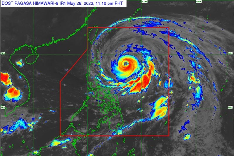
“Based on our satellite imagery, it is far from the land mass, but many areas will be covered by heavy clouds, bringing rains and strong winds,” Perez explained.
As of 11 a.m. on Sunday, tropical cyclone wind signal one was hoisted in Batanes, Cagayan including Babuyan Islands, Isabela, Apayao, Ilocos Norte, northern and central portions of Abra (Tineg, Lacub, Lagayan, San Juan, Lagangilang, Licuan-Baay, Malibcong, Danglas, La Paz, Dolores, Tayum, Bucay, Sallapadan, Daguioman, Bucloc, Boliney), Kalinga, eastern and central portions of Mountain Province (Sadanga, Barlig, Natonin, Paracelis, Bontoc), eastern and central portions of Ifugao (Mayoyao, Aguinaldo, Alfonso Lista, Banaue, Hingyon, Lagawe, Lamut, Kiangan, Asipulo), northern and central portions of Aurora (Dilasag, Casiguran, Dinalungan, Dipaculao), Quirino and the northeastern portion of Nueva Vizcaya (Kasibu, Quezon, Solano, Bagabag, Diadi, Villaverde, Bayombong, Ambaguio).
According to the weather bureau, the center of the eye of Typhoon Betty was located at 715 kms. east of Tuguegarao City, Cagayan. It has maximum sustained winds of 175 kilometers per hour near the center and gustiness of up to 215 km/h, as it is moving westward at 15 km/h.
The state bureau said that more than 200 millimeters of rain are expected in Batanes, Ilocos Sur, northern portion of La Union and northern portion Benguet, Babuyan Islands, Ilocos Norte and Abra from Wednesday morning to Thursday morning.
PAGASA said that monsoon rains are expected over the western portions of Mimaropa, Calabarzon and Central and Southern Luzon.
At the same time, PAGASA said a gale warning remains in effect over the northern and eastern seaboards of Northern Luzon, eastern seaboards of Central and Southern Luzon, and the eastern seaboards of Visayas and Mindanao.
“Typhoon Betty will move west northwestward or northwestward until tomorrow (Monday) while gradually decelerating. The typhoon will likely become slow-moving to almost stationary by Tuesday while over the waters east of Batanes. It will then move northward or north northeastward by mid Wednesday or Thursday towards the sea east of Taiwan,” the weather bureau added in its latest bulletin.
According to PAGASA, Typhoon Betty is expected to gradually weaken until Tuesday.
“Afterwards, increasingly unfavorable environment while moving northward or north northeastward on Wednesday or Thursday will result in a faster weakening rate. Typhoon Betty may be downgraded to severe tropical storm category on late Thursday or early Friday,” it added.
Under PAGASA’s tropical cyclone wind signal system, a super typhoon is declared if it has sustained winds of 185 km/h; typhoon, 118 to 184 km/h; severe tropical storm, 89 to 117 km/h; tropical storm, 62 to 88 km/h, and tropical depression at less than 61 km/h. — Ramon Efren Lazaro, Evelyn Macairan, Ralph Edwin Villanueva, Rainier Allan Ronda


- Latest
- Trending


