Super Typhoon Betty enters Philippine area of responsibility
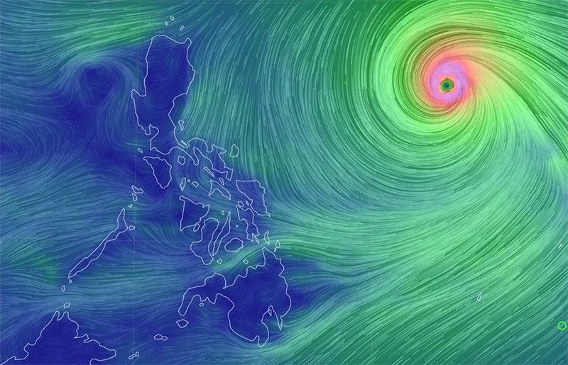
MANILA, Philippines — State weather bureau PAGASA said Super Typhoon Betty (international name: Mawar) entered the Philippine Area of Responsibility at 2 a.m. Saturday.
Mawar, which has been given the local name Betty, is the second tropical cyclone of 2023 and the first super typhoon of the year to enter PAR. Days ago, it made a direct hit on Guam, a US territory in the Pacific that is home to a crucial military outpost.
In its 5 a.m. Saturday advisory, Betty was located 1,320 kilometers east of Central Luzon with peak winds of 195 kilometers per hour near the center and gusts of up to 240 kph. It was moving west northwestward at 25 kph.
Tropical cyclone wind signals for Betty will be raised on Saturday night or Sunday morning.
What to expect
According to state weather forecasters, Betty is forecast to remain as a super typhoon over the weekend, generally maintaining its west northwest direction, then northwestward before slowing down.
It may eventually become "almost stationary" between late Tuesday and early Wednesday when it will be closest to Batanes.
"Although it will likely maintain its strength for the next 36-48 hours, short-term intensification is not ruled out, especially in the next 12 to 24 hours," PAGASA said.
"However, this tropical cyclone may begin weakening considerably on Monday or Tuesday during its slowdown period over the waters east of Batanes due to potential unfavorable conditions (e.g., effect of upwelling of cooler ocean water and dry air intrusion)," it added.
Rainfall forecast
PAGASA issued the following rainfall forecast in several areas:
Monday early morning to Tuesday early morning
- 50-100 mm: Batanes, Babuyan Islands, and the northern portions of mainland Cagayan, Ilocos Norte, and Apayao.
Tuesday early morning to Wednesday early morning
- Greater than 200 mm: Batanes
- 100-200 mm: Babuyan Islands, Ilocos Norte, Ilocos Sur, and La Union
- 50-100 mm: Cordillera Administrative Region and the northern portion of mainland Cagayan.
“Forecast rainfall are generally higher in elevated or mountainous areas,” PAGASA said.
For areas that will not be directly affected by the super typhoon, monsoon rains from the enhanced southwest monsoon are likely over the western sections of MIMAROPA, Visayas and Mindanao on Sunday.
On Monday and Tuesday, monsoon rains are likely over the western sections of MIMAROPA and Western Visayas, and possible in the remaining areas of these two regions.
PAGASA warned that flooding and rain-induced landslides are likely.
The enhanced southwest monsoon may also bring strong breeze to near-gale conditions with intermittent gusts starting late Sunday or early Monday in the Visayas, the eastern portions of Central Luzon and Southern Luzon, and the northern and eastern portions of Mindanao.
In the next 24 hours, PAGASA said that the eastern seaboards of Luzon and Visayas will experience moderate to rough (1.5 to 3.5 m) sea conditions – which may become rough to very rough (2.5 to 5.0 m) on Saturday afternoon or evening.
The northern seaboard of Luzon, on the other hand, may experience moderate to rough seas (1.5 to 3.0 m) on Saturday morning through afternoon and rough seas (2.5 to 4.0 m) by Saturday evening.
"Mariners of small seacrafts are advised to take precautionary measures when venturing out to sea and, if possible, avoid navigating in these conditions. A marine gale warning may be issued within the day in anticipation of these conditions," PAGASA said.
Forecast position
- Saturday 2:00 p.m. - 1,065 km east of Central Luzon
- Sunday 2:00 a.m. - 810 km east of Central Luzon
- Sunday 02:00 p.m. - 640 km east of Tuguegarao City, Cagayan
- Monday 2:00 a.m. - 515 km east of Calayan, Cagayan
- Monday 2:00 p.m. - 400 km east northeast of Aparri, Cagayan
- Tuesday 2:00 a.m. - 265 km east of Basco, Batanes
- Wednesday, 2:00 a.m. - 235 km east northeast of Itbayat, Batanes
- Thursday 2:00 a.m. - 425 km east northeast of Itbayat, Batanes


- Latest
- Trending