'Kiko' further intensifies, PAGASA raises Signal No. 1
MANILA, Philippines — Typhoon Kiko further picked up strength on Thursday with PAGASA raising Signal No. 1 in Cagayan and parts of Apayao and Isabela.
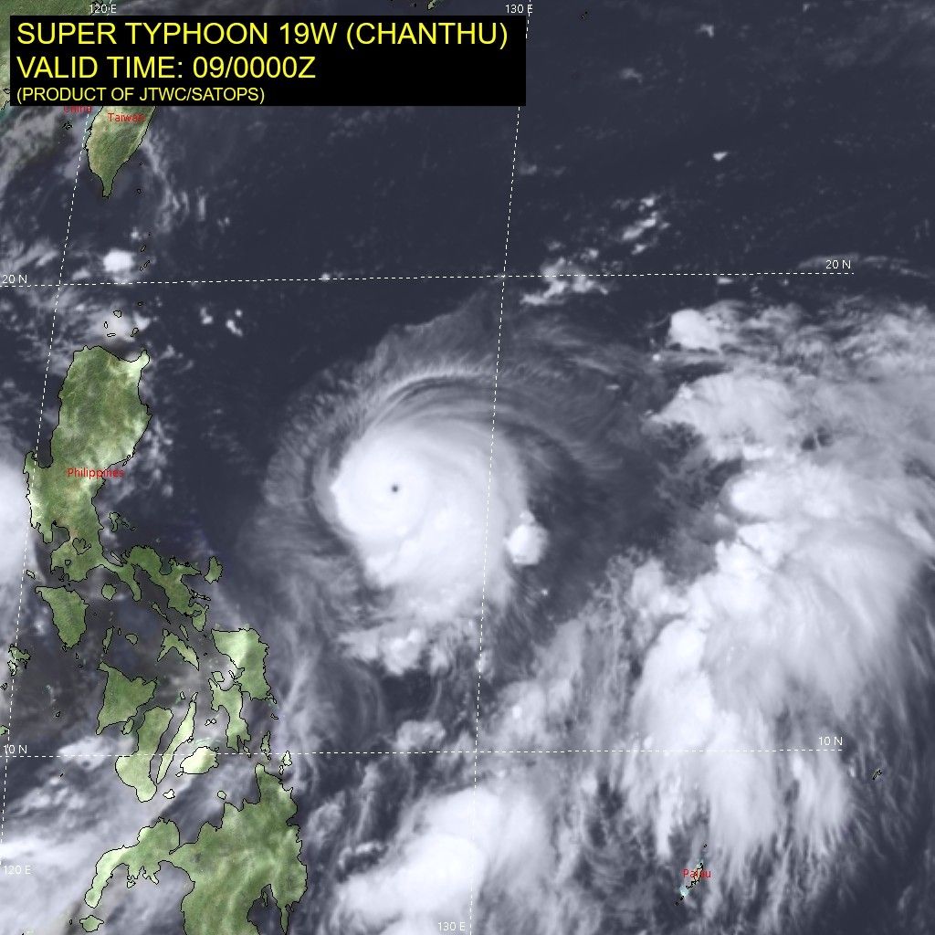
In its latest bulletin, the agency said Kiko (Chanthu) was last seen at 670 kilometers east of Baler in Aurora.
It now has 195 kilometers per hour maximum sustained winds, and gustiness of up to 240 kph.
The storm is moving westward at a speed of 20 kph.
PAGASA said Kiko is seen to continue gaining strength, and could reach peak intensity between 185 to 205 kph tonight or Friday morning.
Tropical Cyclone Wind Signal No. 1 is up over these areas as of 11 a.m. of Thursday:
- Cagayan including Babuyan Islands
- northeastern portion of Apayao (Luna, Pudtol, Flora, Santa Marcela)
- northeastern portion of Isabela (Santa Maria, San Pablo, Maconacon, Divilacan, Palanan)
PAGASA said Cagayan including Babuyan Islands as well as northern Isabela would begin to see heavy to intense with at times torrential rains starting Friday evening.
Batanes and the rest of Isabela, meanwhile, would experience moderate to heavy with at times intense rains.
Weather forecasters are not ruling out the possibility of Kiko making a landfall in Cagayan, given its recent southward shift in its track.
"As such, the public is advised to continue monitoring for possible changes in the track forecast in the succeeding bulletins," PAGASA added.
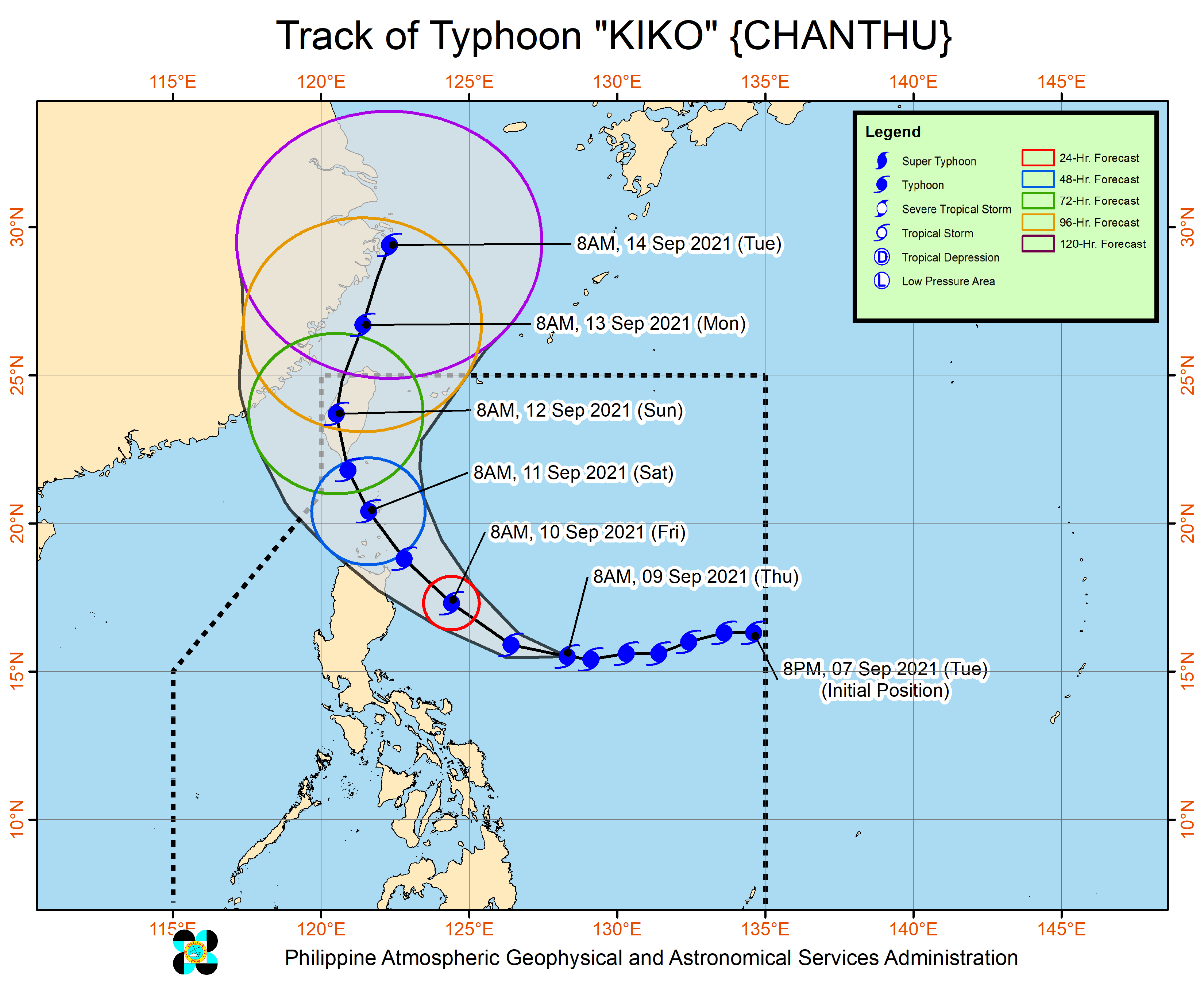
Kiko will move west northwestward in the next 12 hours before it turns northwestward until Saturday.
It is seen to pass very close to northeastern to the south and west of Batanes between morning and afternoon of that day.
Forecast Position
- Friday morning: 285 km east of Tuguegarao City, Cagayan
- Saturday morning: Over the coastal waters of Basco, Batanes
- Sunday morning: 350 km north northwest of Itbayat, Batanes
- Monday morning: 660 km north of Itbayat, Batanes (outside PAR)
'Jolina' out tonight
Tropical Storm Jolina (Conson), meanwhile, continues to move over the West Philippine Sea.
It was last seen at 240 km west of Dagupan City in Pangasinan, carrying 85 kph peak winds and gusts of up to 115 kph.
Jolina threads in a westward direction at a speed of 10 kph.
PAGASA said the storm is expected to make its way out of the Philippine Area of Responsibility later tonight.
Still, said light to moderate with at times heavy rains could be experienced over Palawan, Western Visayas, and Zamboanga Peninsula. — Christian Deiparine
Follow this page for updates on Kiko, the 11th tropical cyclone to enter the Philippines on 2021. — Main photo from JTWC
Typhoon Chanthu unleashed powerful winds and heavy rain on eastern Taiwan Sunday, disrupting travel links and cutting electricity to some homes but sparing the island a direct hit.
Downgraded from a super typhoon since its rapid formation last week, the outer edges of Chanthu pounded the eastern coastline. But the centre of the storm remained out to sea as it moved north, the central weather bureau said.
The eastern regions of Hualien and Taitung have received some 8 inches of rain so far, the bureau added. Waves of up to seven meters were recorded on Orchid Island off Taiwan's eastern coast.
A total of 159 domestic and international flights have been cancelled due to the typhoon, the central emergency operation centre said. All ferry services to offshore islands were also suspended, along with some train routes.
Around 26,000 households have lost power, authorities added. — AFP
PAGASA says Typhoon Kiko has weakened further as it continued to move over the coastal waters of Itbayat, Batanes.
The center of the eye of Typhoon Kiko was spotted over the coastal waters of Itbayat, Batanes. It has maximum sustained winds of 195 kilometers per hour near the center, gustiness of up to 240 kph.
PAGASA says Typhoon Kiko has slightly weakened and is now moving over the coastal waters of Itbayat, Batanes.
PAGASA says Typhoon Kiko made a landfall over Ivana, Batanes at 8:30 a.m. Saturday.
Typhoon Kiko slightly intensifies as it continues to threaten extreme northern Luzon, state weather bureau PAGASA says.
At 10 a.m., the typhoon was located 220 km northeast of Casiguran, Aurora or 220 km east of Tuguegarao City, Cagayan, packing winds of 195 kph and gusts of 240 kph.
Signal No. 3 is still hoisted over parts of Cagayan and Babuyan Islands.


- Latest
- Trending