


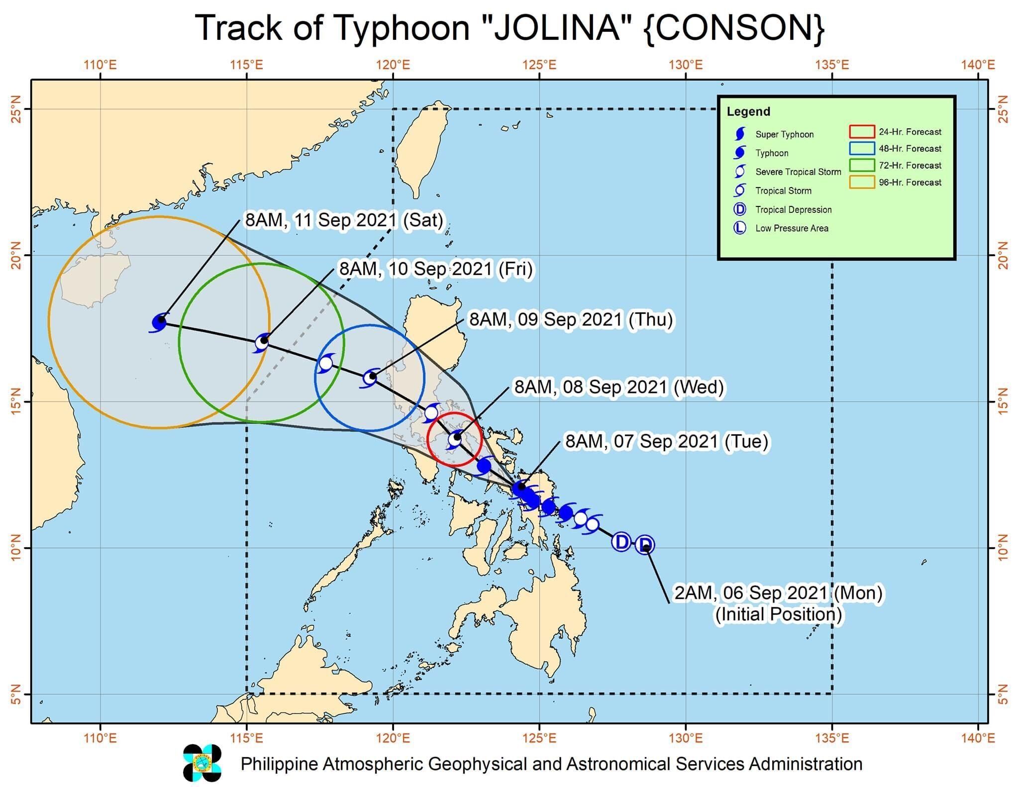
'Jolina' makes 5th landfall in Masbate
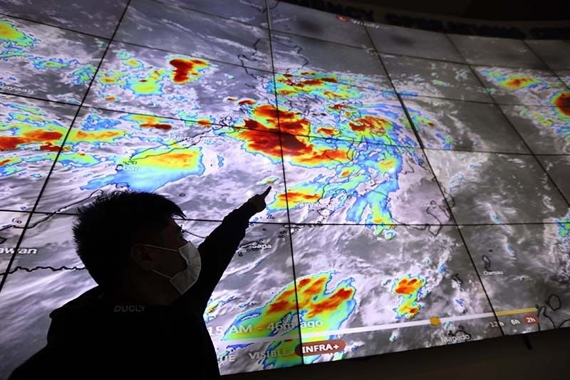
MANILA, Philippines — Typhoon Jolina (Conson) made its fifth landfall in the country over Dimasalang in Masbate as it moves toward the province's mainland, PAGASA said on Tuesday noon.
The agency in its latest bulletin reported Jolina was last seen in the vicinity of the said municipality.
It packs 120 kilometers per hour peak winds and gusts of up to 150 kph when it made a new landfall.
PAGASA said the typhoon now moves west northwestward at a speed of 15 kph.
Jolina has made previous landfalls over Hernani in Eastern Samar, Daram in Samar and Santo Niño in Samar, and Almagro in Samar.
As of 11 a.m. of September 7, these areas remain under the weather bureau's Tropical Cyclone Wind Signals:
TCWS No. 3
(Destructive typhoon-force winds prevailing or expected within 18 hours)
- Extreme southern portion of Quezon (San Francisco, San Narciso, San Andres, Mulanay, Buenavista, Catanauan), Masbate including Ticao and Burias Islands
- western portion of Albay (Pio Duran, City of Ligao, Oas, Libon, Jovellar)
- western portion of Sorsogon (Matnog, Bulan, Magallanes, Pilar, Castilla, Donsol)
- northwestern portion of Samar (Calbayog City, Tagapul-An, Santo Niño, Almagro)
- extreme western portion of Northern Samar (San Antonio, Capul, San Vicente, San Isidro)
- northern portion of Biliran (Maripipi)
TCWS No. 2
(Damaging gale-force to storm-force winds prevailing or expected within 24 hours)
- central and southern portions of Quezon (Real, Mauban, Sampaloc, Lucban, City of Tayabas, Sariaya, Candelaria, Dolores, Tiaong, San Antonio, Lucena City, Pagbilao, Atimonan, Padre Burgos, Agdangan, Unisan, Plaridel, Gumaca, Pitogo,
- Macalelon, General Luna, Lopez, Guinayangan, Calauag, Quezon, Alabat, Perez, Tagkawayan)
- southeastern portion of Batangas (Padre Garcia, Rosario, San Juan, Lobo, Taysan)
- western portion of Camarines Norte (Capalonga, Jose Panganiban, Labo, San Vicente, San Lorenzo Ruiz, Santa Elena)
- western and southern portions
- of Camarines Sur (Del Gallego, Lupi, Ragay, Libmanan, Sipocot, Cabusao, Pasacao, Pamplona, Gainza, Camaligan, Canaman, Magarao, Bombon, Naga City, Pili, Ocampo, Iriga City, Sagñay, Buhi, Milaor, San Fernando, Minalabac, Bula, Nabua, Baao, Balatan, Bato, Calabanga)
- Marinduque
- rest of Albay
- rest of Sorsogon
- eastern portion of Romblon (Cajidiocan, Magdiwang, San Fernando, Romblon, Corcuera, Banton, Concepcion)
TCWS. No 1
(Strong winds prevailing or expected within 36 hours)
- Nueva Ecija
- southeastern portion Nueva Vizcaya (Alfonso Castaneda)
- southern portion of Aurora (Dingalan, San Luis, Maria Aurora, Baler)
- southern portion of Zambales (Masinloc, Palauig, Iba, Botolan, Cabangan, San Felipe, San Marcelino, San Narciso, San Antonio, Castillejos, Subic,
- Olongapo City)
- Bataan
- Tarlac
- Pampanga
- Bulacan
- Metro Manila
- Rizal
- Laguna
- Cavite
- rest of Batangas
- rest of Romblon
- Oriental Mindoro
- northern portion Occidental Mindoro (Abra de Ilog, Paluan, Mamburao, Santa Cruz, Sablayan, Lubang Islands)
- Catanduanes
- rest of Quezon
- rest of Camarines Norte
- rest of Camarines Sur
- Eastern Samar
- rest of Samar
- rest of Northern Samar
- northern portion of Cebu (Daanbantayan, Medellin, Santa Fe, Bantayan Islands, City of Bogo, San Remigio, Tabogon, Borbon, Tabuelan, Sogod, Tuburan, Catmon, Carmen, Danao City, Asturias, Compostela, Camotes Islands, Liloan, Consolacion, Cebu City, Balamban, Mandaue City)
- northern portion Negros Occidental (Cadiz City, Manapla, Enrique B. Magalona, City of Victorias, Sagay City, City of Escalante, Toboso, Calatrava, Silay City)
- northern portion of Iloilo (Carles, Estancia, Balasan, Batad, San Dionisio, Concepcion, Sara, Ajuy, Lemery, San Rafael, Barotac Viejo, City of Passi, Bingawan)
- Capiz
- Aklan
What to expect
PAGASA said Jolina will bring heavy to intense with at times torrential rains over Masbate, Biliran, Samar, Northern Samar, Sorsogon, Albay, Catanduanes, Camarines provinces, as well as Southern Quezon, Romblon and Marinduque.
Heavy and at times intense rains, meanwhile, would be experienced in Mindoro provinces and rest of Calabarzon and Visayas.
"Under these conditions, scattered to widespread flooding (including flash floods) and rain-induced landslides are possible," the agency said, "especially in areas that are highly or very highly susceptible to these hazard as identified in hazard maps."
Weather forecasters added there is a threat of coastal inundation due to storm sruge of up to 0.5 to 1.0 meter for several coastal localities of Biliran, Sorsogon, Samar and Masbate.
PAGASA said, too, that coastal areas of localities under its tropical cyclone wind signals could see coastal flooding due to hazardous surf conditions.
Jolina is seen to keep moving generally west northwestward in the next 12 hours, moving toward Masbate and Ragay Gulf.
It is forecast to make another landfall in the vicinity of southeastern Quezon tonight or early Wednesday morning.
Forecast position
- Wednesday morning: In the vinicity of Tanay, Rizal
- Thursday morning: 100 km west northwest of Iba, Zambales
- Friday morning: 550 km west of Baguio City, Benguet (outside PAR)


- Latest
- Trending


