Signal No. 3 up over Metro Manila, 12 other areas as Rolly heads toward Batangas, Cavite
MANILA, Philippines (Update 2, 6:15 p.m.) — Bringing devastating winds and fierce rainfall, Typhoon Rolly (international name: Goni) is roaring toward the provinces of Batangas and Cavite, state weather bureau PAGASA said late Sunday afternoon.
The strongest storm of the year was last located 50 kilometers south southwest of Tayabas in Quezon province bearing sustained winds of 165 kphour near the center and gusts of up to 230 kph. It is moving west at 25 kph.
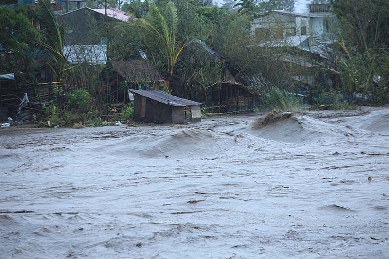
Rolly was downgraded from a super typhoon as it crossed the southern end of Luzon, ripping off roofs, tipping electric posts and trees, and triggering flash floods and landslides. Although it continues to weaken as it traverses Southern Luzon, Rolly remains powerful.
Between 19 and 31 million Filipinos are projected to be affected by Rolly. Around 19.8 million are also seen to be directly exposed to the typhoon, including in areas previously battered by Typhoon Quinta (international name: Molave).
At least four people have been reportedly killed.
The center of the typhoon will head toward Batangas-Cavite area from late afternoon to evening. The center of Rolly’s eye is forecast around 70 km south of Metro Manila between 5 to 7 p.m.
PAGASA said “destructive winds and intense rainfall” are prevailing or expected within 12 hours over Batangas and Cavite. “This is a particularly dangerous situation for these areas,” it warned.
Currently, there are no more areas under Tropical Cyclone Wind Signal No. 4. Here are the areas remaining under tropical cyclone wind signals:
Signal No. 3 (destructive typhoon-force winds)
- Southern portion of Zambales (San Marcelino, San Narciso, Subic, Olongapo City, Castillejos, San Antonio)
- Bataan
- Southern portion of Pampanga (Floridablanca, Guagua, Minalin, Apalit, Macabebe, Masantol, Sasmuan, Lubao)
- Southern portion of Bulacan (Baliuag, Bustos, Angat, Norzagaray, San Jose del Monte City, Santa Maria, Pandi, Plaridel, Pulilan, Calumpit, Malolos City, Guiguinto, Balagtas, Bocaue, Marilao, Meycauayan City, Obando, Bulacan, Paombong, Hagonoy)
- Rizal
- Quezon including Polillo Islands
- Metro Manila
- Cavite
- Laguna
- Batangas
- Marinduque
- Northwestern portion of Occidental Mindoro (Santa Cruz, Mamburao, Paluan, Abra de Ilog) including Lubang Island
- Northern portion of Oriental Mindoro (Puerto Galera, San Teodoro, Baco, Calapan City, Naujan, Victoria, Naujan Lake, Pola, Socorro)
Signal No. 2 (damaging gale- to storm-force winds)
- Rest of Zambales
- Rest of Pampanga
- Rest of Bulacan
- Southern portion of Tarlac (Concepcion, Capas, Bamban)
- Rest of Occidental Mindoro
- Rest of Oriental Mindoro
- Southern portion of Nueva Ecija (General Tinio, Gapan City, Peñaranda, San Leonardo, Jaen, San Isidro, Cabiao, San Antonio)
Signal No. 1 (strong breeze to near gale conditions)
- Mainland Cagayan
- Isabela
- Apayao
- Kalinga
- Mountain Province
- Ifugao
- Abra
- Ilocos Norte
- Ilocos Sur
- La Union
- Benguet
- Nueva Vizcaya
- Quirino
- Rest of Aurora
- Rest of Nueva Ecija
- Rest of Tarlac
- Camarines Sur
- Camarines Norte
- Burias Island
- Romblon
- Calamian Islands
Rainfall, storm surge warnings
Typhoon Rolly will also bring heavy to at times intense rains over CALABARZON, Metro Manila, Marinduque, Romblon, Mindoro provinces, Bataan, Bulacan, Aurora, eastern portions of mainland Cagayan and Isabela.
Moderate to heavy rains will affect Cordillera Administrative Region and the rest of mainland Cagayan Valley and Central Luzon, while light to moderate with at times heavy rains will prevail over Zamboanga Peninsula, Bangsamoro, Western Visayas and the rest of Luzon.
PAGASA warned that flooding, rain-induced landslides and lahar flows may occur during heavy or prolonged rainfall.
The state weather bureau also warned there is “high risk” of storm surge of up to three meters over the northern coastal areas of Quezon province, including Polillo Islands, coastal areas of Metro Manila, Cavite, Bulacan, Pampanga, Bataan, the southeastern coastal areas of Batangas, and most of the southern coastal areas of Quezon province in the next 24 hours.
A storm surge of up to two meters could also happen in the coastal areas of Marinduque, Lubang Island, Albay, Masbate (including Ticao and Burias Islands), northern coastal area of Mindoro provinces and the remaining coastal areas of Quezon and Batangas.
There is also a moderate to high risk of seiche (oscillations of a landlocked body of water) or storm surge over the coastal areas surrounding Laguna de Bay and Taal Lake.
“These storm surges, which may be accompanied by swells and breaking waves reaching the coast can cause life-threatening and damaging coastal inundation,” PAGASA said.
Sea travel is risky for all types of seacrafts over the seaboards of areas under wind signals due to rough to phenomenal seas and the remaining seaboards of Northern Luzon and the eastern seaboards of Eastern Visayas due to rough to very rough seas.
Meanwhile, moderate to rough seas will be experienced over remaining seaboards of the country.
Rolly is expected to leave the landmass of mainland Luzon and emerge over the West Philippine Sea Sunday evening. It may weaken as it passes Southern Luzon but will become a typhoon over the West Philippine Sea.
The typhoon comes a week after Quinta struck the same area and killed at least 22 people.
The Philippines, an archipelagic country prone to disasters, is affected by an average of 20 tropical cyclones annually.
Forecast positions
- Monday afternoon: 300 km west of Iba, Zambales
- Tuesday afternoon: 665 km west of Iba, Zambales (outside PAR)
- Wednesday afternoon: 935 km west of Central Luzon (outside PAR)
— Franco Luna and Gaea Katreena Cabico


- Latest
- Trending