


'Ambo' maintains strength, barrels toward Bulacan
MANILA, Philippines (Update 1, 9:45 p.m.) — Severe Tropical Storm Ambo (international name: Vongfong) maintained its strength on Friday evening as it barrels toward Bulacan, the state weather bureau said.
At 7:00 p.m. today, "Ambo" was last seen in the vicinity of General Nakar, Quezon, with peak winds of 100 kilometers per hour near the center and gusts of up to 165 kph. It is heading northwest at 20 kph.
Based on the 8 p.m. weather bulletin, the severe tropical storm has made landfall in Real, Quezon at 5 p.m. Friday.
"Ambo" made seven landfalls between Thursday afternoon and Friday evening: San Policarpio in Eastern Samar, Dalupiri Island and Capul Island in Northern Samar, Ticao Island and Burias Island in Masbate, San Andres in Quezon and Real in Quezon.
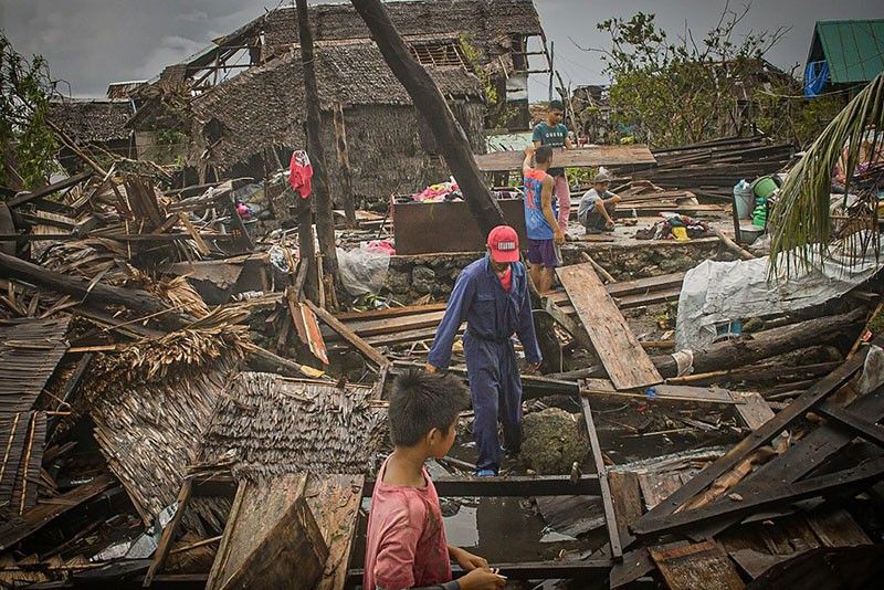
The tropical cyclone—the first to hit the Philippines this year—forced tens of tens of thousands to flee their homes at a time when the country is put under lockdown, complicating the government’s response to the growing threat of the novel coronavirus.
PAGASA hoisted tropical cyclone wind signals over the following areas:
TCWS No. 2 (Winds between 61 kph and 120 kph in at least 24 hours)
- Ilocos Norte
- Ilocos Sur
- Apayao
- Abra
- Kalinga
- Mountain Province
- Ifugao
- Benguet
- La Union
- Nueva Vizcaya
- Nueva Ecija
- Quirino
- Aurora
- eastern portion of Pangasinan (San Nicolas, Natividad, San Quintin, Umingan, Balungao, Sta. Maria, Tayug, Asingan, San Manuel, Binalonan, Laoac, Urdaneta, Villasis, Rosales, Sto. Tomas, Alcala, Bautista, Bayambang, Urbiztondo, Basista, Malasiqui, Sta. Barbara, Manaoag, Mapandan, San Jacinto, San Fabian, Pozorrubio, Sison, Mangaldan, Dagupan, Calasiao, Binmaley, Lingayen, Bugallon, Aguilar, San Carlos, Mangatarem)
- Tarlac
- Pampanga
- Bulacan
- Metro Manila
- Cavite
- Laguna
- Rizal
- northern and central portion Quezon (General Nakar, Infanta, Real, Mauban, Sampaloc. Lucban, Tayabas, Sariaya, Candelaria, Dolores, Tiaong, San Antonio, Lucena, Pagbilao, Atimonan, Padre Burgos, Agdangan, Plaridel, Unisan, Gumaca, Pitogo, Macallelon, General Luna, Catanauan, Lopez, Buenavista, Guinayangan, Calauag, Tagkayawan, Perez, Alabat, Quezon)
- Polillo Islands
- southern and western portion of Isabela (Quezon, Mallig, Roxas, Quirino, San Manuel, Burgos, Gamu, Reina Mercedes, Aurora, Luna Cabatuan, Naguilian, Benito Soliven, Cauayan, San Guillermo, Dinapigue, San Mateo, Alicia, Angadanan, Ramon, San Isidro, Echague, Jones, San Agustin, Santiago, Cordon)
TCWS No. 1 (Winds between 30 kph and 60 kph in at least 36 hours)
- Cagayan including Babuyan Islands
- Batanes
- Zambales
- Bataan
- rest of Isabela, Batangas, Marinduque, the rest of Quezon, Camarines Norte, and the northwestern portion of Camarines Sur (Del Gallego, Ragay, Lupi, Sipocot)
Rainfall outlook
Weather forecasters said moderate to heavy with at times intense rains will be experienced over Metro Manila, CALABARZON, Aurora, Bulacan, Pampanga, Nueva Ecija, Isabela, Nueva Vizcaya, Quirino, Occidental Mindoro and Marinduque.
Between tonight and Saturday, residents of Cordillera Administrative Region, Ilocos Region, Central Luzon, Nueva Vizcaya and Quirino will have moderate to heavy with at times intense rains.
PAGASA warned that flooding and rain-induced landslide may happen in highly to very highly susceptible areas during heavy or prolonged rainfall.
It added that risky for all types of sea vessels over the seaboards of areas under TCWS.
Forecast positions
- 24 hour (Saturday afternoon): 85 km northwest of Laoag City, Ilocos Norte
- 48 hour (Sunday afternoon): 85 km north of Basco, Batanes
- 72 hour (Monday afternoon): 740 km northeast of Basco, Batanes (outside PAR)
- 96 hour (Tuesday afternoon): 2,380 km northeast of Basco, Batanes (outside PAR)


- Latest
- Trending


