Are the seas around Pag-asa international waters?
MANILA, Philippines —Commenting on the presence of Chinese ships near a Philippine-occupied feature in the West Philippine Sea, pro-Duterte blogger Sass Rogando Sasot argued in a series of social media posts on Tuesday that waters around Pag-asa island in the Spratlys “remain international waters.”
“As long as the sovereignty issue over the Spratlys hasn't been resolved, those waters remain international waters,” Sasot wrote on her Facebook page, which has almost 700,000 followers.
“Are the waters around Pag-Asa Island ‘traditional fishing grounds’ of coastal states of South China Sea? YES, just like the waters of Scarborough Shoal,” she added.
The Philippine military has confirmed that hundreds of Chinese ships have been loitering near Pag-asa, also known as Thitu Island.
In a rare rebuke, President Rodrigo Duterte earlier warned China to "lay off" of Pag-asa Island, one of the largest features in the Spratly chain, or he will send his troops on a "suicide mission.”
RELATED: DFA: Chinese vessels near Pag-asa Island illegal
UNCLOS
In an April 8 commentary posted on Facebook, Jay Batongbacal, director of the University of the Philippines Institute for Maritime Affairs and Law of the Sea, explained that under Section 2 of Republic Act 9522, the maritime zones of the Kalayaan Island Group will be determined in accordance with Article 121 of the United Nations Convention on the Law of the Sea.
Article 21 of UNCLOS states that “[t]he territorial sea, the contiguous zone, the exclusive economic zone and the continental shelf of an island are determined in accordance with the provisions of this Convention applicable to other land territory.”
UNCLOS also said “rocks which cannot sustain human habitation or economic life of their own shall have no exclusive economic zone or continental shelf.”
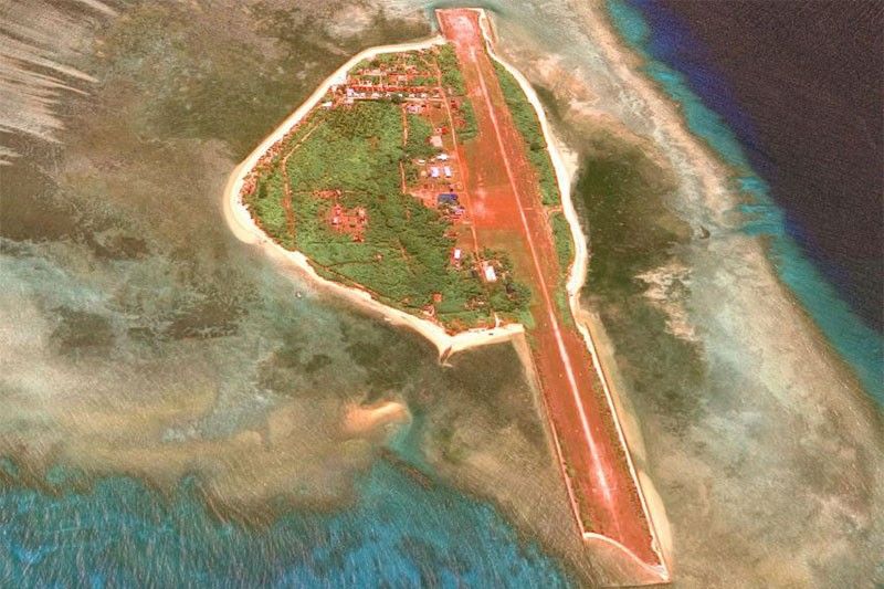
The municipality of Kalayaan in Palawan province has jurisdiction over Pag-asa Island — the largest of the nine features occupied by the Philippines in the Spratlys Islands and is home to about 100 civilians along with a small military garrison. The Philippines is currently repairing and upgrading its facilities, particularly its porous runway, on the island.
When RA 9522 was still a bill, Batongbacal said “the House version which would have allowed them (Pag-asa Island and the Kalayaan Island Group) to generate [exclusive economic zone/continental shelf] was dropped.”
“This was done specifically to enable the Philippines to not have the islands entitled to a EEZ/CS of their own, in order for the law to be less provocative to China and to protect the integrity of the main archipelago's baselines,” he said.
“[Attorney] Estelito Mendoza, who coordinated between the Executive and the Senate, believed that this strategy was the best way to keep the baselines of the main archipelago from being subjected to diplomatic protest and never being accepted, and allow room for negotiation over the disputes,” he added.
RA 9522 also holds that:
The baseline in the following areas over which the Philippines likewise exercises sovereignty and jurisdiction shall be determined as "Regime of Islands" under the Republic of the Philippines consistent with Article 121 of the United Nations Convention on the Law of the Sea (UNCLOS):
a) The Kalayaan Island Group as constituted under Presidential Decree No. 1596; and
b) Bajo de Masinloc, also known as Scarborough Shoal.
Sen. Miriam Defensor-Santiago, in her sponsorship speech of the Senate version of the Baselines bill in 2009 explained that "under the 'regime of islands,' each island has its own territorial sea, contiguous zone, EEZ, and continental shelf."
"We are constrained to observe the 'regime of islands' principle with respect to the Spratlys, because it is a flashpoint in Asia, subject to conflicting territorial claims by several Asian countries," she said.
‘Not international waters’
On the reported presence of Chinese ships near Pag-asa Island, Batongbacal said that “for the Chinese vessels to be in international waters, they'd have to be already inside their base on Subi Reef, which was originally a low tide elevation without maritime zones, around 15 [nautical miles] away.”
“So there can be no doubt that all sighted vessels were located within the 12 nm territorial sea of Pag-asa, not international waters,” Batongbacal added.
Earlier this year, Washington-based think tank Asia Maritime Transparency Initiative (AMTI) released satellite photos showing People's Liberation Army Navy, Chinese Coast Guard ships and fishing vessels near Chinese-occupied Subi Reef, which is 12 nautical miles from Pag-asa Island.
The Chinese vessels have been operating in the area around the same time the Philippines started repairs on Pag-asa Island as early as July 2018.
Subi was a low-tide elevation before China built an artificial island on it. As such, it does not generate its own territorial sea but could bump out the territorial sea of at least one of the unoccupied sand cays, which is dry at high tide and located less than 12 nautical miles from it, the AMTI explained.
In a 2017 report, AMTI said: “Setting aside whether Chinese ships legally can fish within 1 nautical mile of Thitu Island, there is no doubt that doing so is highly provocative and runs counter to the narrative of a stable mutually-beneficial new status quo that Beijing has sought to project.” — Ian Nicolas Cigaral with reports from Patricia Lourdes Viray


- Latest
- Trending