'Marce' strengthens as it tracks to Surigao
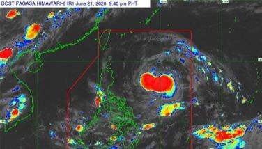
MANILA, Philippines (First published 9:45 a.m.) — Tropical Depression Marce is expected to make landfall over Surigao province on Thursday afternoon or early evening as it moves closer to Mindanao, state weather bureau PAGASA said.
As of 1 p.m. on Thursday, Marce was located at 105 kilometers east northeast of Hinatuan, Surigao del Sur.
In an advisory, PAGASA said the cyclone accelerated as it continues to move northwest at 19 kilometers per hour (kph) with maximum sustained winds of 45 kph near the center, and gustiness of up to 55 kph.
PAGASA hoisted warning signals over the following areas:
Signal No. 1 (winds of 30 to 60 kilometers per hour in 36 hours)
Luzon: Romblon and Cuyo Island
Visayas: Biliran, Southern part of Samar, Southern part of eastern Samar, Leyte, Southern Leyte, Bohol, Cebu including Bantayan and Camotes Islands, Siquijor, Negros Oriental, Negros Occidental, Iloilo, Capiz, Aklan, Antique and Guimaras
Mindanao: Surigao del Norte including Siargao Island, Surigao del Sur, Dinagat Islands, Agusan del Norte, Agusan del Sur, Misamis Oriental and Camiguin.
Those under the tropical cyclone signal number 1 and the rest of eastern Visayas are also advised to be alert for possible flash floods and landslides.
It is expected to exit the Philippine area of responsibility on Monday morning.
Rainfall is estimated to be from moderate to heavy within the 300 km diameter of the tropical depression.
Caraga, Central Visayas, Negros Island Region and the provinces of Misamis Oriental, Camiguin and Southern Leyte will experience rains and gusty winds, while Davao Region, rest of Eastern Visayas and Northern Mindanao will experience cloudy skies with moderate to occasionally heavy rains and thunderstorms which may lead to possible flash floods and landslides.
Cloudy skies with light to moderate rains and thunderstorms will be experienced over Bicol Region, Palawan, and the rest of Visayas and of Mindanao.
Forecast track of Tropical Depression Marce as of Thursday morning, according to PAGASA.
Meanwhile, the rest of Luzon and Metro Manila will experience partly cloudy to cloudy skies with isolated rain showers and thunderstorms.
The public is reminded that sea travel is risky over the northern seaboard of Northern Luzon, with waves reaching 1.25 to 4 meters in height in the open seas.


- Latest
- Trending