


RollyPH
Australia provides an additional P28.52 million to support Filipino communities affected by tropical cyclone Rolly in the Bicol Region.
This will help the government provide food, repair damaged homes and support emergency medical teams in the region. Australia's latest commitment will directly assist 23,345 people, including 2,990 women and girls.
"This support is even more critical following Typhoon Ulysses that caused further hardship for the people in the Bicol Region. Australia stands with the Philippines in this time of need," Australian Ambassador Steven Robinson says.
President Rodrigo Duterte may place the regions of CALABARZON, MIMAROPA, and Bicol under state of calamity because of the impact of typhoon "Rolly," Malacañang says.
The National Disaster Risk Reduction and Management Council has approved a recommendation to place the three Luzon regions under state of calamity to fast-track the recovery of the typhoon-ravaged areas.
"Most likely, but let us wait for the document that will come from the Office of the President," presidential spokesman Harry Roque said at a press briefing when asked if Duterte would adopt the recommendation of the council. — Alexis Romero
The provincial board has placed Camarines Sur under state of calamity following the onslaught of Typhoon Rolly.
In a resolution released Monday, the local government cited strong winds and torrential rains, as well as the extensive flooding and other damages brought about by the typhoon.
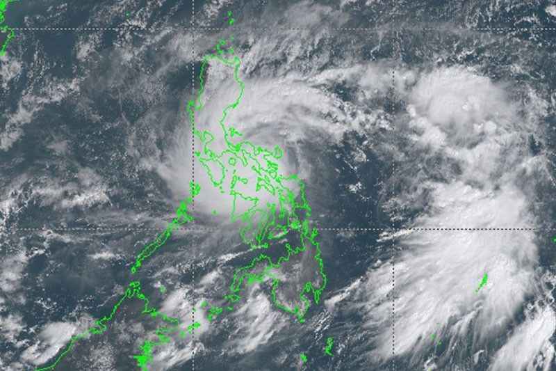
At 3 p.m., Tropical Storm Rolly was located 225 kilometers west of Iba, Zambales.
The cyclone bears maximum sustained winds of 65 kph and gusts of up to 80 kph. It is moving north northwestward at 15 kph.
Vice President Leni Robredo posts photos of the first signs of devastation brought about by Typhoon Rolly in Camarines Sur.
Robredo says she left Manila before dawn on Monday to visit the typhoon-hit province.
The vice president will also be visiting Albay and Catanduanes.
Left Manila before dawn today. Just arrived CamSur and these were the first signs of devastation we saw. Will be going around Albay and Catanduanes, as well.
Posted by Leni Gerona Robredo on Sunday, 1 November 2020
Two helicopters of the Philippine Coast guard have been deployed in Catanduanes to conduct damage assessment and emergency response operations.
The coast guard also deployed its BN Islander plane to identify hotspots in the province where immediate rescue and relief missions are needed.
"Let us be God's instrument in helping the people of Catanduanes," PCG Commandant Adm. George Ursabia says.
ATM: The Philippine Coast Guard (PCG) deploys airbus light twin engine helicopters with tail numbers CGH-1451 and...
Posted by Philippine Coast Guard on Sunday, 1 November 2020
"It’s confirmed that President Duterte will be flying from Davao to Manila today," presidential spokesperson Harry Roque tells reporters.
"En route to Manila, he will be conducting an aerial inspection in Bicolandia and Calabarzon," he added. — Report by Alexis Romero
Cyclone Rolly, now a tropical storm, is expected to leave the Philippine area of responsibility on Tuesday morning, state weather bureau PAGASA says at a midday briefing.
On its way out, it is expected to weaken further from a storm to a tropical depression.
Tropical Storm Rolly was 100 km west southwest of Subic Bay early Monday morning and is moving west northwest at 20 km/h.
The storm, which has maximum sustained winds of 65 km/h near the center and gustiness of up to 80 km/h.
"On the forecast track, 'ROLLY' is expected to exit the Philippine Area of Responsibility (PAR) tomorrow morning," PAGASA says. "It is forecast to remain as a tropical storm throughout the forecast period."
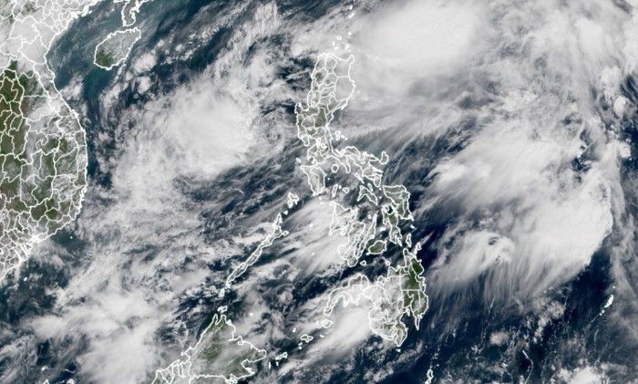
Typhoon Rolly continues to move towards the Batangas-Cavite area. It is expected to be around 70 km south of Metro Manila between 5 p.m. and 7 p.m.
Rolly is forecast to exit mainland Luzon and emerge over the West Philippine Sea Sunday night.
At 4 p.m., the tropical cyclone was located 50 km south southwest of Tayabas, Quezon, bearing maximum winds of 165 kph and gustiness of 230 kph. It is moving westward at 25 kph.
The province of Cavite has been placed under a state of calamity following the onslaught of Typhoon Rolly.
"Ang lahat ay pinapaalalahanang maging ligtas. Kung kinakailangan ay lumisan na sa tirahan at makipag ugnayan sa inyong lokal na pamahalaan," DILG Cavite said in a Facebook post.
BASAHIN ???? Idineklara na ang State of Calamity sa buong Lalawigan ng Cavite dahil sa posibleng epektong dulot ng bagyong...
Posted by DILG Cavite on Saturday, 31 October 2020
Typhoon Rolly makes its third landfall over San Narciso, Quezon as it further weakens Sunday afternoon.
State weather bureau PAGASA says the center of the typhoon will continue to move over the Marinduque-Central Quezon area Sunday afternoon and towards Batangas-Cavite area late Sunday afternoon through evening.
At 1 p.m., Rolly was located over the coastal waters of Mulanay, Quezon with maximum winds of 175 kph and gusts of 240 kph. It is moving westward at 25 kph.
As of 12 p.m. on Sunday, the Philippine Coast Guard has recorded a total of 1,960 passengers, truck drivers, and cargo helpers; 83 vessels; 119 motorbancas; and 846 rolling cargoes in Bicol, Southern Tagalog, NCR, and Eastern Visayas due to Typhoon Rolly.
A total of 196 vessels and 45 motorbancas are also taking shelter as a precaution against the onslaught of the tropical cyclone.
"The PCG Command Center is on 24/7 monitoring to strictly implement guidelines on the movement of vessels during heavy weather," the coast guard says.
Rolly has weakened into a typhoon as it moves towards the Marinduque-Southern Quezon area. It will then pass over the Batangas-Cavite area late Sunday afternoon through evening.
At 10 a.m., Rolly was located over the coastal waters of Pasacao, Camarines Sur or 30 km west Southwest of Pili, Camarines Sur with maximum sustained winds of 215 kph near the center and gustiness of up to 295 kph.
"'Rolly' is forecast to exit the mainland Luzon landmass and emerge over the Philippine Sea between tonight and tomorrow early morning,' state weather bureau PAGASA says.
Albay Gov. Al Francis Bichara confirms that two casualties have been reported so far in the province following the landfall of Super Typhoon Rolly Sunday morning.
Rolly made its second landfall over Tiwi, Albay at around 7:20 a.m.
The Philippine National Railways on Sunday also temporarily suspends its operations due to the severe weather condition brought about by the typhoon.
PNR General Manager Junn Magno says the train leaving Tutuban station at 10:06 a.m. will be the sweeper train that will ferry all remaining passengers and personnel.
"Bicol Commuter Train already suspended effective opening of business hours.
Operation, Engineering, RSM and Security Personnel are hereby placed on high-alert status," Magno says.
The Department of Transportation suspends the operations of LRT-1, LRT-2 and MRT-3 after PAGASA placed Metro Manila under Signal No. 4.
The Philippine National Railways is also preparing for suspension of operations, DOTR says.
"Passengers and employees who are already on trains and stations will be ferried to their destinations," the agency says Sunday morning.
Super Typhoon Rolly has made its second landfall over Tiwi, Albay at around 7:20 a.m. as it continues to bring catastrophic violent winds and intense to torrential rainfall over the Bicol region.
State weather bureau PAGASA says Rolly will cross the Camarines provinces before heading towards Marinduque-Southern Quezon Sunday afternoon.
At 7 a.m., the super typhoon was located in the vicinity of Tiwi, Albay with maximum sustained winds of 225 kph and gusts of up to 310 kph. It is moving westward at 25 kph.
PAGASA says "Rolly" has intensified into a super typhoon and made its first landfall over Bato Catanduanes.
As of 4:50 a.m.,super typhoon "Rolly" was located based on all available including those from Virac, Daet, and Guiuan Doppl In the vicinity of Bato, Catanduanes.
It has maximum sustained winds of 225 kilometers per hour, near the center and gustiness of up to 280 kph.
Signal No. 4 was raised over Catanduanes and eastern portion of Camarines Sur as Typhoon Rolly maintains its strength.
In its 8 a.m. weather bulletin, "Rolly" was located 280 kilometers east northeast of Virac, Catanduanes.
It has maximum sustained winds of 215 kilometers per hour near the center and gustiness of up to 265 kph.
PAGASA says Typhoon Rolly continues to move towards Bicol Region while maintaining its strength.
"Rolly" has maximum sustained winds of 215 kilometers per hour near the center and gustiness of up to 265 kph.
In its 5 p.m. advisory, PAGASA says that the eye of "Rolly" was spotted 345 kilometers east northeast of Virac, Catanduanes.
More areas in Bicol Region have been placed under Signal No. 3 as Typhoon Rolly keeps strength.
As of 1:00 p.m. Saturday, "Rolly" was located at 410 kilometers east northeast of Virac, Catanduanes.
The typhoon has maximum sustained winds of 215 kilometers per hour near the center and gustiness of up to 265 kph.
Signal No. 3 has been raised in Catanduanes after PAGASA says Typhoon Rolly has maintained its strength as it moves west-southwest towards Bicol Region.
As of 10 a.m., the eye of "Rolly" was spotted at 480 kilometes east northeast of Virac, Catanduanes.
It has maximum sustained winds of 215 kilometers per hour near the center and gustiness of up to 265 kph.
PAGASA reports that Typhoon Rolly has continued to move west-southwestward over the Philippine Sea as it maintains its strength.
In its 8 a.m. bulletin, "Rolly" was located at 540 kilometers east northeast of Virac, Catanduanes.
"Rolly" has maximum sustained winds of 215 kilometers per hour near the center and gustiness of up to 265 kph.
PAGASA says Typhoon Rolly has maintained its strength while moving closer to Bicol Region.
As of 4 a.m. Saturday, "Rolly" was spotted 655 kilometers northeast of Virac, Catanduanes. Moving west at 20 kilometers per hour, it has maximum sustained winds of 215 kph near the center and gustiness of up to 265 kph.
Signal No. 2 are hoisted over the following areas: Catanduanes, the eastern portion of Camarines Sur (Caramoan, Garchitorena, Lagonoy, Tinambac, Siruma, Presentacion, San Jose, Goa, Buhi, Sagnay, Tigaon, Ocampo, Iriga City, Baao, Nabua, Bato, Balatan, Bula, Pili, Calabanga, Naga City, Bombon, Magarao, Canaman, Gainza, Milaor, Camaligan, Minalabac), Albay and Sorsogon.
PAGASA says Typhoon Rolly has intensified further as it moves westward over the Philippine Sea.
As of 4 p.m. Friday, the typhoon was 980 kilometers east of east of Casiguran, Aurora and has maximum sustained winds of 185 kilometers per hour near the center and gustiness of up to 230 kph.
"The center of the eye of 'ROLLY' is likely to make landfall over the Aurora-Quezon area on Sunday evening or Monday early morning," the state bureau says.
'Rolly' has slowed as it moves west at 15 km/h but has also gathered strength, according to PAGASA's 11 a.m. update.
As of 10 a.m., the typhoon was 1,100 km east of Central Luzon and has maximum sustained winds of 165 km/h near the center and gustiness of up to 205 km/h.
'Rolly' is forecast move west-southwestward until Saturday evening before moving west-northwest over the sea off the Bicol Region. PAGASA says the typhoon will likely make landfall over the Aurora-Quezon area on Sunday evening or early Monday morning.
"The typhoon is forecast to continuously intensify over the Philippine Sea and is likely to make landfall at peak intensity of 175-185 km/h," PAGASA also says.
Severe Tropical Storm Rolly was 1,195 kilometers east of Central Luzon on Friday morning and moving west at 20 km/h.
PAGASA weather forecaster Ezra Bulquerin says on TeleRadyo that 'Rolly' has winds of 140 km/h near the center and gustiness of up to 170 km/h.
The storm has already started affecting the Bicol Region, the Visayas, Northern Mindanao, and Caraga.
Bulquerin says skies will be cloudy in those areas and some rain is expected.
'Rolly' is forecast to make landfall between Sunday evening and Monday morning.
PAGASA is also monitoring a tropical storm 2,430 kilometers east of Mindanao that is still outside the Philippine Area of Responsibility.
Moving north at 20 km/h, that storm has winds of 55 km/h near the center and gustiness of up to 80 km/h.
PAGASA says severe tropical storm Goni entered the Philippine Area of Responsibility. It was given the local name "Rolly".
"Severe Weather Bulletins will be issued starting at 11:00 PM," it adds.
Follow this thread for updates on tropical cyclone Rolly (international name: Goni).


- Latest
- Trending


