


Super Typhoon Henry intensifies slightly
MANILA, Philippines — Super Typhoon Henry (Hinnamnor) has intensified slightly and is expected to strengthen further ahead of its slowdown, state weather bureau PAGASA said Thursday.
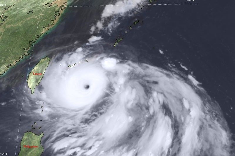
Henry was last seen 430 kilometers east northeast of Itbayat, Batanes with peak winds of 195 kph near the center and gusts of up to 240 kph.
It is heading south southwest northeast of Batanes at 25 kph.
Meanwhile, Tropical Depression Gardo weakened into a remnant low, which will likely be absorbed within the circulation of Henry.
What to expect
Henry is expected to dump light to moderate with at times heavy rains over Batanes. By Friday, moderate to heavy rains may affect Batanes and Babuyan Islands.
The super typhoon is also forecast to enhance the southwest monsoon, which may bring rains over the western section of Luzon starting Friday.
“Posible na magtaas tayo ng signal dito sa Batanes area ngayong araw at hindi natin niru-rule out ‘yung Signal No. 2 pa rin. Worst case scenario tulad ng nabanggit kahapon hanggang Signal No. 3 pero magdedepende ito sa pagbaba, pagsubsob mismo ng track ni Henry,” PAGASA senior weather specialist Raymond Ordinario said.
(We might raise storm signals over the Batanes area today and we're not ruling out raising Signal No. 2. As we mentioned yesterday, our worst-case scenario is Signal No. 3, but that will depend on Henry's track)
PAGASA issued a gale warning for the northern and eastern seaboards of northern Luzon as Henry affects weather there.
In the next 24 hours, the super typhoon may bring moderate to rough seas over the eastern seaboard of Isabela. Such conditions may pose risks to those using small seacrafts.
Henry is forecast to continue moving generally south southwestward until early Friday morning while decelerating. It may “become almost stationary” by Wednesday evening or early Friday morning.
“This super typhoon is forecast to further intensify during the remaining time window before it enters its slowdown or quasi-stationary phase, when it is likely to begin weakening. Once it begins accelerating northward during the weekend, a slight re-intensification may still occur,” PAGASA said.
Henry is expected to leave the Philippine Area of Responsibility on Saturday evening or Sunday morning.
Henry’s track
- 8 p.m., September 1: 375 km east northeast of Basco, Batanes
- 8 a.m., September 2: 370 km east northeast of Basco, Batanes
- 8 p.m., September 2: 355 km east northeast of Itbayat, Batanes
- 8 a.m., September 3: 380 km northeast of Itbayat, Batanes
- 8 p.m., September 3: 475 km northeast of Itbayat, Batanes
- 8 a.m., September 4: 630 km north northeast of Itbayat, Batanes (outside PAR)
- 8 a.m., September 5: 996 km north northeast of Extreme Northern Luzon (outside PAR)
— Gaea Katreena Cabico


- Latest
- Trending


