Super typhoon Henry to absorb Gardo in the next hours — PAGASA
MANILA, Philippines — State weather bureau PAGASA said Tropical Depression Gardo is expected to weaken into a low pressure area and be absorbed by the stronger super typhoon Henr (international name: hinnamnor).
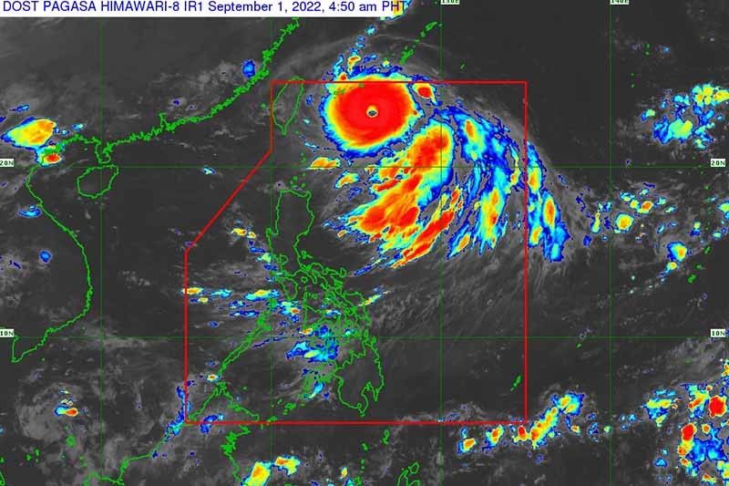
Weather specialist Benison Estareja said in a press briefing that ‘Gardo’ is last located at 1,040 km of east northeast of extreme northern Luzon, with maximum winds at 55/70 kph.
Estareja said that in the next hours, it is possible that ‘Gardo’ will weaken into low pressure area and be absorbed by ‘Henry.’
Meanwhile, ‘Henry’ continues to maintain its strength as it moves over the Philippine sea, state weather bureau PAGASA said.
In its 5:00 a.m. bulletin, PAGASA said ‘Henry’ was last located at 530 km east northeast of Itbayat, Batanes.
The super typhoon packs a maximum sustained wind of 185 kph near the center and gustiness of up to 230 kph.
‘Henry’ continues on its track heading southwestward at 25 kph, PAGASA said.
“This tropical cyclone is also forecast to enhance the Southwest Monsson which may bring rains over the western section of Luzon beginning tomorrow (Friday),” PAGASA said.
It added that issuance of weather advisory for the southwest monsoon or habagat is likely to be given.
Batanes
Batanes may experience light to moderate with at times heavy rains late afternoon until evening, while on Friday, Batanes and Babuyan islands are forecast to experience moderate to hevy rains.
By Saturday morning until afternoon, moderate to heavy rains may still be experience in Batanes, while the Babuyan Islands can expect moderate with at times heavy rains.
“Under these conditions, isolated to scattered flooding (including flash floods) and rain-induced landslides are possible especially in areas that are highly or very highly susceptible to these hazard as identified in hazard maps, and in localities with significant antecedent rainfall,” PAGASA also said.
TCWS, gale warning
PAGASA said ‘Henry’ packs strong to typhoon-force winds that extend outwards up to 340 km from the center. Due to this, it is likely that Tropical Cyclone Wind Signals may be raised for localities in extreme northern Luzon.
“The potential for hoisting a Wind Signal No. 2 is also not ruled out,” the state weather bureau added.
A gale warning is also in effect for the northern and eastern seaboards of Northern Luzon. ‘Henry,’ in the next 24 hours, may bring moderate to rough seas over the eastern seaboard of Isabela which is risky for small seacrafts.
Mariners are told to take precautionary measures when venturing out to the waters and if possible, avoid navigating under the said conditions.
Track and intensity
‘Henry’ is forecast to continue moving generally southwestward on Thursday until Friday morning while decelerating. By Thursday night or early Friday morning, ‘Henry’ may be almost stationary.
Midday Friday, the typhoon may begin moving slowly northwestward before eventually accelerating northward by Saturday.
‘Henry’ is forecast to exit the Philippine area of responsibility on Saturday evening or Sunday morning.
The typhoon may also slightly re-intensify before it decelerates or goes into its quasi-stationary phase, when it is likely to weaken, PAGASA said.
Henry’s track
- 2:00 p.m., September 1: 405 km east northeast of Itbayat, Batanes
- 2:00 a.m., September 2: 375 km east northeast of Itbayat, Batanes
- 2:00 p.m., September 2: 365 km northeast of Itbayat, Batanes
- 2:00 a.m., September 3: 355 km northeast of Itbayat, Batanes
- 2:00 p.m., September 3: 445 km northeast of Itbayat, Batanes
- 2:00 a.m., September 4: 575 km north northeast of Itbayat, Batanes (outside PAR)
- 2:00 a.m., September 5: 875 north northeast of extreme northern Luzon (outside PAR)


- Latest
- Trending