


'Odette' brings heavy rains to Palawan, parts of Visayas
MANILA, Philippines (Updated 3:29 p.m.) — State weather bureau PAGASA said Friday afternoon that Typhoon Odette (international name: Rai) will bring destructive winds and heavy rains to parts of Palawan.
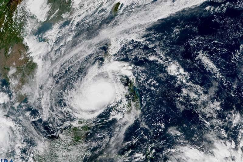
Odette, the strongest storm to make landfall in the disaster-prone Philippines this year, was sighted 130 kilometers southwest of Cuyo in Palawan or 155 km east northeast of Puerto Princesa City at 1 p.m.
The typhoon maintained its strength en route to Palawan, with maximum sustained winds of 155 km per hour near the center and gusts of up to 215 kph.
Odette, heading west at 25 kph, is forecast to make landfall in the vicinity of northern or central portion of Palawan this afternoon.
The state weather bureau raised Tropical Cyclone Wind Signals over the following areas:
TCWS No. 3
(Destructive typhoon-force winds prevailing or expected within 18 hours)
• Northern portion of Palawan (El Nido, Taytay, Araceli, Dumaran, Roxas, San Vicente, Puerto Princesa City) including Cagayancillo and Cuyo Islands
“Destructive typhoon-force winds will be experienced within any of the areas where TCWS No. 3 is in effect. This may bring moderate to heavy damage to structures and vegetation,” PAGASA said.
TCWS No. 2
(Damaging gale- to storm-force winds prevailing or expected within 24 hours)
• Southern portion of Oriental Mindoro (Bulalacao, Masalay, Roxas)
• Southern portion of Occidental Mindoro (Calintaan, Rizal, San Jose, Magsaysay)
• Central portion of Palawan (Narra, Sofronio Española, Quezon, Aborlan, Rizal, Brooke's Point) including Kalayaan and Calamian Islands
• Southwestern portion of Negros Occidental (Cauayan, Candoni, Ilog, Hinoba-An, City of Sipalay), Antique
• Northwestern and western portions of Aklan (Malinao, Madalag, Libacao, Buruanga)
• Southwestern portion of Capiz (Jamindan, Tapaz)
• Central and southern portions of Iloilo (Bingawan, Calinog, Dueñas, Lambunao, Badiangan, Janiuay, Cabatuan, Mina, New Lucena, Maasin, Alimodian, Leon, Zarraga, Pototan, Santa Barbara, Leganes, Iloilo City, Pavia, Oton, San Miguel, Tigbauan, Igbaras, Tubungan, Guimbal, Miagao, San Joaquin)
• Guimaras
TCWS No. 1
(Strong winds prevailing or expected within 36 hours)
• Batangas
• Southeastern portion of Quezon (San Francisco, San Andres, San Narciso, Mulanay, Catanauan)
• Marinduque
• Masbate (Esperanza, Mandaon, Palanas, Baleno, Placer, Cawayan, Milagros, Dimasalang, Uson, Cataingan, Pio V. Corpuz, Balud, City of Masbate, Aroroy, Mobo)
• Romblon
• Western portion of Bohol (Getafe, Talibon, Trinidad, Bien Unido, San Miguel, Dagohoy, Carmen, Dimiao, Danao, Buenavista, Inabanga, Sagbayan, Clarin, Catigbian, Batuan, Bilar, Lila, Loay, Loboc, Sevilla, Tubigon, Balilihan, San Isidro, Calape, Loon, Antequera, Maribojoc, Cortes, Corella, Sikatuna, Alburquerque, Baclayon, Tagbilaran City, Dauis, Panglao)
• Siquijor
• Cebu including Bantayan Islands
• Rest of Negros Occidental
• Negros Oriental
• Rest of Capiz
• Rest of Iloilo
• Rest of Aklan
• Northern portion of Zamboanga del Norte (Baliguian, Gutalac, Kalawit, Labason, Liloy, Tampilisan, Salug, Godod, Bacungan, Sindangan, Siayan, Jose Dalman, Manukan, Pres. Manuel A. Roxas, Katipunan, Sergio Osmeña Sr., Dipolog City, Polanco, Piñan, Mutia, Dapitan City, La Libertad, Sibutad, Rizal)
• Northern portion of Misamis Occidental (Don Victoriano Chiongbian, Aloran, Oroquieta City, Lopez Jaena, Concepcion, Sapang Dalaga, Calamba, Baliangao, Plaridel)
What to expect
Heavy to torrential rains
• Western Visayas
• Palawan including Calamian, Cuyo, and Cagayancillo Islands
• Negros Oriental
Moderate to heavy with at times intense rains
• Bicol region
• Zamboanga Peninsula
• Quezon
• Rest of MIMAROPA
Light to moderate with at times heavy rains
• Cagayan Valley
• Rest of CALABARZON
• Cordillera Administrative Region
• Aurora
• Lanao del Norte
• Misamis Occidental
• Lanao del Sur
• Rest of Visayas
Moderate to high risk of storm surge of up to 3 meters
• Low-lying coastal areas of Antique
• Several localities of Aklan and Palawan (Calamian, Cuyo and Cagayancillo Islands)
According to PAGASA, Odette will re-emerge over the West Philippine Sea Friday evening, and pass in the vicinity of Kalayaan Islands Saturday morning. It is seen to exit the Philippine Area of Responsibility Saturday morning or early afternoon.
“Odette may still see some slight weakening until it crosses Palawan, but it is forecast to remain as a typhoon. Re-intensification is likely once it emerges over the West Philippine Sea,” the weather bureau added.
More than 300,000 people fled their homes as the typhoon battered the country.
According to the National Disaster Risk Reduction Management Council, one people had been killed.
Track
• Friday evening: 135 km northwest of Puerto Princesa City, Palawan
• Saturday evening: over the coastal waters of Pag-asa Island, Kalayaan, Palawan (outside PAR)
• Saturday evening: 240 km west northwest of Pag-asa Island, Kalayaan, Palawan (outside PAR)
• Sunday morning: 240 km northwest of Pag-asa Island, Kalayaan, Palawan (outside PAR)
• Sunday evening: 1,085 km west of Central Luzon (outside PAR)
• Monday morning: 975 km west of extreme Northern Luzon (outside PAR)
• Monday evening: 690 km west of Calayan, Cagayan (outside PAR)
— Gaea Katreena Cabico


- Latest
- Trending


