


Storm signals up in Mindanao as 'Crising' strengthens to tropical storm
MANILA, Philippines — PAGASA on Thursday said Tropical Depression "Crising" has intensified into a tropical storm and placed more areas now under its storm signals.
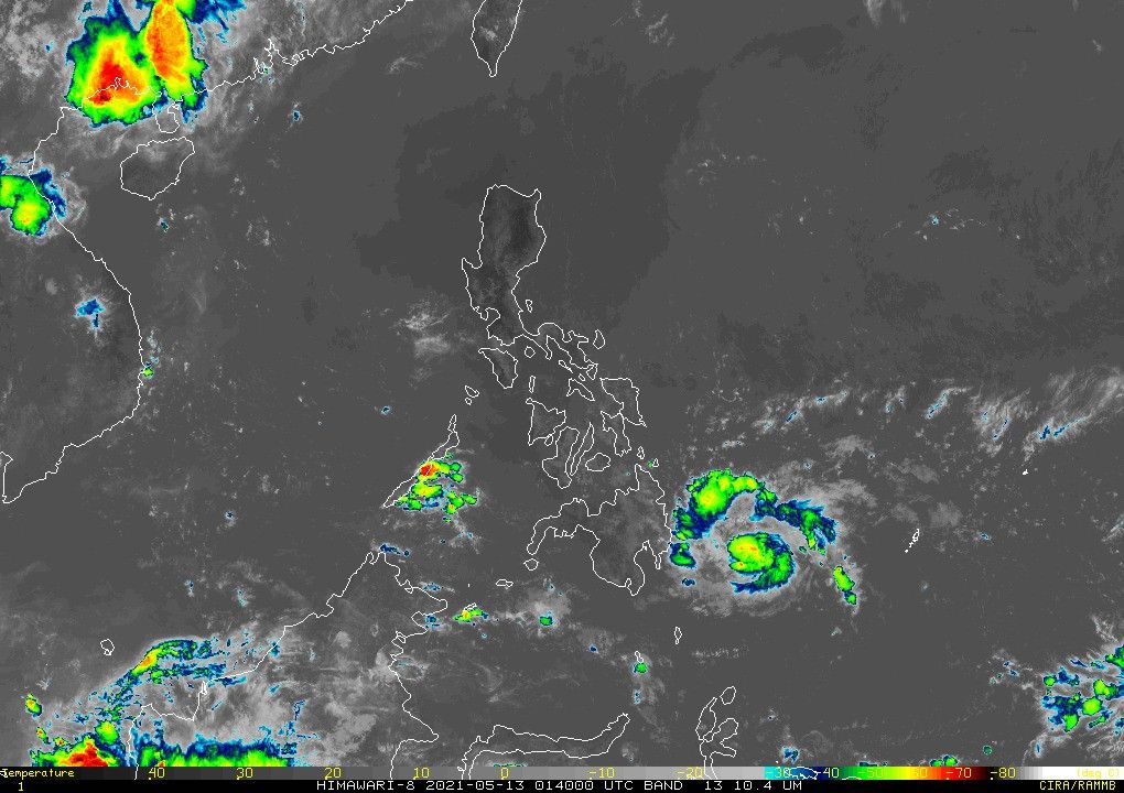
The agency in its 11 a.m. bulletin said Crising was last seen at 330 kilometers east of Davao City. It became a tropical depression from a low pressure area early this morning.
Crising now carries 65 kilometers per hour peak winds and gusts of up to 80 kph. It continues to move at a speed of 10 kph at a west northwestward direction.
Signal No. 2:
- The southern portion of Surigao del Sur (Lingig, City of Bislig)
- southeastern portion of Agusan del Sur (Trento, Santa Josefa)
- northern portion of Davao Oriental (Boston, Cateel, Baganga)
- northeastern portion of Davao de Oro (Compostela, Montevista, Monkayo, New Bataan)
Signal No. 1:
- The rest of Surigao del Sur
- rest of Agusan del Sur
- rest of Davao Oriental
- rest of Davao de Oro
- Davao del Norte
- Davao City
- eastern portion of Bukidnon (Impasug-Ong, City of Malaybalay, Cabanglasan, San Fernando, Quezon, City of Valencia, Lantapan, Maramag, Dangcagan, Kitaotao, Don Carlos, Kibawe, Damulog)
The tropical storm is expected to make landfall over Surigao del Sur-Davao Oriental area between tonight and early Friday morning.
PAGASA said Surigao del Sur, Agusan del Sur, Davao Oriental, Davao de Oro and Davao del Norte will experience moderate to heavy rains starting today until tomorrow due to Crising.
"Under these conditions, isolated to scattered flooding (including flash floods) and rain-induced landslides are possible during heavy or prolonged rainfall especially in areas that are highly or very highly susceptible to these hazards as identified in hazard maps," PAGASA added. "Adjacent or nearby areas may also experience flooding in the absence of such rainfall occurrence due to surface runoff or swelling of river channels."
Crising is forecast to weaken throughout Friday, when it moves toward the rugged landmass of Mindanao.
By weekend, it will emerge over Sulu Sea as a low pressure area, where it is seen to eventually dissipate while passing over Palawan.
The Philippines sees 20 typhoons on average per year. Three have since entered the country this 2021.
PAGASA said Crising will bring moderate to rough seas over the eastern seaboard of Mindanao, with wave height reaching between 1.2 to 3 meters. It advised small seacrafts and inexperienced mariners not to venture over these waters in the next 24 hours.
Forecast Position
- Friday morning: In the vicinity of Boston, Davao Oriental
- Saturday morning: 120 km West Southwest of Dumaguete City, Negros Oriental
- Sunday morning: 50 km West of Puerto Princesa City, Palawan


- Latest
- Trending


