


#FalconPH
The Department of Social Welfare and Development (DSWD) distributes financial aid to residents most affected by typhoons Falcon and Egay, the Philippine New Agency reports.
Residents receives P3,000 each to 1,000 residents as part of the Assistance to Individuals in Crisis Situation of the DSWD whose beneficiaries here are senior citizens, tricycle drivers, solo parents, and persons with disabilities.
According to the report, Falcon, Egay and the southwest monsoon affected a total of 112,756 families in Pangasinan.
Typhoon "Falcon" is now outside the Philippine Area of Responsibility, the state weather bureau reports on Tuesday afternoon.
As of 4 p.m., the center of the eye of the typhoon was estimated based on all available data at 835 km Northeast of Extreme Northern Luzon (25.1°N, 128.5°E).
"Falcon" packs maximum sustained winds of 175 kilometer per hour near the center, gustiness of up to 215 km/h, and central pressure of 935 hPa.
PAGASA says "the Southwest Monsoon enhanced by Falcon will bring occasional to monsoon rains over the western portion of Luzon in the next three days."
PAGASA says Typhoon Falcon maintains its strength while moving towards the sea southeast of Okinawa Islands.
As of 10 a.m. Tuesday, Falcon was found 875 kilometers east northeast of extreme northern Luzon.
Moving west northwestward at 20 kilometers per hour, it has peak sustained winds of 175 kph near the center and gustiness of up to 215 kph.
PAGASA says Typhoon Falcon maintains its strength as it moves towards the sea southeast of Okinawa Islands.
In its 5 a.m. cyclone bulletin, Falcon was spotted 925 kilometes east northeast of extreme northern Luzon.
Moving northwestward at 20 kilometers per hour, it has maximum sustained winds of 175 kph near the center and gustiness of up to 215 kph.
Typhoon Falcon intensifies while moving north northwestward over the Philippine sea, according to the state weather bureau.
As of 4 p.m. Falcon's center of the eye was estimated based on all available data at 1,020 km East Northeast of Extreme Northern Luzon (23.0°N, 131.4°E)
It packs maximum sustained winds of 165 kilometer per hour near the center, gustiness of up to 205 km/h, and central pressure of 940 hPa.
The state weather bureau reports that the southwest monsoon enhanced by Typhoon Falcon may bring more rains in the next three days.
It advises the public of potential flooding and rain-induced landslides in areas that are highly or very highly susceptible to these hazards.
The state weather bureau, in its latest weather bulletin, reports that Typhoon Falcon further intensified.
The typhoon is moving north northwestward and its center of the eye was last located at 1,070 km East of Extreme Northern Luzon (21.5°N, 132.1°E)
"Falcon" packs maximum sustained winds of 150 kilometer per hour near the center, gustiness of up to 185 km/h, and central pressure of 950 hPa.
Severe Tropical Storm ‘Falcon’ has intensified as it accelerates northward over the Philippine sea, state weather forecasters says in a 5 p.m. bulletin.
Falcon is forecast to steadily gain more strength within the next three days. It is expected to become a typhoon between tonight or tomorrow early morning and reach its peak intensity on Tuesday.
Meanwhile, Falcon will continue to enhance the southwest monsoon, affecting the western portions of Luzon and Visayas in the next three days.
Severe Tropical Storm “Falcon” maintains its strength as it moves north northwestward, the state weather bureau says in an 11 a.m. bulletin.
'Falcon' has instensified into a severe tropical storm, state weather forecasters say in a 5 a.m. bulletin.
The southwest monsoon enhanced by Falcon will bring occasional to monsoon rains over the western portions of Luzon and Visayas in the next three days.
State bureau says Tropical Storm Falcon intensifies as it accelerates northward over the Philippine Sea.
In its 5 p.m. cyclone bulletin, Falcon was found 1,205 kilometers east of central Luzon.
It has maximum sustained winds of 75 kilometers per hour near the center and gustiness of up to 90 kph.
PAGASA says that Tropical Storm Falcon decelerates as it moves westward over the Philippine Sea.
In its 11 a.m. cyclone bulletin on Saturday, Falcon was spotted 1,315 kilometers east of central Luzon.
Falcon has peak sustained winds of 65 kilometers per hour near the center and gustiness of up to 80 kph.
It is now moving westward at 10 kph.
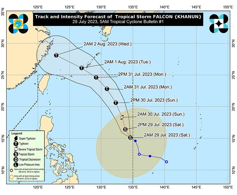
PAGASA says Tropical Storm Khanun has entered the Philippine Area of Responsibility and was locally named "Falcon."
Falcon was last seen 1,360 kilometers east of central Luzon.
Moving west northwestward at 15 kilometers per hour, it has maximum sustained winds of 65 kph near the center and gustiness of up to 80 kph.
Bookmark this page for updates on "Falcon," the sixth tropical cyclone to enter the Philippine Area of Responsibility.


- Latest
- Trending


