+ Follow PUBLIC STORM WARNING SIGNAL NO Tag
Array
(
[results] => Array
(
[0] => Array
(
[ArticleID] => 1532231
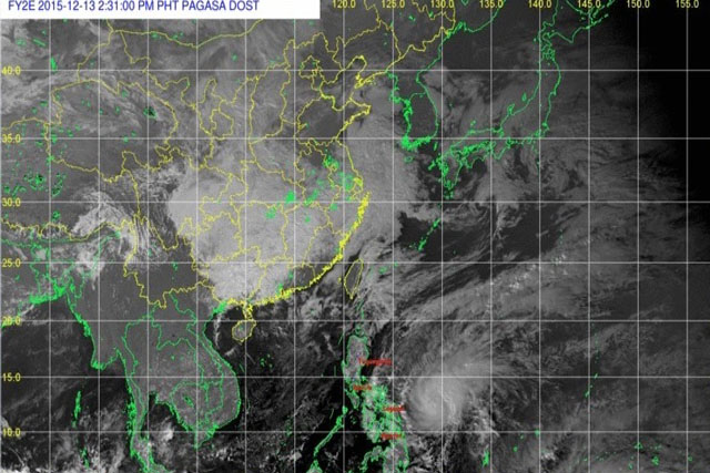
[Title] => Gov’t braces for Storm Nona's landfall
[Summary] => President Benigno Aquino III has been monitoring the severe tropical storm to ensure preparedness for its anticipated landfall, Malacañang said on Sunday.
[DatePublished] => 2015-12-13 01:59:37
[ColumnID] => 0
[Focus] => 0
[AuthorID] => 1804517
[AuthorName] => Rosette Adel
[SectionName] => Headlines
[SectionUrl] => headlines
[URL] => http://media.philstar.com/images/the-philippine-star/headlines/20151213/tropical-storm-nona.jpg
)
[1] => Array
(
[ArticleID] => 1370450
[Title] => 'Mario' magiging malupit na bagyo sa Biyernes
[Summary] => Inaasahang magiging malupit na bagyo si "Mario" bago pa ito humampas sa kalupaan ng probinsya ng Cagayan sa Biyernes ng gabi.
[DatePublished] => 2014-09-18 12:52:44
[ColumnID] => 0
[Focus] => 0
[AuthorID] =>
[AuthorName] =>
[SectionName] => Bansa
[SectionUrl] => bansa
[URL] => http://media.philstar.com/images/the-philippine-star/headlines/20140918/tropical-storm-mario-northern-luzon.jpg
)
[2] => Array
(
[ArticleID] => 1244030
[Title] => 'Santi' intensifies into typhoon; 33 Luzon areas under storm alert
[Summary] => Storm alerts were raised over 33 areas in Luzon as “Santi” intensified into a typhoon Friday morning.
[DatePublished] => 2013-10-11 06:54:20
[ColumnID] => 0
[Focus] => 0
[AuthorID] =>
[AuthorName] =>
[SectionName] => Nation
[SectionUrl] => nation
[URL] => http://img547.imageshack.us/img547/3712/v7i0.jpg
)
[3] => Array
(
[ArticleID] => 1144021
[Title] => 'Nando' out of PAR by Thursday: PAGASA
[Summary] => Tropical Storm "Nando" is expected to be out of the Philippine Area of Responsibility (PAR) by tomorrow, state weather bureau PAGASA said Wednesday.
[DatePublished] => 2013-08-28 09:01:30
[ColumnID] => 0
[Focus] => 0
[AuthorID] => 1473499
[AuthorName] => Louis Bacani
[SectionName] => Nation
[SectionUrl] => nation
[URL] =>
)
[4] => Array
(
[ArticleID] => 1140211
[Title] => 'Nando,' Habagat may bring heavy rains in Metro Manila, Luzon
[Summary] => Tropical Storm "Nando" and the southwest monsoon or Habagat may bring heavy rains over Metro Manila and other areas in Luzon, state weather bureau PAGASA warned Tuesday.
[DatePublished] => 2013-08-27 13:35:28
[ColumnID] => 0
[Focus] => 0
[AuthorID] => 1473499
[AuthorName] => Louis Bacani
[SectionName] => Nation
[SectionUrl] => nation
[URL] => http://img856.imageshack.us/img856/1609/0vhk.jpg
)
[5] => Array
(
[ArticleID] => 1082161
[Title] => 'Labuyo' weakens; to exit PAR on Tuesday
[Summary] => Typhoon "Labuyo" has weakened while crossing northern Luzon and will exit Philippine landmass early this afternoon, the state weather bureau said Monday.
[DatePublished] => 2013-08-12 11:37:25
[ColumnID] => 0
[Focus] => 0
[AuthorID] => 1473499
[AuthorName] => Louis Bacani
[SectionName] => Headlines
[SectionUrl] => headlines
[URL] => http://img809.imageshack.us/img809/6047/dqf9.jpg
)
[6] => Array
(
[ArticleID] => 463246
[Title] => Weather (May 03, 2009)
[Summary] => At 4 p.m. yesterday, the center of tropical depression “Dante” was estimated at 20 kms east of Virac, Catanduanes with maximum sustained winds of 55 kph near the center.
[DatePublished] => 2009-05-03 00:00:00
[ColumnID] => 133272
[Focus] => 0
[AuthorID] =>
[AuthorName] =>
[SectionName] => Weather
[SectionUrl] => weather
[URL] =>
)
[7] => Array
(
[ArticleID] => 463019
[Title] => Weather (May 02, 2009)
[Summary] => At 4 p.m. yesterday, the center of tropical depression “Dante” was estimated at 80 kms east of Legazpi City, Albay with maximum sustained winds of 55 kph near the center.
[DatePublished] => 2009-05-02 00:00:00
[ColumnID] => 133272
[Focus] => 0
[AuthorID] =>
[AuthorName] =>
[SectionName] => Weather
[SectionUrl] => weather
[URL] =>
)
[8] => Array
(
[ArticleID] => 399649
[Title] => Weather Forecast
[Summary] => At 2 a.m. today, the eye of Typhoon "Marce" was located at 230 kms East of Basco, Batanes with maximum sustained winds of 160 kph near the center and gustiness of up to 195 kph.
[DatePublished] => 2008-09-11 00:00:00
[ColumnID] => 133272
[Focus] => 0
[AuthorID] =>
[AuthorName] =>
[SectionName] => Weather
[SectionUrl] => weather
[URL] =>
)
[9] => Array
(
[ArticleID] => 374444
[Title] => Todays Weather
[Summary] => Tropical storm "Seniang" was estimated at 4 p.m. yesterday at 90 kms northwest of San Jose, Occidental Mindoro with maximum sustained winds of 120 kph near the center and gustiness of up to 150 kph.
"Seniang" is expected to be at 390 kms northwest of Coron, Palawan this afternoon. It will be over the South China Sea tomorrow afternoon.
At 4 p.m. yesterday, Public Storm Warning Signal No. 3 was hoisted over Mindoro Occidental and the Calamian group of islands, which would have winds of 101-185 kph.
[DatePublished] => 2006-12-11 00:00:00
[ColumnID] => 133272
[Focus] => 0
[AuthorID] =>
[AuthorName] =>
[SectionName] => Weather
[SectionUrl] => weather
[URL] =>
)
)
)
PUBLIC STORM WARNING SIGNAL NO
Array
(
    [results] => Array
        (
            [0] => Array
                (
                    [ArticleID] => 1532231
                    [Title] => Gov’t braces for Storm Nona's landfall
                    [Summary] => President Benigno Aquino III has been monitoring the severe tropical storm to ensure preparedness for its anticipated landfall, Malacañang said on Sunday.

                    [DatePublished] => 2015-12-13 01:59:37
                    [ColumnID] => 0
                    [Focus] => 0
                    [AuthorID] => 1804517
                    [AuthorName] => Rosette Adel
                    [SectionName] => Headlines
                    [SectionUrl] => headlines
                    [URL] => http://media.philstar.com/images/the-philippine-star/headlines/20151213/tropical-storm-nona.jpg
                )

            [1] => Array
                (
                    [ArticleID] => 1370450
                    [Title] => 'Mario' magiging malupit na bagyo sa Biyernes
                    [Summary] => Inaasahang magiging malupit na bagyo si "Mario" bago pa ito humampas sa kalupaan ng probinsya ng Cagayan sa Biyernes ng gabi.

                    [DatePublished] => 2014-09-18 12:52:44
                    [ColumnID] => 0
                    [Focus] => 0
                    [AuthorID] =>
                    [AuthorName] =>
                    [SectionName] => Bansa
                    [SectionUrl] => bansa
                    [URL] => http://media.philstar.com/images/the-philippine-star/headlines/20140918/tropical-storm-mario-northern-luzon.jpg
                )

            [2] => Array
                (
                    [ArticleID] => 1244030
                    [Title] => 'Santi' intensifies into typhoon; 33 Luzon areas under storm alert
                    [Summary] => Storm alerts were raised over 33 areas in Luzon as “Santi” intensified into a typhoon Friday morning.

                    [DatePublished] => 2013-10-11 06:54:20
                    [ColumnID] => 0
                    [Focus] => 0
                    [AuthorID] =>
                    [AuthorName] =>
                    [SectionName] => Nation
                    [SectionUrl] => nation
                    [URL] => http://img547.imageshack.us/img547/3712/v7i0.jpg
                )

            [3] => Array
                (
                    [ArticleID] => 1144021
                    [Title] => 'Nando' out of PAR by Thursday: PAGASA
                    [Summary] => Tropical Storm "Nando" is expected to be out of the Philippine Area of Responsibility (PAR) by tomorrow, state weather bureau PAGASA said Wednesday.

                    [DatePublished] => 2013-08-28 09:01:30
                    [ColumnID] => 0
                    [Focus] => 0
                    [AuthorID] => 1473499
                    [AuthorName] => Louis  Bacani
                    [SectionName] => Nation
                    [SectionUrl] => nation
                    [URL] =>
                )

            [4] => Array
                (
                    [ArticleID] => 1140211
                    [Title] => 'Nando,' Habagat may bring heavy rains in Metro Manila, Luzon
                    [Summary] => Tropical Storm "Nando" and the southwest monsoon or Habagat may bring heavy rains over Metro Manila and other areas in Luzon, state weather bureau PAGASA warned Tuesday.

                    [DatePublished] => 2013-08-27 13:35:28
                    [ColumnID] => 0
                    [Focus] => 0
                    [AuthorID] => 1473499
                    [AuthorName] => Louis  Bacani
                    [SectionName] => Nation
                    [SectionUrl] => nation
                    [URL] => http://img856.imageshack.us/img856/1609/0vhk.jpg
                )

            [5] => Array
                (
                    [ArticleID] => 1082161
                    [Title] => 'Labuyo' weakens; to exit PAR on Tuesday
                    [Summary] => Typhoon "Labuyo" has weakened while crossing northern Luzon and will exit Philippine landmass early this afternoon, the state weather bureau said Monday.

                    [DatePublished] => 2013-08-12 11:37:25
                    [ColumnID] => 0
                    [Focus] => 0
                    [AuthorID] => 1473499
                    [AuthorName] => Louis  Bacani
                    [SectionName] => Headlines
                    [SectionUrl] => headlines
                    [URL] => http://img809.imageshack.us/img809/6047/dqf9.jpg
                )

            [6] => Array
                (
                    [ArticleID] => 463246
                    [Title] => Weather (May 03, 2009)
                    [Summary] => At 4 p.m. yesterday, the center of tropical depression “Dante” was estimated at 20 kms east of Virac, Catanduanes with maximum sustained winds of 55 kph near the center.
                    [DatePublished] => 2009-05-03 00:00:00
                    [ColumnID] => 133272
                    [Focus] => 0
                    [AuthorID] =>
                    [AuthorName] =>
                    [SectionName] => Weather
                    [SectionUrl] => weather
                    [URL] =>
                )

            [7] => Array
                (
                    [ArticleID] => 463019
                    [Title] => Weather (May 02, 2009)
                    [Summary] =>  At 4 p.m. yesterday, the center of tropical depression “Dante” was estimated at 80 kms east of Legazpi City, Albay with maximum sustained winds of 55 kph near the center.
                    [DatePublished] => 2009-05-02 00:00:00
                    [ColumnID] => 133272
                    [Focus] => 0
                    [AuthorID] =>
                    [AuthorName] =>
                    [SectionName] => Weather
                    [SectionUrl] => weather
                    [URL] =>
                )

            [8] => Array
                (
                    [ArticleID] => 399649
                    [Title] => Weather Forecast
                    [Summary] => At 2 a.m. today, the eye of Typhoon "Marce" was located  at 230 kms East of Basco, Batanes  with maximum sustained winds of 160 kph near the center and gustiness of up to 195 kph.
                    [DatePublished] => 2008-09-11 00:00:00
                    [ColumnID] => 133272
                    [Focus] => 0
                    [AuthorID] =>
                    [AuthorName] =>
                    [SectionName] => Weather
                    [SectionUrl] => weather
                    [URL] =>
                )

            [9] => Array
                (
                    [ArticleID] => 374444
                    [Title] => Todays Weather
                    [Summary] => Tropical storm "Seniang" was estimated at 4 p.m. yesterday at 90 kms northwest of San Jose, Occidental Mindoro with maximum sustained winds of 120 kph near the center and gustiness of up to 150 kph.


"Seniang" is expected to be at 390 kms northwest of Coron, Palawan this afternoon. It will be over the South China Sea tomorrow afternoon.


At 4 p.m. yesterday, Public Storm Warning Signal No. 3 was hoisted over Mindoro Occidental and the Calamian group of islands, which would have winds of 101-185 kph.


                    [DatePublished] => 2006-12-11 00:00:00
                    [ColumnID] => 133272
                    [Focus] => 0
                    [AuthorID] =>
                    [AuthorName] =>
                    [SectionName] => Weather
                    [SectionUrl] => weather
                    [URL] =>
                )

        )

)
abtest
September 18, 2014 - 12:52pm
October 11, 2013 - 6:54am
September 11, 2008 - 12:00am
December 11, 2006 - 12:00am