


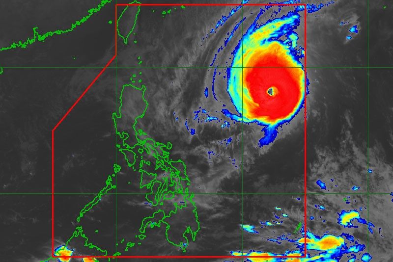
Typhoon Rosita enters PAR
MANILA, Philippines — The National Disaster Risk Reduction and Management Council (NDRRMC) convened yesterday in line with its pre-disaster mitigation efforts as Typhoon Rosita (international name Yutu) entered the Philippine area of responsibility (PAR) yesterday morning.
Ricardo Jalad, NDRRMC administrator and Office of Civil Defense executive director, warned the public on the possible disastrous effects of the typhoon, saying it is expected to dump moderate to heavy rains.
Agencies under the NDRRMC’s response cluster came up with measures to mitigate the impact of the typhoon, including the stockpiling of food and non-food items by the Department of Social Welfare and Development and medicine and medical supplies by the Department of Health.
The Armed Forces of the Philippines, Philippine National Police, Bureau of Fire Protection and Philippine Coast Guard committed their respective disaster response assets. The Departments of Public Works and Highways, Education and Foreign Affairs activated their respective typhoon monitoring units
“The NDRRMC operation center is on white alert... We will raise it to blue... to closely monitor the possible effects of the current weather system and ensure efficient coordination among member agencies,” Jalad said.
Strong rains, winds
The Philippine Atmospheric, Geophysical and Astronomical Services Administration (PAGASA) said most parts of Luzon, including Metro Manila, should brace for moderate to strong rains and winds.
PAGASA said Rosita has slightly intensified as it entered the PAR at around 6:30 a.m., with maximum winds of 200 kilometers per hour and gustiness of up to 245 kph.
As of 10 a.m. yesterday, the eye of the typhoon was located 1,345 kilometers east of Aparri, Cagayan with a diameter of 800 kilometers. The typhoon was moving west at 20 kph.
Aldczar Aurelio, PAGASA weather forecaster, said Rosita was expected to make landfall in the Cagayan-Isabela area on Tuesday morning.
Aurelio said the typhoon would bring “strong to very strong winds” and “moderate to heavy rains” over Luzon.
“Moderate to heavy rains directly associated with the typhoon is expected over Northern and Central Luzon starting tomorrow night,” PAGASA said.
Esperanza Cayanan, PAG-ASA weather division chief, advised those traveling to the provinces in observance of All Saints’ Day and All Souls’ Day to plan their trips ahead of the raising of storm warning signals.
No classes in Isabela, Cagayan
Meanwhile, the provincial governments of Isabela and Cagayan announced yesterday the suspension of classes in all levels in both public and private schools tomorrow.
Govs. Faustino Dy III of Isabela and Manuel Mamba of Cagayan issued the orders after meeting with their respective provincial disaster risk reduction and management councils.
Dy said the provincial social welfare office has prepositioned an initial 5,000 relief boxes in remote areas, particularly in the coastal towns of Maconacon, Divilacan, Palanan and Dinapigue. – With Raymund Catindig


- Latest
- Trending


