


'Marce' to exit PAR on Monday
November 27, 2016 | 11:39am
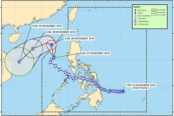
Track of Marce as of Sunday, November 27, according to PAGASA's 11 a.m. severe weather bulletin.
PAGASA / Released
MANILA, Philippines — Tropical storm Marce (international name: Tokage) is expected to exit the Philippine area of responsibility (PAR) on Monday as it continues to move slowly in a north-northwest direction, the Philippine Atmospheric, Geophysical and Astronomical Services Administration (PAGASA) said Sunday.
In its 11 a.m. bulletin, the state weather bureau said that the eye of "Marce" was estimated to be located at 305 km west of Dagupan City, Pangasinan at 10 a.m. Sunday. It is forecast to move north-northwest at 11 kph.
It packs maximum sustained winds of up to 85 kph near the center and gustiness of up to 105 kph.
PAGASA said that it brings an estimated moderate to heavy rainfall amount within its 400 km diameter but added that it would have "no direct affect to any part of the country."
No tropical cyclone warning signal is raised by PAGASA.
Forecast positions
- 24 hours (Monday morning): 385 km west of Sinait, Ilocos Sur (outside PAR)
- 48 hours (Tuesday morning): 685 km north of Pagasa Island, Palawan (outside PAR)
- 72 hours (Wednesday morning): 545 km northwest of Pagasa Island, Palawan (outside PAR)
BrandSpace Articles


<
>
- Latest
- Trending
Trending
Latest
Trending

By Andrew Ronquillo | 3 days ago

By John Unson | 8 hours ago

By John Unson | 8 hours ago

By Bella Cariaso | 2 days ago

Latest


By Rudy Santos | 1 hour ago

By Bella Cariaso | 1 hour ago

By John Unson | 1 hour ago

By Andrew Ronquillo | 1 hour ago

Recommended

1 day ago

1 day ago
June 13, 2026 - 12:00am


1 day ago
