Weather updates
The state weather bureau in its weather forecast says that the northeasterly surface windflow continues to affect Northern Luzon this Wednesday
The northeasterly surface window will bring cloudy skies with rains in Batanes, Cagayan, Isabela and Aurora.
PAGASA adds that the northeasterly windflow will cause partly cloudy to cloudy skies with isolated rainshowers or thunderstorms in Metro Manila and the rest of the country. It will also be affected by localized thunderstorm. — Rosette Adel
The state weather bureau reports that northeasterly surface windflow continues to affect Northern Luzon this Tuesday.
PAGASA says this is bringing cloudy skies with rains in Batanes, Cagayan and Isabela.
Metro Manila and the rest of the country, on the other hand, will experience partly cloudy to cloudy skies with isolated rainshowers or thunderstorms due to the northeasterly surface windflow and localized thunderstorms. — Rosette Adel
The state weather bureau reports that a northeasterly surface windflow is affecting extreme northern Luzon.
In its daily weather forecast, PAGASA says that the northeasterly surface window is bringing partly cloudy to cloudy skies with isolated light rains over Batanes, Cagayan, Isabela and Apayao.
Palawan, on the other hand, is experiencing cloudy skies with scattered rainshowers and thunderstorms due to the trough of a low pressure area.
Meanwhile, Metro Manila and the rest of the country will experience partly cloudy to cloudy skies with isolated rainshowers or thunderstorms due to localized thunderstorms. — Rosette Adel
The state weather bureau reports that Metro Manila and the rest of the country will experience partly cloudy to cloudy skies with isolated rainshowers or thunderstorms. It says that this is affected by the trough of a low pressure area or localized thunderstorms.
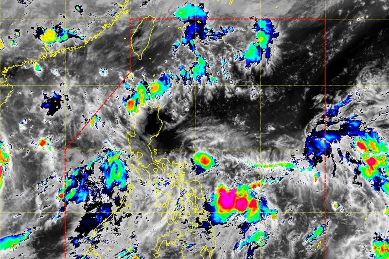
As of 3 a.m., PAGASA reports that the LPA has been estimated based on all available data at 305 kilometers West of Puerto Princesa City, Palawan (9.6°North, 116.0°East).
The trough of LPA is also affecting Occidental Mindoro and the northern portion of Palawan that if forecasts to experience cloudy skies with scattered rainshowers and thunderstorms.
Batanes, Cagayan, Isabela, Apayao, and Abra may also experience artly cloudy to cloudy skies with light rains due to northeasterly surface windflow. —Rosette Adel
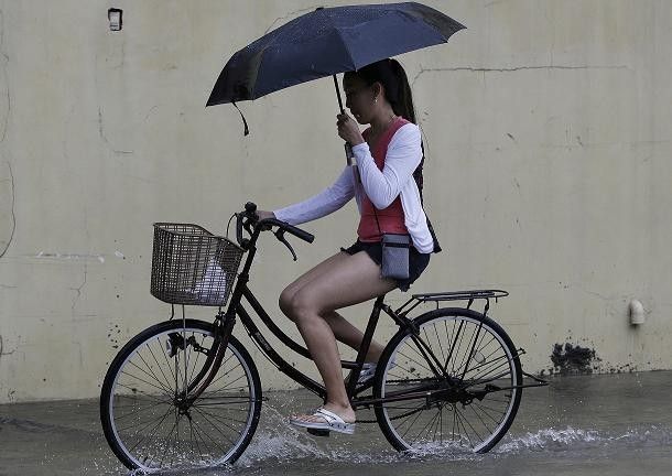
The trough of a low pressure area (LPA) will bring cloudy skies with scattered rain showers and thunderstorms over Metro Manila, Visayas, Mindanao, Bicol Region, Mimaropa, and Calabarzon this Wednesday, according to the state weather bureau.
At 3 a.m., the LPA was estimated based on all available data at 750 kilometers East of Guiuan, Eastern Samar (9.8°North, 132.5°East). — Rosette Adel
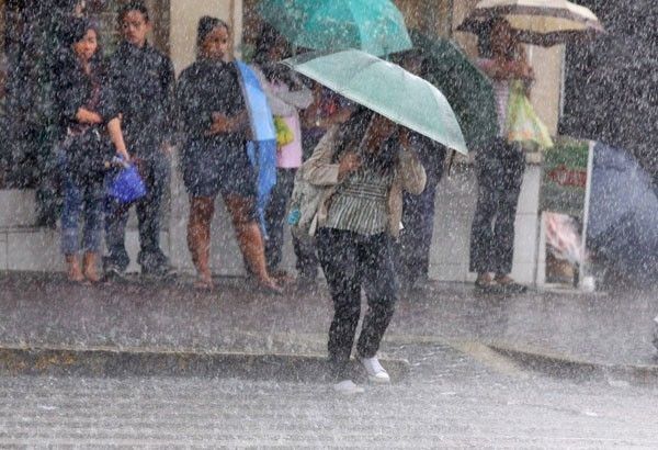
The state weather bureau reports that the trough of a Low Pressure Area (LPA) affecting Visayas and Mindanao.
In its daily weather forecast, PAGASA says that Mindanao, Bicol Region, Eastern Visayas, and Central Visayas will experienceloudy skies with scattered rainshowers and thunderstorms.
On the other hand, Metro Manila and the rest of the country can expect partly cloudy to cloudy skies with isolated rainshowers or thunderstorms. — Rosette Adel
PAGASA reports that the trough of a low pressure area will bring cloudy skies with scattered rain showers and thunderstorms over Mindanao, Eastern Visayas, and Central Visayas this Monday.
On the other hand, Metro Manila and the rest of the country will experience partly cloudy to cloudy skies with isolated rain showers or thunderstorms due to the trough of LPA or localized thunderstorms. — Rosette Adel
Southwest Monsoon is affecting the western section of northern and central Luzon, the state weather bureau says.
PAGASA says Metro Manila and the rest of the country will experience partly cloudy to cloudy skies with isolated rainshowers or thunderstorms.
It also advises residents of possible flash floods or landslides during severe thunderstorms. — Rosette Adel
The state weather bureau reports that the southwest monsoon enhanced by Typhoon Jenny (International name: Koinu) may bring significant amount of rains in the next three days.
The public and disaster risk reduction and management offices concerned are advised to take precautionary measures to protect life and property.
The southwest monsoon enhanced by Typhoon Jenny (International name: Koinu) may bring significant amount of rains in the next three days, according to the state weather bureau.
It says that under these conditions, flooding and rain-induced landslides are possible, especially in areas susceptible to hazards.
The state weather bureau says that the trough of a Low Pressure Area (LPA) affecting the eastern sections of Visayas and Mindanao.
It adds that Southwest Monsoon affecting the western sections of Southern Luzon and Visayas.
Metro Manila and the rest of the country, on the other hand, will experience partly cloudy to cloudy skies with isolated rainshowers or thunderstorms.
The Philippine Institute of Volcanology and Seismology says trough of a Low Pressure Area (LPA) is affecting Visayas and Mindanao.
It adds that cloudy skies with scattered rainshowers and thunderstorms is prevailing over Mindanao, Central Visayas and Eastern Visayas as well as Palawan and Occidental Mindoro.
Metro Manila and the rest of the country are experiencing partly cloudy to cloudy skies with isolated rainshowers or thunderstorms
The state weather bureau says southwest monsoon is affecting the western sections of Southern Luzon and Visayas.
It reports that MIMAROPA, Western Visayas, Central Visayas, Zambales, Bataan, Cavite, and Batangas will experience cloudy skies with scattered rainshowers and thunderstorms.
On the other hand, PAGASA says Eastern Visayas and Masbate will experience cloudy skies with scattered rainshowers and thunderstorms.
Partly cloudy to cloudy skies with isolated rainshowers or thunderstorms will prevail over Metro Manila and the rest of the country.
PAGASA reports that Southwest Monsoon is affecting Southern Luzon, Visayas, and Mindanao.
It adds that the trough of Low Pressure Area affecting the rest of Luzon.
Metro Manila is expected to experience cloudy skies with scattered rainshowers and thunderstorms.
The state weather bureau says an Intertropical Convergence Zone (ITCZ) is affecting Mindanao.
It adds that Metro Manila will experience partly cloudy to cloudy skies with isolated rainshowers or thunderstorms.
The Intertropical Convergence Zone (ITCZ) will continue to affect Mindanao this Monday, September 18, the state weather bureau reports.
PAGASA also says that clloudy skies with scattered rain showers and thunderstorms will be experienced in Mindanao due to ITCZ.
Metro Manila and the rest of the country, on the other hand, will experience partly cloudy to cloudy skies with isolated rain showers or thunderstorms due to localized thunderstorms. — PTV
The state weather bureau reports that as of 3 a.m. on Friday, the Low Pressure Area (LPA) was estimated based on all available data at 405 km North Northeast of Itbayat, Batanes (24.3°N, 122.8°E).
It adds that southwest Monsoon affecting Southern Luzon, Visayas and Mindanao.
A low pressure area (LPA) has been spotted 610 kilometers east of Itbayat, Batanes, according to the state weather bureau.
It adds that the southwest monsoon (habagat) will continue to affect Southern Luzon, Visayas and Mindanao on Wednesday.
PAGASA reports that the trough of the LPA will bring cloudy skies with scattered rain showers and thunderstorms over Bicol Region, Aurora, and Quezon.
On the other hand, Metro Manila, Visayas, Zamboanga Peninsula, BARMM, Soccsksargen, Mimaropa, the rest of Calabarzon and Central Luzon, La Union, Pangasinan, and Benguet will experience cloudy skies with isolated rain showers or thunderstorms due to the southwest monsoon.
The state weather bureau reports that as of 3 a.m. of Monday, the Low Pressure Area (LPA) was estimated based on all available data at 875 km East Northeast of Extreme Northern Luzon (23.5°N, 129.8°E).
It adds that southwest monsoon is affecting Mindanao.
PAGASA says Metro Manila will experience partly cloudy to cloudy skies with isolated rainshowers or thunderstorms.
The state weather bureau reports that a low pressure area (LPA) was estimated based on all available data at 730 kilometers East Northeast of Extreme Northern Luzon (22.6 °N, 128.6 °E) at 3 a.m..
It adds that southwest monsoon affecting the western sections of Northern and Central Luzon.
The state weather bureau advises the public of moderate to Heavy rainshowers with lightning and strong winds that are expected over Metro Manila, Bataan, Cavite, Laguna, Quezon within the next two hours.
It adds that heavy to Intense rainshowers with lightning and strong winds are being experienced in Bulacan (SanMiguel, Dona RemediosTrinidad), Nueva Ecija(Gapan, General Tinio, SanAntonio), Pampanga (Arayat, Magalang), Tarlac (Concepcion), Zambales (Botolan, Cabangan, San Marcelino, San Felipe), Rizal (Rodriguez, Tanay), Batangas Sanluis, Taal, SantaTeresita, Lemery, Agoncillo, San Nicolas, Calaca, Balayan, Calatagan, Alitagtag). This may persist within two hours and may affect nearby areas.
"All are advised to take precautionary measures against the impacts associated with these hazards which include flash floods and landslides," PAGASA says.
The southwest monsoon (habagat) will continue to affect Southern Luzon, Visayas, and Mindanao on Monday, Aug. 21, the state weather bureau reports.
It will bring cloudy skies with scattered rain showers and thunderstorms over Zamboanga Peninsula, Bangsamoro Autonomous Region in Muslim Mindanao, SOCCSKSARGEN or Region XII, Davao del Sur and Palawan.
PAGASA also reports that habagat or localized thunderstorms will bring partly cloudy to cloudy skies with isolated rain showers or thunderstorms in Metro Manila and the rest of the country.
The state weather bureau says the southwest monsoon or habagat) will be affecting Southern Luzon, Visayas and Mindanao on Monday, August 14.
This will bring cloudy skies with scattered rain showers and thunderstorms over Bicol Region, Visayas, Zamboanga Peninsula, Northern Mindanao, Caraga and Palawan.
PAGASA also says that partly cloudy to cloudy skies with isolated rain showers or thunderstorms will be experienced in Metro Manila and the rest of the country.
The state weather bureau reports that a low pressure area has developed inside the Philippine Area of Responsibility on Thursday afternoon.
It adds that the southwest monsoon or habagat will continue to affect the country on Friday.
The state weather bureau reports that it is not expecting a tropical storm to enter the Philippine Area of Responsibility this week.
In its 5 a.m. weather bulleting, PAGASA forecaster Obet Badrina reports that Tropical Storm Lan (international name) is outside PAR. It was last located 2,670 kilometers east-northeast of extreme Luzon.
The state weather bureau says southwest monsoon is affecting Luzon.
In its forecast valid until 5 p.m. tomorrow, August 8, it advises residents of the whole Visayas, Palawan including Kalayaan Islands and Occidental Mindoro of partly cloudy to cloudy skies with isolated rainshowers or thunderstorms due to Southwest Monsoon/Localized Thunderstorms.
It also says there will be moderate to strong winds from Southwest prevailing over Visayas, Palawan, including Kalayaan Islands, and Occidental Mindoro with moderate to rough seas.
The state weather bureau issues heavy rainfall warning or yellow warning level over Ilocos Norte, Ilocos Sur, La Union, Pangasinan, Abra and Benguet.
It advised residents of possible flooding and landslides in flood and landslides-prone areas.
"The public and the disaster risk reduction and management offices concerned are advised to take appropriate actions," PAGASA says.
The state weather bureau reports that the low pressure area spotted outside the Philippine Area of Responsibility has developed into a tropical depression.
It is expected to enter PAR by late Saturday or Sunday morning, and will be called “Falcon.”
The state weather bureau issues a thunderstorm advisory.
It says residents of Metro Manila, Tarlac, Bataan, Laguna, Rizal and Quezon may experience moderate to heavy rain showers with lightning and strong winds within the next two hours.
These are also being experienced in Cavite(Maragondon, Magallanes, GeneralEmilioAguinaldo), Batangas(Nasugbu, Lian, PadreGarcia, Rosario), Bulacan (Calumpit, Malolos, Hagonoy, Paombong, Pulilan, Balagtas, SanRafael, Plaridel, Guiguinto, Bulakan), Pampanga (Apalit, SanSimon, Candaba, SanLuis) and NuevaEcija(Carranglan).
As of 10 a.m., the state weather bureau advises the public to monitor a potential thunderstorm over Bicol Region.
It says it is likely to develop within 12 hours.
"All are advised to continue monitoring for updates," PAGASA Southern Luzon says.
The state weather bureau rainfall advisory for Palawan and Occidental Mindoro residents.
In its advisory, it advises the public of light to moderate with occasional heavy (2.5-4.5 with occasional 7.5-15 liters/meter² per hour) rains affecting Palawan (Northern Palawan, Calamian and Cuyo Group of Islands) and Occidental Mindoro which may continue for two to three hours and may affect nearby areas.
"The public and the disaster risk reduction and management council concerned are advised to monitor the weather condition," Pagasa says.
The state weather bureau advises the public of moderate to heavy rain showers with lightning and strong winds experienced over Camarines Sur, Sorsogon, Marinduque and in portion of Alba (bacacay, Rapu-rapu, Malilipot, Santo Domingo), Oriental Mindoro (Naujan, Victoria, Pola, Socorro, Pinamalayan).
It says this weather condition may persist within one to two hours and may affect nearby areas.
"All are advised to take precautionary measures against the impacts associated with these hazards which include flash floods and landslide," it says.
State weather bureau PAGASA says that El Niño is now present in the tropical Pacific.
According to the report, El Niño is showing signs that it will strengthen in the coming months.
The weather phenomenon will persist until the first half of 2024.
PAGASA says southwest monsoon is affecting Central and Southern Luzon, and Visayas.
It advises those residing Palawan including Kalayaan Islands, Occidental Mindoro, and Western Visayas that they will experience cloudy skies with scattered rain showers and thunderstorms due to Southwest Monsoon.
It adds that the rest of Visayas will have partly cloudy to cloudy skies with isolated rain showers or thunderstorms due to southwest monsoon or localized thunderstorms.
The state weather bureau also reports that light to moderate winds from Southwest to Southeast will prevail over the whole Visayas, Palawan including Kalayaan Islands, and Occidental Mindoro with slight to moderate seas.
PAGASA advises residents of Souther Luzon of moderate to heavy rain showers with lightning and strong winds. This is being experienced over portions of Masbate in Burias Islands, Mandaon, Aroroy, Milagros, Cawayan, Albay in Libon, Polangui, and Camarines Sur in Sipocot, Libmanan, Cabusao, Balatan, Bato, Nabua. These may persist within one to two hours and may affect nearby areas.
"All are advised to take precautionary measures against the impacts associated with these hazards which include flash floods and landslides," the state weather bureau says.
The state weather bureau says an Intertropical Convergence Zone (ITCZ) is affecting Mindanao.
In its June 20, 2023 local weather forecast, PAGASA says partly cloudy to cloudy skies with isolated rainshowers or thunderstorms will be experienced over Bicol Region, Northern Samar, Oriental Mindoro, Marinduque and Romblon. On the other hand, light to moderate winds coming from the Southeast will prevail with slight to moderate seas.
PAGASA says the regions of Ilocos, Cordillera, Cagayan Valley and Central Luzon will experience cloudy skies with rain on New Year's Eve due to the northeast monsoon or "amihan."
The rest of Luzon, including Metro Manila, will experience fair weather. The islands of Visayas and Mindanao will also experience fair weather.
Meanwhile, the LPA that used to be Tropical Depression Usman was already outside the Philippine area of responsibility as of Sunday morning.
There are no other weather disturbances that may enter PAR in the next three to five days.
An LPA is forecast to enter the Philippine area of responsibility between Tuesday, Christmas day, and Wednesday dawn.
As of 3 a.m., it was spotted at 1,060 km east of Mindanao.
PAGASA says good weather is expected this week in Metro Manila and Legazpi City.
Meanwhile, cloudy conditions are expected in Metro Cebu on Friday as the LPA nears. It is forecast to intensify into a typhoon before it reaches Cebu area.
The LPA being monitored by PAGASA was located at 80 km northwest of Cuyo, Palawan as of 3 a.m. today. It remains unlikely to develop into a tropical cyclone.
Meanwhile, another LPA still outside the Philippine area of responsibility is being monitored by PAGASA.
It is located 1,5515 km east of Mindanao and may enter PAR on Christmas day. PAGASA says it has the possibility to intensify into a tropical cyclone.
The LPAs and the northeast monsoon are the reason behind the rainy weather in the country.
Good weather is seen in the key cities of Metro Manila, Legazpi, Metro Cebu and Metro Davao on Christmas day. Baguio City, on the other hand, is forecast to experience cloudy skies with rains.
The LPA being monitored by PAGASA remains unlikely to develop into a tropical cyclone.
It was last spotted at 690 km east of Hinatuan, Surigao del Sur, the state weather bureau said in its update early Saturday morning.
The LPA brings cloudy skies with scattered rainshowers on the regions of Bicol, Mimaropa and Caraga, and the Visayas.
PAGASA says good weather is expected on Christmas eve and Christmas day in key cities in the Philippines. This includes Metro Manila, Baguio, Metro Cebu and Metro Davao.
Meanwhile, light to moderate rains are forecast over Legaspi City on Christmas eve while improved weather conditions are expected on Christmas day.
A new low pressure area is being monitored by PAGASA.
It is located 900 km east of Hinatuan, Surigao del Sur, the state weather bureau said in its 5:30 a.m. report. The LPA brings rains affecting the Visayas, parts of southern Luzon and eastern Mindanao.
It has a low chance of developing into a tropical cyclone.
Meanwhile, the LPA PAGASA was monitoring yesterday has already dissipated.
PAGASA says one to two tropical cyclones may enter the Philippine area of responsibility in December. However, it adds that no weather disturbance is expected to enter PAR in the next three to five days.
PAGASA is monitoring two low pressure areas, one is located east of Mindanao inside the Philippine area of responsibility while the other is expected to enter PAR by Sunday or Monday.
The LPA inside PAR is estimated at 95 km southeast of Hinatuan, Surigao del Sur as of 3 a.m. today. PAGASA says it has a small chance of developing into a tropical cyclone.
The LPA outside PAR is still far from the country at 3,045 km east of Mindanao. PAGASA says it is not ruling out that this LPA may turn into a tropical cyclone as it hovers over the Pacific Ocean.
The state weather bureau says it is not monitoring any weather disturbance as of the moment.
In his Sunday weather forecast, PAGASA official Meno Mendoza said despite this, southwest monsoon or habagat continue to prevail in the country and enhances rain over several parts of Luzon.
Mendoza said areas of Ilocos Region, Cordillera Administrative Region, Batanes, Babuyan Islands, Zambales and Bataan may experience heavy downpour.
On the other hand, central Luzon, Cagayan Valley region are expected to experience thunderstorms.
Metro Manila is forecasted to experience isolated rain showers.
Parts of northern and Central Luzon will experience monsoon rains, Pagasa says, and residents of the following areas should watch out for possible flooding and landslides:
- Ilocos Region
- Cordillera Administrative Region
- Batanes
- Babuyan Group of Islands
- Zambales
- Bataan
The southwest monsoon will also affect the rest of Luzon, with occasional rains expected over Metro Manila, Occidental Mindoro,CALABARZON and the rest of Central Luzon. Other areas of Luzon can expect partly cloudy to cloudy skies with isolated rains or thunderstorms.
Residents of Visayas and Mindanao should anticipate occasional rains from localized thunderstorms, the weather bureau says.
The habagat, enhanced by Tropical Storm Karding (international name: Yagi) which exited the Philippine area of responsibility Saturday morning, is forecast to continue to bring monsoon rains over a large part of Luzon and some parts of the Visayas.
In an update earlier at 4 a.m. PAGASA says monsoon rains are expected until Tuesday in Metro Manila.
Meanwhile, another tropical storm with an international name of Leepi is spotted outside PAR at 2,230 km east of extreme northern Luzon as of 3 a.m. Sunday.
It packs maximum sustained winds of 80 kph and gusts of 95 kph. PAGASA says they don't expect it to enter PAR.
Southwest monsoon or habagat continues to affect Luzon and Visayas, state weather bureau PAGASA says.
As of 3 p.m. Saturday, the eye of Tropical Storm Karding was situated at 805 kilometers northeast of Basco, Batanes, outside the Philippine Area of Responsibility.
It has maximum sustained winds of 75 kilometers per hour near the center and gustiness of up to 90 kilometers per hour. "Karding" is moving west at 25 kilometers per hour.
PAGASA says monsoon rains will continue to prevail over Metro Manila, Batanes, Babuyan Group of Islands, Ilocos Region, Cordillera Administrative Region, Central Luzon, CALABARZON and MIMAROPA.
Western Visayas and the rest of Luzon will experience cloudy skies with scattered rains and thunderstorms.
Mindanao and the rest of Visayas will experience partly cloudy to cloudy skies with isolated rainshowers, PAGASA adds.
State weather burea PAGASA says heavy rains with lighting and strong winds due to thunderstorms are expected over Laguna, Quezon, Bulacan, Tarlac within the next three hours.
The same conditions are being experienced in several areas of Metro Manila, Cavite, Bataan, Rizal, Pampanga, Nueva Ecija, Zambales, Batangas, which may last for two hours and affect nearby areas.
A low pressure area was spotted in the vicinity of Tanay, Rizal, state weather bureau PAGASA says.
The LPA is expected to bring light to moderate rains and isolated thunderstorms in Pampanga, Bulacan, Metro Manila, CALABARZON and Bicol Region until Saturday night.
Scattered moderate to at times heavy rains, meanwhile, will prevail across Bataan, Zambales, Mindoro Provinces, Northern Palawan and Western Visayas within the next 24 hours due to the combined effects of the southwest monsoon and the LPA.
The LPA is less likely to develop into a tropical cyclone, PAGASA adds.
PAGASA says there is a low pressure area 60 km west of Ambulong, Batangas while the southwest monsoon (habagat) is affecting the western sections of Luzon and the Visayas.
It says cloudy skies with scattered rainshowers and thunderstorms can be expected over Palawan, Mindoro and the Western Visayas. Metro Manila and the rest of the country will have partly cloudy to cloudy skies with isolated rainshowers.
PAGASA is keeping an eye on Tropical Storm Jongdari which is 1,515 km east of the northernmost part of Luzon and outside the Philippine Area of Responsibility and is moving northwest at 15 kph.
Occasional rains can be expected in Metro Manila, Central Luzon, Calabarzon, Mimaropa, and the Western Visayas while the Bicol Region and the Eastern Visayas will likely have cloudy skies with scattered rainshowers and thunderstorms.
The rest of the country will have partly cloudy to cloudy skies with isolated rainshowers, PAGASA says.
The state weather bureau has issued a yellow rainfall advisory in Bataan, Zambales and Tarlac.
Flooding is possible in low-lying areas and near river channels, PAGASA warns.
The state weather bureau also says that Pampanga, Bulacan, Nueva Ecija, Rizal and Northern Quezon will experience light to moderate rains within three hours.
PAGASA has issued an orange rainfall warning advisory for Metro Manila and three provinces in Luzon on Wednesday morning.
The orange rainfall advisory means intense downpour (15 to 30 millimeters) has been observed in an hour and is expected to continue in the next two hours.
PAGASA issued the advisory for Metro Manila, Rizal, Bataan and Zambales. Flooding is threatening in these areas, according to the state weather bureau.
Meanwhile, a yellow rainfall advisory is raised in Pampanga, Tarlac, Bulacan, Cavite, Nueva Ecija and Northern Quezon
PAGASA says a low pressure area will continue to dump rains in some parts of the country.
The state weather bureau has issued an orange rainfall advisory for Central Luzon on Wednesday morning as heavy to intense rains are affecting these areas.
PAGASA issues the orange rainfall advisory at 5:00 a.m for Bataan and Zambales and warns that "flooding is threatening."
Light to moderate with occasional heavy rains, meanwhile, are affecting Laguna Batangas Tarlac, Bulacan, Pampanga, Nueva Ecija and Quezon which may persist within three hours.
Yellow rainfall was raised in Metro Manila, Cavite and Rizal, PAGASA notes.
The public are advised to monitor the weather condition and watch for the next advisory to be issued at 8:00 a.m.
The state weather bureau says heavy rains with lighting and strong winds due to the thunderstorms are expected over Tarlac and Pampanga within the next two hours.
Heavy downpour and strong winds are also being experienced in some parts of Bataan, Nueva Ecija, Quezon and Zambales. This may persist within two hours and may affect the nearby areas.
PAGASA advises the residents of the areas mentioned to take precautionary measures against possible flash floods and landslides.
PAGASA says it is monitoring two low pressure areas outside the Philippine area of responsibility.
One is located at 675km west of Basco, Batanes and another is on the eastern side of Mindanao.
The state weather bureau says monsoon rains can still be expected over the western part of Luzon today.
The state weather bureau says a low pressure area and an intertropical convergence zone are affecting the country, particularly in Mindanao and the Visayas.
The LPA was last located 390 kilometers east of Surigao City, Surigao del Norte.
Pagasa weather specialist Meno Mendoza said the LPA may develop into a tropical depression over the Philippine Sea within 24-48 hours.
The state weather bureau says two weather systems are affecting the country.
These are an Intertropical Convergence Zone in Southern Mindanao and the easterlies in the rest of the country.
As a result, Pagasa said, Luzon will experience warm weather with thunderstorms.
Metro Manila is expected to experience temperatures of 24 to 34 degrees Celsius.
The state weather bureau says Metro Manila may experience 34 degrees Celsius temperature on Sunday.
The heat index forecast also showed 38 to 39 degrees Celsius for Metro Manila. The heat index is the amount of human discomfort or what people perceive or feel in the air temperature.
On Saturday, Metro Manila recorded 34.9 degrees Celsius temperature.
"Summer", or the dry season is finally here, the Philippine Atmospheric, Geophysical and Astronomical Services Administration says.
Despite hotter weather, the weather bureau only officially declares the dry season when the easterlies, or warm winds from the east, are the dominant weather system.
The weather bureau's announcement though has been greeted by reports of rain in parts of Metro Manila.
Heavily raining in Malabon City despite Pagasa’s declaration that it is the onset of dry season / summer @PhilstarNews pic.twitter.com/hq65UKaXO0
— Rosette Adel (@rosette_adel) April 10, 2018
The state weather bureau says it may declare the “dry season” or what Filipinos call "summer” this week.
In a radio interview with dzMM, weather forecaster Aldczar Aurelio said the agency delayed its declaration of dry season because of the northeast monsoon affecting the country.
Aurelio said Pagasa will ensure that the northeast monsoon totally weakens before it declares the dry season.

The state weather bureau says gale warning up in northern, central and sothern Luzon areas due to northeast monsoon.
According to Pagasa weather specialist Gener Quitlong, fishing boats and small vessels are prevented from venturing into the rough seas.
Gale warning is up in the following areas:
- Batanes
- Babuyan Group of Islands
- Cagayan
- Isabela
- Ilocos Norte
- Ilocos Sur
- La Union
- Pangasinan
- Zambales
- Bataan
- Aurora
- Camarines Provinces
- Eastern coast of Albay
- Eastern coast of Sorsogon
- Eastern coast of Quezon including Polilio Island
The state weather bureau says Metro Manila may experience 34 degrees Celsius temperature on Sunday.
The heat index forecast also showed 38 to 39 degrees Celsius for Metro Manila. The heat index is the amount of human discomfort or what people perceive or feel in the air temperature.
On Saturday, Metro Manila recorded 34.9 degrees Celsius temperature.


- Latest
- Trending