Economic development implications of night images from space

(Continued from April 14, 2021)
Regional development revealed. The country’s outline is easily drawn by the shorelights of cities and towns of the principal islands.
Its landscape is punctuated by the intensity and size of points of lights in the major urban areas, by traffic lights on the road systems, and the lights of buildings.
The advanced economic development of Metro Manila and its environs can be seen as the wide stretch of land that goes northward toward central Luzon (Bulacan, Pampanga, Tarlac, up to Pangasinan) and southward along Rizal, Cavite, Laguna, Batangas and Quezon province.
The National Capital Region, where the country’s most developed urban regions are packed in, account for 37 percent of the total GDP; with Central Luzon and Calabarzon, accounting for 61 percent of total GDP.
From the north in Luzon island, the Ilocos region can be observed from the weak lights of Laoag and Vigan.

Baguio is the intense small ball of light southeast of Vigan. The shorelines of western Luzon are brightest along Zambales and Bataan regions (depicting Subic).
The Cagayan Valley region is mostly a dark void, but Tuguegarao is visible. The more agricultural regions are, by nature, less illuminated than cities and urban centers.
The less developed Bicol region in the south can be detected only with the dim lights of Naga and Legazpi cities, and the coastal towns of Sorsogon.
Islands in the Visayas. The only big Visayan islands are emphasized by the images of Cebu, Negros, and Panay. Cebu is the most developed urban center in the Visayas, with its bigger lights dominating the Visayas.
Urban regions of Bacolod and Iloilo lead lesser lights of shoreline towns to highlight Negros and Panay islands. Leyte island is hardly seen except for the weak light of Tacloban and Ormoc, and the hazy lights of its coastal towns down to its southernmost tip in the south, which is the link to Mindanao.
The other less developed big islands can hardly be seen. Samar, which is to the east of Leyte island, is as invisible as Mindoro. So are Palawan and Bohol islands, two of the nation’s most touristic islands, except for their touristic segments.
Mindanao. The whole island of Mindanao is drawn well by the coastal shore-lights of small towns and cities around it. The less developed region is more dominant in the areas occupied by provinces in Muslim Mindanao, which is mainly in the western part of the island.
But the intense lights of three cities Cagayan de Oro (CDO) in the north, Davao in the south and General Santos in the southwest, tell the main economic development story of the whole island.
Although Davao (with the larger and most intense light) and General Santos in southern Cotabato might each be brighter than those of CDO, this northern area is bounded by two relatively prosperous areas – Iligan on the west and Butuan to the east – whose lights are very visible.
Surigao’s lights on the northeast are dim. But the brighter lights of Zamboanga City on northernmost-western end are more visible.
Greater Metro-Manila lights. Photo 4 was taken in 2013, shows most all of Greater Manila in richer detail. The system of road networks are in clear view.
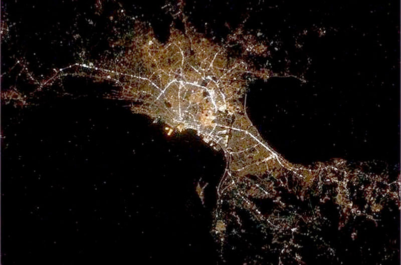
Manila Bay is on the left and Laguna de Bay is the dark area on the east. The arc of the semi-circle light is EDSA. The lights in the north is NLEX and in the south SLEX and other are the wider road networks of Rizal, Cavite, and Laguna provinces.
India vs. China. In the photo of the world depicting China and India (see April 14 column photos), both came out with the same light intensity in pictures. This demonstrates the danger of mixing composites of pictures into a larger map, using energy as indicator.
In the last 50 years, China’s economic growth has been more spectacular than India’s. Using the World Bank’s numbers, China’s GDP in 2018 per head was $9,580 and India’s $2,038 or 4.7 times bigger.
Technical differences such as distance in space of the camera in relation to each country, time-lapse-of-exposure or cloud cover and other factors, accounted for the relative brightness of India’s lights at night.
There is something interesting and positively true, however. The spread and relative sameness of lighting of India across its territories means that regional economic development in India is less unequal than China’s.
For archives of previous Crossroads essays, go to: https://www.philstar.com/authors/1336383/gerardo-p-sicat. Visit this site for more information, feedback and commentary: http://econ.upd.edu.ph/gpsicat/


- Latest
- Trending