Landslides, floods likely in the south: ‘Vinta’ nears
When a Signal No. 1 is raised, winds of 30-60 kilometers per hour with intermittent rains can be expected within at least 36 hours. Miriam Descada
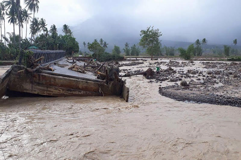
CEBU, Philippines — Residents in flood- and landslide-prone areas in Cebu are advised to take due precaution as approaching tropical storm Vinta is expected to dump rains over central and southern parts of the province today.
In particular, towns and cities in the south can expect heavy rains that may trigger floods and landslides as Vinta may be closest to Cebu – about 100 kilometers away – if it passes through Iligan City this afternoon, according to Alfredo Quiblat Jr., officer-in-charge of the Philippine Atmospheric, Geophysical and Astronomical Services Administration-Cebu.
“Residents, especially from southern and central Cebu, should prepare for heavy rain. It may be scattered or widespread,” Quiblat told The FREEMAN by phone last night.
As of yesterday morning, Tropical Cyclone Warning Signal No. 1 was hoisted over southern Cebu (covering Talisay City to Santander town), as well as other areas in the Visayas and Mindanao.
When a Signal No. 1 is raised, winds of 30-60 kilometers per hour with intermittent rains can be expected within at least 36 hours. In this case, plants and different crops might be uprooted and suffer significant damages and houses made of light materials may be partially unroofed.
As this report was written yesterday evening, Vinta had not yet reached landmass. In the 5 p.m. bulletin of PAGASA, Vinta was spotted 200 kilometers east of Surigao del Sur, where it is expected to make its first landfall.
Quiblat said Vinta has maintained its direction moving westward and is predicted to cross areas in Mindanao. With this observation, there is lesser chance that Vinta would change direction to west-northwest and make a landfall in southern Cebu.
Quiblat said there is also a slim chance that Vinta will further intensify and reach third category or “severe tropical storm.” In fact, it may weaken due to land interaction.
He said Vinta may even downgrade to first category “tropical depression” or maintain its strength as tropical storm (second category).
On alert
Dennis Atto, training officer at the Office of Civil Defense-7, urged the public not to take any chances even though the storm won’t affect Central Visayas directly.
“Whether mokusog or hinay ang Typhoon Vinta, dili ta pwede kompiyansa kay humok na kaayo atong yuta tungod sa Urduja. Nag-issue na ta og red alert status sa mga local government offices para ma-inform nila ang mga tawo,” said Atto in a telephone interview.
PAGASA raised a TCWS No. 2 in the following provinces: Surigao del Norte, Siargao Islands, Surigao del Sur, Agusan del Norte, Agusan del Sur, and Northern Davao Oriental.
Other places under TCWS No. 1 are Southern Leyte, southern portion of Leyte, Siquijor, Bohol, Dinagat Island, Camiguin, Misamis Oriental, Misamis Occidental, Bukidnon, Lanao del Norte, Lanao del Sur, North Cotabato, Maguindanao, Rest of Davao Oriental, Northern Davao del Sur, Compostela Valley, Davao del Norte, and Zamboanga del Sur.
The Philippine Coast Guard already cancelled sea trips from Cebu to these areas, leaving hundreds of passengers heading to their respective homes for the Christmas break stranded.
The Land Transportation Franchising and Regulatory Board-7 also suspended bus trips bound for Dumaguete City in Negros Oriental.
Yesterday, goods and equipment of the provincial and local government units in southern Cebu were already prepositioned as Vinta is expected to affect the south.
The Provincial Disaster Risk Reduction and Management Office said it is keeping tabs with the latest weather bulletin from PAGASA and is ensuring that the same is cascaded down to the LGUs.
Katherine dela Calzada of PDRRMO said each town or city in Cebu already has data on which places are most susceptible to disasters like landslides, floods, and storm surges. She called on local officials to disseminate information down to the barangay and even purok level to help attain zero casualty.
Dela Calzada also said the LGUs can request to borrow satellite phones from PDRRMO if communication bogs down, especially in barangays which won’t have cellular signal.
Most LGUs, though, have addressed the communication problem by purchasing two-way radios which work within the scope of the municipality, she said.
In Boljoon town, which is still under a state of calamity following a spate of landslides last October, officials have not yet recommended forced evacuation, according to DRRM officer Eutemio Ternate.
The town’s disaster council continues to monitor the situation on the ground, though.
Boljoon’s Barangay Upper Becerril and Lower Becerril are known to be prone to landslides and flooding.
In Talisay City, Mayor Eduardo Gullas alerted yesterday the City Disaster Risk Reduction Management Office (CDRRMO) to coordinate within the 22 barangays in preparation for Vinta.
CDRRMO head Alvin Santillana said that although they are celebrating Christmas party today, the disaster office is still on high alert for possible incidents.
Six backhoes and 11 dump trucks are on standby in the mountainous areas of Barangay Manipis. Operators are also ready to rescue possible victims of landslides.
Santillana reminded residents near Mananga River to be vigilant and evacuate immediately when water level rises.
Vinta is the 22nd tropical cyclone to develop and enter Philippine Area of Responsibility. Based on PAGASA’s 1948-2010 data, an average of 20 tropical cyclones enter PAR every year but only 10 cross or affect the country. — with Lorraine Mitzi A. Ambrad, Iris Mariani B. Algabre and USC Intern Edsel Torregosa (FREEMAN)


- Latest