Commentary: Reclamation-related floods and increasingly inequitable development
Coastal lands are environmental setting for aqua- and agriculture especially in islands. These are natural water filters and these mitigate the immediate and disastrous impact of high tides and tidal waves that lead massive flooding.
Coastal lands provide equitable and accessible housing and employment opportunities for people, and habitat for many different plants and animals. And, these are also the best carbon storages to lessen the severe impact of atmospheric pollution on public health and well-being. Their importance should never be underestimated.
Sadly, that is the case for Manila Bay, and at least 18 million people inhabiting the coastal lowlands of Bataan, Pampanga, Bulacan, Metro Manila, and Cavite.
Inequitable profit-centered development in the form of different types of reclamation along Manila Bay’s shores have poorly conserved its environment.
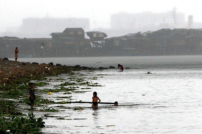
SPECIAL REPORT: Fed by the waters
Alarming evidence from development impact assessments and archaeological research on Manila Bay coastal heritage sites illustrated how, in at least the last 200 years, reclaimed lands from the dump and fill of mined soils or dredged sediments on coastal and nearshore areas worsened flooding in adjacent communities.
The largest coastal areas of Manila Bay are the Central Luzon and Greater Manila lowlands comprised of large rivers pouring into the bay.
Human settlements existed in these lowlands from at least the last thousand years. The earliest history of reclaimed lands, however, is the ‘tambak’ or fishponds dating back to at least about 400 years.
Unknown to many, Intramuros in Manila is the largest reclamation project during the Spanish period.
More recent reclamation includes portions of Ermita and Malate, including all of Roxas Boulevard developed during the American period; the Cultural Center of the Philippines complex and North and South harbor complexes built during the Marcos era; and the Mall of Asia/Newport City development and Cavitex Interchange established in the recent and arguably ‘profit-driven, corporation-controlled’ period of Philippine history.
Archaeological excavations in Lubao, Pampanga document landscape changes in the last 2,000 years, primarily from mangroves to agricultural lands. Land-use conversion, however was seen only in the last hundred years where rice fields were transformed to fishponds.
SPECIAL REPORT: Home is where the coast is
Local interviews documented a shift in land-use and natural resource control from the familial and community-centred to the profit-driven and export-oriented industry within the same period.
In the last few decades, census on local economy in the Central Luzon coastal lowlands showed a sharp shift from agriculture food production to trade and commerce.
Reclamation of mangrove forests turned to fishponds, artificial ports and harbors, and upscale private commercial-residential complexes consistently coincided with the worst flooding.
Geologists demonstrated how continuous ground water extraction following reclamations contributed to flooding in the last few decades. Climate change -related global warming led to sea-level rise that made the situation even worse.
Evidence from inequitable development-driven reclamation projects in Manila are stark and convincing.
Archaeological excavations documented at least a meter of land-fill used during the American development of Ermita and Malate. From mangroves and aquaculturally viable mudflats, these coastal lands turned into urban and gentrified residential areas spanning at least a kilometer from the Central Bank along Roxas Boulevard to St Scholastica’s College area on Leon Guinto Street.
Subsequent reclamation development exponentially increased flood levels as archaeologically documented in several excavations in Santa Ana, Manila. The worst floods were documented in the period coinciding with the last three government administrations, including the current one.
Environmental scientists and activists have repeatedly warned against the negative impacts of reclamation.
They predicted potential disasters from naturally occurring environmental phenomena like earthquakes, tsunamis and typhoons on reclaimed lands and structures.
History and archaeology clearly demonstrate that we need not wait for the future to test their predictions. We need only to look at the past to see the disaster we are already in.
Vito Hernandez is an International Postgraduate Research Fellow at Flinders University, South Australia, and Research Affiliate at the Biogeography, Environment, Evolution and Climate Laboratory of the University of the Philippines-Diliman. Email: [email protected]


- Latest